Share icon
Published
The Advanced Rapid Imaging and Analysis (ARIA) team at NASA's Jet Propulsion Laboratory and California Institute of Technology created this Damage Proxy Map (DPM) depicting areas that are likely damaged as a result of the November 26, 2019 earthquakes in
The Advanced Rapid Imaging and Analysis (ARIA) team at NASA's Jet Propulsion Laboratory and California Institute of Technology created this Damage Proxy Map (DPM) depicting areas that are likely damaged as a result of the November 26, 2019 earthquakes in Albania. The map was derived from synthetic aperture radar (SAR) images from the Copernicus Sentinel-1 satellites, operated by the European Space Agency (ESA). The images were taken before (November 14, 2019 and November 20, 2019) and after (November 26, 2019) the sequence of earthquakes. Credit: Contains modified Copernicus Sentinel data, processed by ESA. Analyzed by the NASA-JPL/Caltech ARIA team. This task was carried out at JPL funded by NASA.

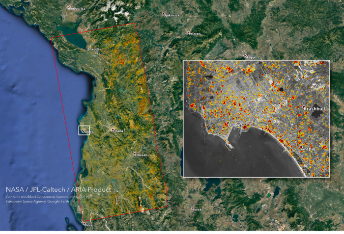
During a recent U.S. State Department “Observations and Communications Roundtable” meeting, NASA Disasters Program personnel briefed a delegation of several Italian disaster preparedness and response agencies on the work in which the program is engaged. One of the Italian delegation subsequently reached out to Disasters with a specific request for information on damage to structures in the epicentral region of an Albanian earthquake which occurred on Tuesday, November 26th, 2019. Disaster-affiliated researchers from the Advanced Rapid Images and Analysis (ARIA) team at NASA’s Jet Propulsion Laboratory were able to provide a damage proxy map that was then released to Italian officials. 

“This represents a good example of quick Disasters response to an urgent inquiry. The request was rapidly communicated to the relevant NASA team, and products were delivered within two days,” said NASA Disasters Postdoctoral Fellow Robert Emberson. “We could not ask for more.”

Related Impact

Story
News