Meet the SERVIR Scientists Improving Land Management Through Satellite Imagery
More than 100 countries at the UN Climate Change Conference this past year made the bold commitment to halt and reverse deforestation by 2030. But how is it possible to track the amount of forest cover lost or gained? And what kinds of metrics can drive decisions like where and how much land to set aside for agriculture or wildlife conservation?
Innovations in land cover and land use change (LCLUC) mapping are some of NASA’s most vital contributions to Earth science and sustainability. Since the launch of the first Landsat satellite in 1972, millions of images have been captured over the Earth’s surface. Over the past fifty years, these images have formed a record of the diverse ecosystems and landscape uses on our planet over time–enabling scientists, governments, and other stakeholders to map LCLUC changes on a scale never before possible.
SERVIR, a joint partnership of NASA and USAID, helps countries in Asia, Africa, and the Americas expand their capacity to use NASA Earth observations for sustainable land management. The SERVIR Applied Sciences Team (AST) is a group of Earth science experts selected by the NASA Applied Sciences Program to coordinate with co-investigators at SERVIR regional hubs, helping ensure that NASA science and technology is accessible and useful to users. Seven members of this team are currently working to help communities around the world not just engage in LCLUC mapping, but to access the resources needed to sustainably manage and protect the land we all live on.
Stephanie Spera
PROJECT: Quantifying the Effects of Forest Cover Changes on Provisioning and Regulating Ecosystem Services in the Southwestern Amazon
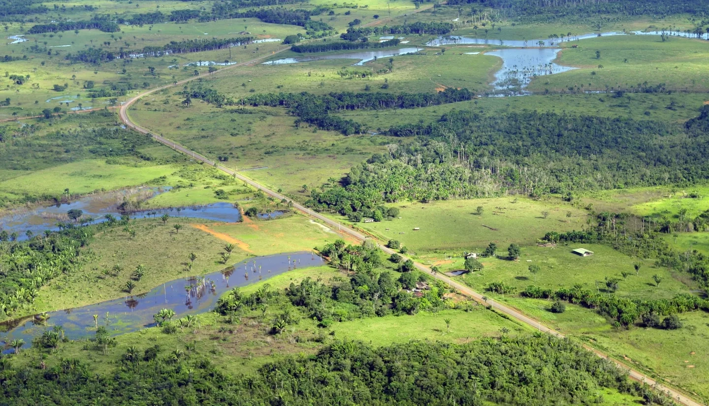
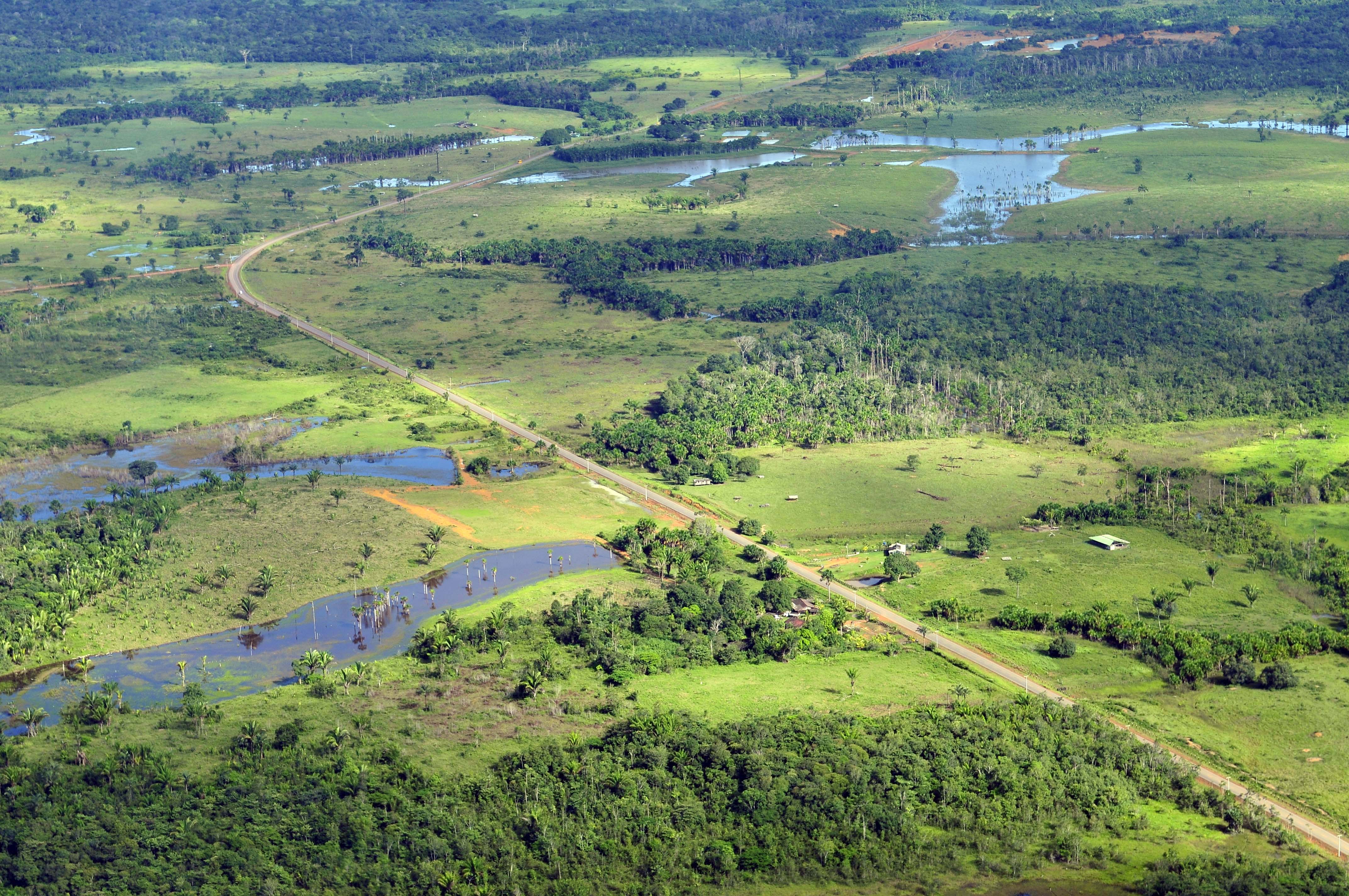
The call to save the rainforest and preserve one of the most critical ecosystems on our planet is a compelling one–so much so that multiple SERVIR projects are dedicated to this cause. Communities across South America depend on the Amazon rainforest for food and clean water, while the rest of the world benefits from the trees that act as the ‘lungs of the Earth’ in regulating our climate. However, determining how deforestation and forest degradation from logging, fires, and habitat fragmentation change ecosystem services (such as providing clean air and water) is a complex process.
Dr. Stephanie Spera, an assistant professor of geography at the University of Richmond, works with SERVIR-Amazonia and local indigenous organizations to better understand how current rates of deforestation in the Peruvian and Brazilian Amazon will impact the entire region. Losing forest in one area can cause regional-scale changes, impacting temperatures, rainfall, air quality, and even the water table.
If the full and far-reaching effects of deforestation are better understood, it can be easier for local governments to make land management decisions balancing economic and agricultural interests with conservation and emission reductions.
“Our work is both motivated by and grounded in collaboration with our local partners,” Spera said. She and co-investigator David Salisbury note the borderlands in their study area contain some of the last large swaths of intact forest in Amazon, but face pressure due to economic development needs. As mining, agriculture, and road-building activities increase, indigenous communities have reported less predictable precipitation and streamflow, drier soils, warmer air temperatures, and a less humid forest. “Our goal is to provide stakeholders across the Ucayali and Acre communities, [and] particularly our indigenous partners, with knowledge and tools to empower them, to inform decision making, and improve their resiliency,” Spera said.
Naiara Pinto
PROJECT: Unlocking the power of active remote sensing for ecosystem services modeling in the Amazon’s forest-agriculture interface
Rainforests like the Amazon can present numerous obstacles for scientists using satellite imagery to make LCLUC maps. Wetter climates obscure the landscape with dense clouds for much of the year, meaning clear images from optical sensors are often few and far between.
Similarly, rainforests are often cleared to make way for plantation crops like palm oil and cacao–plants whose canopies can be very difficult to distinguish from the undisturbed forests around them. Problems like these can be addressed with “active sensor” technologies, like synthetic aperture radar (SAR)-equipped satellites, with radar-based sensors that are unaffected by clouds, or LiDAR, which uses airborne lasers to capture incredibly precise measurements. However, many communities lack the software or training to use these technologies.
Dr. Naiara Pinto, a radar scientist based at NASA’s Jet Propulsion Laboratory, is on a mission to make active sensor technology more accessible to communities across the Amazon. Through SERVIR, Pinto is collaborating with groups like the Peruvian Cacao Alliance to collect data on agroforestry and plantation crops in the region. By capturing measurements of areas like cacao farms, SERVIR-Amazonia and partners can design geospatial services calibrated to address the unique challenges in rainforest research. The project is also training local personnel to work with SAR and LiDAR and incorporate these technologies more widely into their own job functions.
Douglas Morton
PROJECT: Forecasting seasonal to sub-seasonal fire and agricultural risk from drought in Amazonia
As more and more of the Amazon is deforested for expansion of cropland and pasture, the combination of forest loss and climate change pushes the system closer to a potential “tipping point:” a scenario where hotter temperatures and less rainfall could trigger a dieback of the rainforest. Fires further increase this risk of dieback. Drought conditions allow even planned fires to spread beyond their intended boundaries for land clearing or management. Fire is a leading cause of forest degradation, contributing to large losses of carbon storage and biodiversity as the Amazon’s forests are not adapted well to fire. For effective Amazonian conservation, local authorities need reliable LCLUC services to forecast the areas at higher risk of fire activity, and quickly respond to fires most likely to have the heaviest impacts on communities and sensitive ecosystems.
Among those supporting this effort is Dr. Douglas Morton, Chief of the Biospheric Sciences Laboratory at NASA’s Goddard Space Flight Center. Morton and his team have developed a seasonal fire forecast that aims to provide insights about climate-driven fire risk three to six months before the peak of each fire season. The link between drought and fire provides an early warning system that can help bring attention to the regions at greatest risk. Morton’s team also developed another service to identify and track individual fire events. The Amazon Dashboard (part of the Global Fire Emissions Database funded by NASA, The Gordon and Betty Moore Foundation, and the Netherlands Organization for Scientific Research) distinguishes between deforestation fires, forest fires, savanna burning, and small agricultural fires in near-real time. With thousands of fires burning on any given day in the Amazon, the Dashboard supports regional fire managers tasked with controlling specific fire types–whether from illegal deforestation or other fires burning into protected areas.
“Satellites are often the first to detect fires burning in remote regions of the Amazon. Using the latest generation of active fire data, we can now detect fires burning under the forest canopy and relay this information to regional and national entities tasked with fire management,” Morton said. “Early detection of forest fires is a major new advance in the effort to limit forest degradation in the Amazon–safeguarding forest carbon and biodiversity.”
Peter Potapov
PROJECT: Supporting operational regional land cover monitoring at high spatial and temporal resolution for the Hindu-Kush-Himalayan region
In the mountain ranges across the Hindu Kush Himalaya, local governments face unique challenges when making decisions about how to manage natural resources sustainably. The effects of climate change are putting a strain on these rare, vulnerable ecosystems endemic to the mountains. From hotter temperatures and melting snowpack to increasingly variable precipitation extremes, these changes increase the risks of disasters such as wildfires, floods, and landslides. The rapid urbanization of the region creates other pressures, as more land and natural resources are necessary to accommodate the growth of cities. To communities in the region, LCLUC mapping is vital to mitigating the risk of these environmental hazards, as well as sustainably managing forests and agricultural land to meet the needs of a growing population.
Dr. Peter Potapov is a professor of geography at the University of Maryland and the co-director of the Global Land Analysis & Discovery group (GLAD). Together with the SERVIR-Hindu Kush Himalaya hub and the International Centre for Integrated Mountain Development (ICIMOD), Potapov’s work has helped create land cover monitoring services tailor-made to the unique demands of these mountain landscapes. From this effort, the Regional Land Cover Monitoring System (RLCMS) launched in September now gives communities in the region access to almost 20 years worth of high-resolution annual LCLUC maps adjusted for the specific needs of local decision-makers. Potapov also works across Nepal, Bangladesh, and Pakistan, hosting events for local decision-makers interested in improving their land cover modelling skills.
“The RLCMS system supports national progress towards sustainable land management and provides important data to estimate greenhouse gas emissions to fulfill the national requirement to the Paris Agreement within the United Nations Framework Convention on Climate Change (UNFCCC),” Potapov said. The project supports ongoing REDD+ project activities, and forest monitoring components of RLCMS have already been adapted by several national agencies, such as the Bangladesh Forest Department. The data and tools provided by Potapov’s team help countries more efficiently perform land cover monitoring, forest change assessment, and GHG reporting, freeing up scarce resources for additional data collection and analysis.
Robert Kennedy
PROJECT: Leveraging cloud-computing and an integrated disturbance and vegetation mapping framework for protected areas monitoring in the Lower Mekong
A hemisphere away, critical ecosystems in southeast Asia’s Lower Mekong River Basin rely on protected conservation areas often threatened by climate change, rapid urbanization, and large-scale agroforestry. These areas are incredibly valuable to communities in the region, bolstering local tourism, harboring endemic biodiversity, and playing a central role in helping countries meet emissions reduction goals. To manage these areas sustainably, local authorities need a way to not only measure land cover change over time, but also understand and communicate the impacts of those changes.
Safeguarding basin ecosystems for future generations requires bringing in the latest technology in LCLUC mapping–the core of Dr. Robert Kennedy’s project. Kennedy, a professor of geography at Oregon State University, collaborates with scientists at the Asian Disaster Preparedness Center (ADPC) and the U.S. Forest Service to help countries like Cambodia make use of advances in cloud computing and land cover modeling algorithms.
“Cambodia’s forests have the capacity to fulfill human needs and the needs of the critters and natural processes that depend on them, but these forests have been under intense pressure in recent decades. Better management of the forests can only occur when folks on the ground know what is happening and where, and that’s what our project focuses on,” Kennedy notes. “It’s been gratifying to work through SERVIR with conservation partners like the Wildlife Conservation Society to bring our fancy algorithms into the hands of people who can use them in the real world. Not only does it help conserve the forest in the short term, it empowers those who live in and around it to make better long-term decisions.”
Pontus Olofsson
PROJECT: Supporting continuous monitoring and sample-based estimation of land change and forest degradation in West Africa

As is the case in Amazonia and the Lower Mekong, urbanization and large-scale agroforestry are also threats faced by West Africa’s forests. Without consistent maps and estimates of land cover and land cover change across the region, local governments can have a difficult time taking precautions to protect key habitats. Deforestation and the more subtle, hard-to-track degradation of forests can jeopardize key ecosystem services, international emissions commitments, and food security in these countries.
The use of Earth observations in West Africa has been hampered by a remarkable lack of satellite data. In fact, West Africa exhibits some of the lowest densities of satellite data in the world. This issue is partially related to cloud cover, but more critically due to receiving stations’ global acquisitions plans and activities. However, the end result is that remote sensing applications and workflows common in other parts of the tropics are much harder to apply to West Africa.
Dr. Pontus Olofsson, a professor at Boston University’s Department of Earth and Environment, is supporting SERVIR researchers and decision-makers across West Africa in accessing the tools and skills for regionally-specific LCLUC projects. This includes working with local partners to develop tools in Google Earth Engine to make it easier for local communities to generate reliable maps and area estimates of relevant land categories and processes. Collaborating with these communities to get sample data on the ground, Olofsson and his co-investigators prioritize creating tools and workshops attuned to the local landscapes, and simplifying time-series visualizations, ensuring services aren’t just easy to use, but carefully tailored to be useful to real communities.
Jasmeet Judge
PROJECT: Linking deforestation, urbanization, and agricultural expansion for land-use decisions in Ghana - The Ghana Land Use Project (GALUP)
Climate action and sustainable land management often involves carefully balancing the interests of many stakeholders. In countries like Ghana, LCLUC scientists have an important role to play in informing negotiations between competing needs such as urban expansion and increased cropland conversion to accommodate population growth, and environmental conservation for clean air and biodiversity. To address the needs of these many stakeholders, it helps if communities have clear information about not only existing land cover, but also what changes can be expected from different land management decisions.
Dr. Jasmeet Judge, a professor in agricultural and biological engineering at the University of Florida, is partnering with Ghanaian organizations such as the Land Use and Spatial Planning Authority (LUSPA) to develop a planning framework for land management decisions. Until recently, land use planning in Ghana was mostly paper-based, lacking technology and data inputs to make more effective decisions. Data from satellites offer unprecedented opportunities to impact land management in the region. GALUP’s open-source planning framework combines satellite remote sensing, ground-based land data, and socioeconomic information to provide a holistic understanding of how decisions might impact the landscape. The effort also includes building technical capacity in land use modeling and remote sensing to personnel at LUSPA and various district governments for sustained use of the framework.
“The GALUP team is committed to making satellite data accessible and explainable for informed land-use planning decisions,” Judge said. “Our partners at LUSPA are mindful of the role information technology plays in spatial planning, and are actively engaged in workforce development to acquire GIS and remote sensing skills. It is rewarding to know that the premier decision-making organization in Ghana will be well-prepared to use the latest information for regulating the use of land efficiently and ethically, balancing the needs of local communities while safeguarding natural resources.”
As the global community works to address climate change, building strong relationships between LCLUC scientists and the public is vital to find land management solutions that work for both the environment and the community. SERVIR and the Applied Sciences Team, hand in hand with local collaborators and co-investigators are taking needed steps towards making these difficult decisions just a little easier.
This article is the second in a series highlighting members of the SERVIR Applied Sciences Team. For more information, read on about the AST members studying agriculture and food security, and stay tuned for future features on water and weather applications!

