The worst drought since the development of the U.S. Drought Monitor in 1999 covered three-quarters of the contiguous U.S. in 2012, slamming the Southeast with record dryness. By June, Alabama was suffering not only through a long-term drought, but northern parts of the state were also hit by a “flash drought.”
A flash drought is a sudden onset of high temperatures and decreased soil moisture, which can reach maximum intensity in a matter of a few weeks, as opposed to months or years. It can be just as bad as a long-term drought, except the damage sneaks up on farmers much more quickly.
“Agricultural stress occurs when crops do not have adequate soil water during their growth cycle,” explained Christopher Hain, an agricultural scientist at NASA Marshall Space Flight Center in Huntsville, Alabama. “Even if the stress doesn’t lead to failure of the crop, it can have significant impacts on end-of-season yield.”
When the flash drought struck, a NASA Earth Applied Sciences project addressing agricultural drought in the southeastern U.S. was already in place. The project team had recently used NASA’s Land Information System to aggregate environmental information like soil moisture and ground temperature to build a real-time crop model. The impact of solar radiation on agriculture was measured using satellite data and included in the model as well.
“In our work with [Dick McNider] we have become aware of the special agricultural drought impacts that can occur rapidly due to poor water holding capacities of soils… We believe the real-time crop modeling-based approach to capture agricultural drought may be applicable to other regions [as well].”
–Michael Hayes, National Drought Mitigation Center
Throughout the summer of 2012, Alabama’s state climatologist and the Alabama Office of Water Resources used the crop model in weekly drought status meetings, including teleconferences with the National Drought Mitigation Center (NDMC) at the University of Nebraska-Lincoln. The project team also delivered data products in real time to climatologists, water resources managers and the U.S. Department of Agriculture’s National Agricultural Statistics Service.
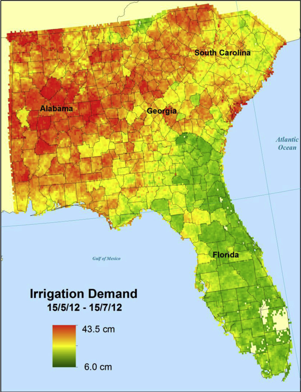
After the growing season, the team used the model to analyze the impact of the flash drought on corn yields. The data showed that in many areas of northern Alabama, yields were below 50 bushels per acre – less than half the state’s average. In computing weekly irrigation demand in the Southeast, the team’s analysis suggested that even modest irrigation would have increased yields to nearly 200 bushels per acre.
The benefits of the project actually preceded the support NDMC gave during the 2012 drought. Earlier in the year, then-Alabama Governor Robert Bentley signed an irrigation tax credit, which was based largely on data and analysis from the project.
The tax credit, up to $10,000 per year per farm, is an incentive for farmers to invest in irrigation systems. Policy makers and water resources experts predict that, in the coming years, expanded irrigation will increase revenue for farmers through higher crop yields, while reducing costs for poultry and livestock producers through cheaper feed grains. That’s a big boost for a state where agriculture contributes approximately $5 billion in cash receipts annually. In the face of drought, Alabama can turn to space-based Earth observations to help keep its agriculture growing.
This story is part of our Space for U.S. collection. To learn how NASA data are being used in your state, please visit nasa.gov/spaceforus.


