
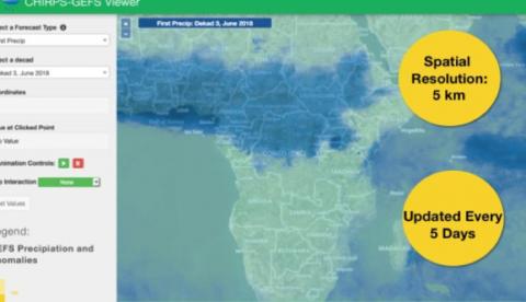
The timing and onset of rainfall is crucial for hundreds of thousands of farmers in the developing world when sowing, fertilizing and harvesting crops. Unpredictability in weather, and rainfall in particular, poses a serious challenge that results in missed opportunities for maximizing crop yields. SERVIR and the Climate Hazards Group (CHG) at University of California at Santa Barbara have developed an improved rainfall forecast dataset, CHIRPS-GEFS, which merges two highly recognized datasets: Climate Hazards Group InfraRed Precipitation with Station (CHIRPS) and the Global Ensemble Forecasting System (GEFS). The combined CHIRPS-GEFS dataset uses the higher spatial resolution of CHIRPS and the advanced forecasting ability of GEFS to provide up to a 16 day forecast updated every five days at a spatial resolution of 5 km across the globe. CHIRPS-GEFS is available for analysis and download through SERVIR's Product Catalog.
The University of Santa Barbara’s Climate Hazards Group (chg.ucsb.edu), the group that started generating the CHIRPS dataset with support from the US Geological Survey and USAID, is also producing the new CHIRPS-GEFS data. The CHIRPS-GEFS rainfall dataset is currently available with data beginning from 1985. National Centers for Environmental Prediction (NCEP) started the GEFS effort to address uncertainty in weather observations, which is used to initialize weather forecast models.
Although NCEP’s GEFS consists of 21 different simulations that each produce a 16 day forecast every six hours, the resolution may range from 25 to 100 kilometers, making it difficult to assess varying rainfall levels across different areas. Furthermore, each of the 21 simulations have their own biases, causing decision makers and farmers to be uncertain of the accuracy of each prediction. However, when GEFS data is merged with CHIRPS historical rainfall data, the combined dataset is able to account for these biases, which results in a more reliable prediction at a higher resolution of 5 kilometers.
“Most developing regions don’t have irrigation, so farmers need to know when rain is coming to plant seeds in advance,” says SERVIR Chief Scientist Ashutosh Limaye. “Because CHIRPS-GEFS improves the spatial resolution with an uncertainty estimation of a rainfall forecast in the next two weeks, the dataset can provide farmers with the confidence they need to plan accordingly.”
SERVIR connects space to village by helping developing countries use satellite data to address critical challenges in food security, water resources, weather and climate, land use, and natural disasters. A partnership of NASA, USAID, and leading technical organizations, SERVIR develops innovative solutions to improve livelihoods and foster self-reliance in Asia, Africa, and the Americas.