NASA Harvest researchers are featured in a series of short, relevant and educational agricultural videos developed by NASA eClips that integrate mathematics, science, data literacy and geography to connect people to real-world projects. NASA Harvest works with partners and stakeholders to collect and interpret Earth-observing satellite imagery, sharing satellite data with food producers and decision makers around the world to address global food production and food security.
In these videos, NASA Harvest's Dr. Inbal Becker-Reshef, Dr. Catherine Nakalembe, and Dr. Hannah Kerner describe how NASA uses satellites to monitor crop development and help decision makers improve food security. The videos focus on science and technology education for children in grades 3-5 and 6-8, and introduce the audience to topics in ecology and mathematics.
Real World: Food Security-Monitoring Crops from Space
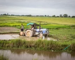
By measuring the impact of natural resources such as water, air, nutrients, sunlight and heat, on crop conditions, NASA Harvest can better inform decision-making and help ensure that enough food is produced to feed the world’s entire population. This video explains how NASA’s Earth-observing satellites gather data to monitor plant growth and crop yield, a measurement of how much food is produced in a given area, to predict food supply and food shortages worldwide in a way that can inform important local decision-making.
Our World: Where Do Crops Grow?
If you’ve ever wondered “Where does food come from?”, you’re not alone. The food you eat every day is grown in different agricultural regions around the world depending on various geographical features and environmental factors.
NASA Harvest helps food producers and agricultural analysts “see” with satellite data imaging that shows the health and location of crops globally. By mapping and monitoring farms on Earth, and partnering with farmers and the commercial sector to gather ground information, NASA Harvest can help communities strengthen food security, and connect concepts like pixels and spatial resolution to putting food on the table.
More about how Harvest helps deliver data to the local communities can be found on the NASA Harvest homepage.
NASA eClips is a NASA-supported project that brings together exciting video segments and resources with educational best practices to inspire and educate students to become 21st Century explorers.