Sections
On Thursday, March 19th, the National Oceanic and Atmospheric Administration (NOAA) issued its "Spring Outlook" for 2020 to inform the public what weather patterns they can expect for the upcoming season. This outlook will help emergency managers and community decision-makers along the nation’s major waterways prepare people and businesses for the threat of floods. According to the report, "NOAA forecasters predict widespread flooding this spring, but do not expect it to be as severe or prolonged overall as the historic floods in 2019. Major to moderate flooding is likely in 23 states from the Northern Plains south to the Gulf Coast, with the most significant flood potential in parts of North Dakota, South Dakota and Minnesota." Read the full press release here.
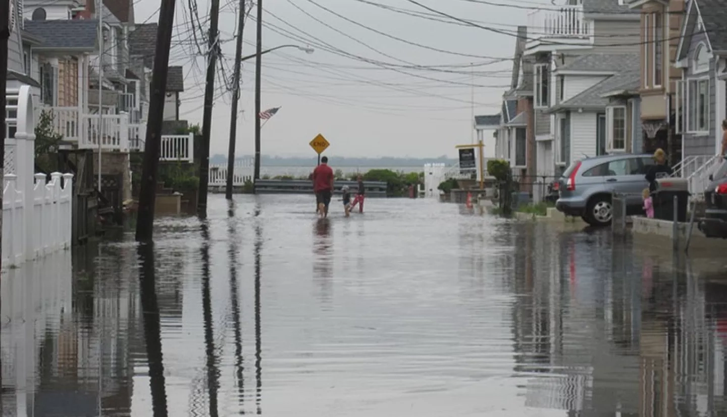
In the United States, floods account for more deaths than any other disaster; resulting in more loss of life and property than other types of hazards and severe weather events. This is due to the multifaceted nature of flood events. For instance, the US Eastern and Gulf coasts are particularly vulnerable to storm surges from hurricanes, while the Northeast and North Central U.S., and some areas of the Western U.S. are more susceptible to excessive rainfall, snow/ice melt, and dam failures. In Alaska the Upper Midwest and other areas, river ice jams can also cause severe flooding.
In its role to improve the prediction of, preparation for, response to, and recovery from disasters and natural hazards, the NASA Earth Applied Sciences Disasters program will be keeping a close watch on the flood conditions around the U.S. While NASA is not an operational response agency like NOAA, it does have specialized Earth-observing satellites, airborne assets and experts that can provide unique capabilities to assess flood impacts and inform actionable decisions through all phases of the emergency management cycle. The program stands ready to aid communities with NASA data and apply their emergency management expertise and cutting-edge research to tackle the challenges that floods bring.
This article will examine some of the unique tools and datasets that NASA provides to aid with flood response, and some of the ways NASA has helped tackle floods in the past.
NASA Disasters Mapping Portal - U.S. Floods Dashboard
View fullscreen on the NASA Disasters Mapping Portal
The NASA Disasters Mapping Portal is a web platform that provides access to near real-time and value added data products in geographic information system (GIS) format, through web applications, map layers, and API's. The Mapping Portal provides NASA data in a beneficial format for emergency managers and GIS specialists within local, state, federal and international disaster response agencies. The Flood Dashboard shown above brings together multiple soil moisture and flood products from NASA, the National Weather Service and USGS to give a more complete picture of potential flooding in the United States.
NASA Flood Data Products
GPM IMERG Rainfall Estimates
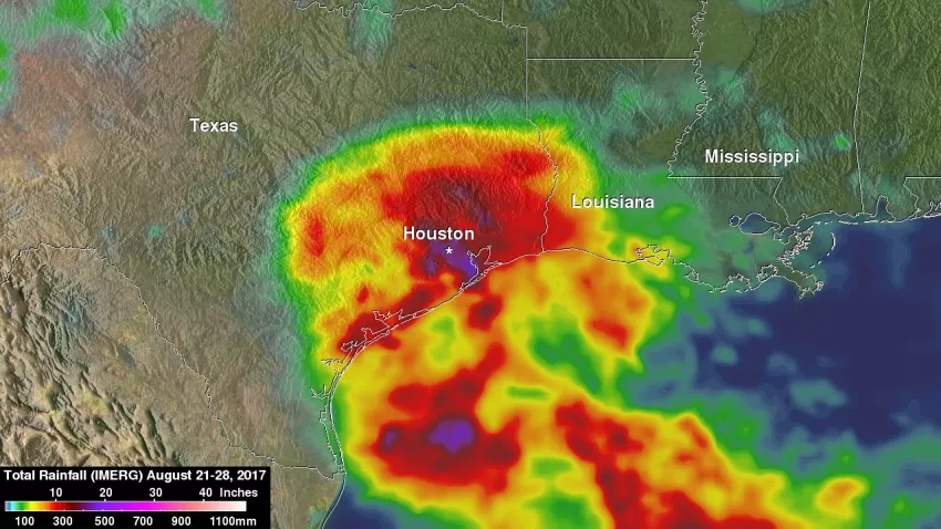
NASA's Integrated Multi-satellitE Retrievals for GPM (IMERG) uses satellites in the GPM Constellation and rain gauge networks to provide a global precipitation product updated every half hour. This dataset provides valuable information that can help determine the extent and impact of flooding rainfall. IMERG is used by the UMD Global Flood Monitoring System (GFMS) to detect potential flooding conditions and estimate intensity (http://flood.umd.edu/). IMERG data is also integrated into the Landslide Hazard Assessment for Situational Awareness (LHASA) model to create landslide "nowcasts" that warn of potential landslide conditions around the world and provide situational awareness of landslide hazards. (https://pmm.nasa.gov/articles/modeling-landslide-threats-near-realtime)
Learn more: https://pmm.nasa.gov/articles/two-decades-imerg-resources
MODIS Near Real-Time Global Flood Mapping
The Moderate Resolution Imaging Spectroradiometer (MODIS) instrument onboard NASA's Aqua and Terra saetllites is used to detect water extent in support of flood response and recovery. The MODIS Near Real-Time Global Flood Mapping Project produces global daily surface and flood water maps at approximately 250 m resolution, in 10x10 degree tiles.
Learn more: https://floodmap.modaps.eosdis.nasa.gov/
SMAP Soil Moisture
The NASA Soil Moisture Active Passive (SMAP) satellite is a remote sensing observatory that carries two instruments that can map soil moisture and determine the freeze or thaw state of the same area being mapped. Soil moisture is a key variable in water-related natural hazards including floods and landslides. High-resolution observations of soil moisture and landscape freeze/thaw status lead to improved flood forecasts, especially for intermediate to large watersheds where most flood damage occurs.
Learn more: https://smap.jpl.nasa.gov/science/applications/
View More NASA Flood Datasets and Resources at NASA Earth Data
A.37 ROSES Flood Research Projects
NASA Research Opportunities in Space and Earth Science (ROSES) proposal requests fund basic and applied research to support the work of NASA’s Science Mission Directorate (SMD). Below are described several current ROSES research projects with applications for flood monitoring and response.
Advancing Access to Global Flood Modeling and Alerting
Principal Investigator: Dr. Margaret T. Glasscoe
Obtaining highly reliable information about flooding events on a global scale currently requires the manual review and integration of multiple sources. There is a great variety of data, each part of which may or may not be relevant for a particular scenario, and each with different access mechanisms. Given that floods are both the most deadly and most costly natural hazards, this project will integrate flood inundation information from multiple sources into the DisasterAWARE (All-hazard Warnings, Analysis, and Risk Evaluation) platform, providing a single source of global information on floods that is supported by a common, normalized data model. End users will no longer be required to extract and merge data from multiple sources by hand as this will be done automatically by the middleware.
Development of Predictive Models to Improve Landslide Disaster Risk Reduction and Response
Principal Investigator: Dr. Dalia Bach Kirschbaum
Landslides globally cause loss of life and lasting damage to critical infrastructure. A major rainfall or earthquake can trigger tens of thousands of landslides, compounding losses from damage to transportation networks that inhibit disaster response, resulting in cascading effects such as flooding and debris hazards. Despite their ubiquitous nature in many natural disaster scenarios, there is little integration of pervasive landslide impacts throughout the complete landslide disaster life cycle, including preparation, recovery and mitigation. This proposal supports key decision-making and resilience-building capabilities related to landsliding for a wide range of stakeholder partners, as well as publicly served data and models that will be available through partner websites. The project will advance landslide forecasting using predictive models, satellite data and ground observation, including evaluation of landslide risk based on the hazard model outputs combined with exposure and vulnerability data. It will address the impact of widespread landsliding triggered by disaster events, including tropical cyclones and earthquakes, where landslides are a significant secondary hazard interrelated with the effects of strong ground shaking and flooding. Importantly, it seeks to cover a range of spatial and temporal scales that are relevant to our stakeholder decision making and response needs through an integrative approach of empirical and mechanical modeling.
Integrating Synthetic Aperture Radar Data for Improved Resilience and Response to Weather-Related Disasters
Principal Investigator: Dr. Franz Meyer
Weather-related hazards are ubiquitous in the United States, including: 1) hurricane storm surges impacting coastal areas, 2) rapid snow melt and heavy rainfall causing basin-scale flooding, 3) severe weather leading to flash floods and tornadoes, and 4) seasonal freeze and thaw of rivers that may lead to ice jams. Each of these hazards affects human settlements ranging from major cities to rural areas and has the potential to significantly impact agricultural productivity. In each setting, end-user partners engaged in disaster management need access to data-processing tools helpful in mapping past and current disasters to capture their impacts. Analysis of past events supports risk mitigation by understanding what has already occurred and how to alleviate those impacts in the future. This project will develop a cloud-based automatic data analysis toolbox for the processing of SAR data into value-added products that address the mapping of meteorological and hydrological disasters, such as heavy rainfall and flooding, as well as related cascading hazards, such as landslides and levee instability. The integration of these products into end-user decision-making workflows will improve capacity in the use of SAR in response situations.
See All Disasters Program A.37 ROSES Research Projects
Flood Research Community Partnerships
GEO GFRM
NASA Disasters Program Manager David Green and his team lead the Group on Earth Observations (GEO) Global Flood Risk Monitoring (GFRM) Community Activity. GEO GFRM develops, tests and applies methods to utilize satellite remote sensing and other Earth observations with models and maps to estimate location, intensity and duration of floods globally in real-time, and develop durable monitoring systems of flood risk with climate change. By utilizing observations of actual floods as well as increasingly accurate satellite data-driven global hydrological models to accommodate floods in their changing climate and changing environment context, they aim to address flood hazard and exceedance risk probabilities directly.
Learn more: https://www.earthobservations.org/activity.php?id=94
Access GEO GFRM data: https://geo-floodrisk-nasa.opendata.arcgis.com/
CEOS Disasters Working Group
David Green also chairs the Committee on Earth Observation Satellites (CEOS) Disasters Working Group (WGDisasters). The CEOS WGDisasters ensures the sustained coordination of disaster-related activities undertaken by the CEOS Agencies and acts as an interface between CEOS and the community of stakeholders and users involved in risk management and disaster reduction. The goal of the working group is to support the efforts of Disaster Risk Management authorities in protecting lives and safeguarding property by means of satellite-based Earth-observations (EO) and science-based analyses, foster increased use of EO in support of Disaster Risk Management, support the implementation of the UNDRR Sendai Framework for Disaster Risk Reduction, and Raise the awareness of politicians, decision-makers, and major stakeholders of the benefits of using satellite EO in all phases of Disaster Risk Management.
Learn more: http://ceos.org/ourwork/workinggroups/disasters/
Flood Articles
Helping Communities Stay Above Water in Floods
Arkansas lives up to its nickname of The Natural State, with three national forests covering 2.9 million acres, seven national parks, scenic mountains and plains, and dozens of rivers bordering and crossing the state, including the mighty Mississippi. But with all those rivers, flooding is a recurring natural hazard. For those providing relief and other emergency services to flooded areas, timely NASA Earth observations help determine the scope of the disaster.
When the Ohio River Floods
A defining characteristic of Kentucky is the Ohio River, which comprises more than 500 miles (800 kilometers) of the state's northern border. The river is an invaluable resource for Kentucky’s economy, ecology and recreation. But the Ohio River and its tributaries also make Kentucky prone to frequent flooding – especially in the winter and early spring when heavy rainfall and snowmelt can overwhelm the Ohio Valley. That was the case in February 2018, when the worst flooding in more than two decades swamped several states along the Ohio River.
Easing Hurricane Matthew's Misery
Stretching from the Appalachians to the Outer Banks, the Tar Heel State can boast a lot of superlatives. It was the “first in flight,” it’s home to the highest mountain east of the Mississippi River and it has the tallest brick lighthouse in the United States. It’s also one of the most susceptible states to tropical storms and hurricanes in the United States. A tropical cyclone lashes the Atlantic coast of North Carolina about once every four years. In 2016, however, North Carolina was hit by several tropical systems. The most devastating by far was Hurricane Matthew, which left historic flooding and widespread destruction in its wake.
Helping Cities Stay Dry When Sea Levels Rise
Beaches and parks along that shoreline remain a staple of Virginia’s tourism business – 19 million people visited Virginia Beach alone in 2017. But the Tidewater region is seeing an influx not of tourists, but of coastal flooding from rising seas. The Hampton Roads area – which includes Virginia Beach, Norfolk, Newport News, and other municipalities in southeastern Virginia and northeastern North Carolina – has been exceptionally vulnerable. NASA used a satellite reanalysis of Hurricane Irene to better understand current and future flood threats, so city planners and emergency managers can map out various flood scenarios and make infrastructure plans accordingly.


