Displaying 11 - 12 of 12
![NDVI-processed image from Landsat 8 OLI June 2022 data. Black and magenta indicates Portland's built landscape, with the bright magenta depicting the highest concentrations of impervious surfaces. In light pink, the Willamette River dissects the city with surrounding green vegetation. The NDVI conveys areas with high urban build-up with a lack of access to greenspace, illustrating lived experiences of urban heat and contributing to Depave's knowledge of areas that are in most need of depaving.](/sites/default/files/styles/lis/public/2024-01/2023Sum_VEJ_PortlandUrban_WebsiteImage.png.webp?itok=hUDAucTE)
Topic
Portland Urban Development (Summer 2023) Team: Keegan Kessler (Project Lead), Hadwynne Gross, Jordan Larson, Adam Nayak Summary: Urban heat is a pressing concern in Portland...
![Land surface temperatures for study area (Cuyahoga County, Ohio), as derived from Landsat. Black lines show boundaries of census blocks. Blue dots show the greenspaces and census blocks where the on the ground tree surveys have been conducted, with one census block highlighted as an inset. Image Credit: Rob Moore (Cleveland State).](/sites/default/files/styles/lis/public/2024-05/Mueller%20Project%20Page%20Image_0.png.webp?itok=nYl76fWk)
Topic
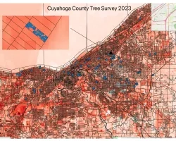
Team: Kevin Mueller (Cleveland State University), Brice Grunert (Cleveland State University), Thomas Hilde (Cleveland State University), Kaiguang Zhao (Ohio State University), Daniel Meaney (Cuyahoga County...