Displaying 1 - 4 of 4
![Satellite image of smoke from wildfires.](/sites/default/files/styles/lis/public/2021-03/Wildfires_Header.png.webp?itok=eTz5Y-T-)
Training Type
Level
Intermediate
Date
May 11, 2021 - May 27, 2021
![Satellite image of smoke from wildfires.](/sites/default/files/styles/lis/public/2021-03/Wildfires_Header.png.webp?itok=eTz5Y-T-)
Training Type
Level
Intermediate
Date
May 11, 2021 - May 27, 2021
DEVELOP
Wildland Fires
Climate
Capacity Building
Ecological Conservation
Health & Air Quality
Water Resources
![Land surface temperatures for study area (Cuyahoga County, Ohio), as derived from Landsat. Black lines show boundaries of census blocks. Blue dots show the greenspaces and census blocks where the on the ground tree surveys have been conducted, with one census block highlighted as an inset. Image Credit: Rob Moore (Cleveland State).](/sites/default/files/styles/lis/public/2024-05/Mueller%20Project%20Page%20Image_0.png.webp?itok=nYl76fWk)
Topic
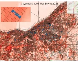
Team: Kevin Mueller (Cleveland State University), Brice Grunert (Cleveland State University), Thomas Hilde (Cleveland State University), Kaiguang Zhao (Ohio State University), Daniel Meaney (Cuyahoga County...