On March 25, 2021, leaks were discovered in the containment wall of a 77-acre pond holding approximately 460 million gallons of wastewater at a former phosphate plant at Piney Point, Florida, about 20 miles south of Tampa. To prevent a collapse of the stack containment walls holding back wastewater, the Florida Department of Environmental Protection (FDEP) approved a controlled discharge from the site into Port Manatee.
On April 3, officials were notified that a potential breach of the south reservoir at the facility could flood roads and homes and wash into Tampa Bay. In response, Florida Gov. Ron DeSantis issued a State of Emergency to ensure resources were allocated for necessary response and recovery. Officials ordered the evacuation of more than 300 homes and closed off U.S. Highway 41 near the reservoir that same day. After data from the U.S. Army Corps of Engineers showed a diminished risk for an uncontrolled breach of water from the stacks, state officials lifted the evacuation order and re-opened the highway on April 6.
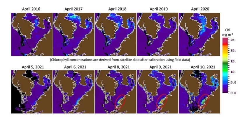
Wastewater leakage events such as this may have implications for water quality, ocean biology, health and ecosystem disaster risk. Because of this, NASA’s Earth Science Applied Sciences Disasters program area activated on April 8. NASA Disasters Program coordinators across the U.S. immediately mobilized to explore, assess and identify Earth-observation assets and data – including satellites, airborne, models, experts and partnerships – that might provide the most benefit. The program has engaged with relevant researchers, contacts, and global and local stakeholders seeking innovative solutions, whether those solutions are available from NASA or via the agency’s extensive and worldwide research community.
Satellites are critical tools for early detection and tracking potential environmental issues such as harmful algal blooms (HABs). Researchers can use several Earth-observing satellites, such as NASA’s Terra and Aqua satellites, the joint NASA/USGS Landsat satellites, and the European Space Agency’s Copernicus Sentinel-2 and Sentinel-3 satellites to monitor algal blooms from space. Factors such as the timing needed to capture a cloud-free image when a satellite passes over the algal bloom and resolution of the satellite instrument influence which satellites may deliver the most valuable results. Images such as the ones below can serve as a tracer of wastewater discharge. By combining the observations of red, green, and blue light reflected by the Earth at each 10 meter pixel, it is possible to visualize where the water is more blue (deep and clear water), green (somewhat more turbid water with some suspended particles such as phytoplankton), or yellow to brown (shallow vegetation or very turbid water with high concentrations of phytoplankton and colored dissolved organic matter).
On April 9, the damage to the containment walls appeared to be localized, and steps were taken to contain the potential for further containment failure. Additionally, the FDEP reported approximately 215 million gallons of wastewater had been discharged to the port; however, all controlled discharges of untreated water to Port Manatee and Piney Point Creek have been ceased since that day. Beginning April 16, FDEP noted bloom conditions in the localized area of previous discharges, but with test results measuring cyanotoxins in the water ranging from non-detection to trace levels. As of April 21, FDEP also reported no fish kills in the area.
NASA’s Disasters program area continues to coordinate with representatives from NOAA, the USF Institute for Marine Remote Sensing, the Florida Institute of Oceanography, and other programs from within NASA’s Earth Science Division.
Click here for the latest updates on the Piney Point Wastewater Leak from the FDEP.


