For the past two decades, the primary source of global fire observations has been NASA’s Terra and Aqua polar-orbiting satellites, which carry the Moderate Resolution Imaging Spectroradiometer (MODIS), followed by the NASA-NOAA Suomi-National Polar-orbiting Partnership (S-NPP) Visible Infrared Imaging Radiometer Suite (VIIRS), but these systems are limited to 2-8 observations per day, with acquisition times that often do not coincide with the most intense period of fire, or which are more susceptible to cloud obscuration, resulting in limited mapping of fire occurrence. The next generation of geostationary weather satellites, which include the NOAA Geostationary Operational Environmental Satellite (GOES), EUMETSAT Meteosat Second Generation (MSG), and Japan Meteorological Agency Himawari platforms, now include a fire monitoring capability and incorporate refinements in spatial and temporal resolution as well as radiometric performance. These platforms provide unrivalled temporal sampling of fire activity every 1 – 30 minutes, but are operated by different agencies and carry different sensor payloads, resulting in a disparate set of fire products in multiple formats, produced using different fire detection algorithms, thus complicating interoperability for end users. This project augments the existing Global Wildfire Information System (GWIS) with the addition of a near-global, multi-platform, harmonized geostationary fire data set that has undergone comprehensive data validation and quality assessment; and is educating users about the characteristics and potential applications of the harmonized geostationary fire data as well as the capabilities of the underlying geostationary satellite platforms and sensors.
Key highlights include:
- Harmonized fire data suite consists of a near real-time (NRT) and near-global geostationary active fire product delivered to end-users in two formats: (i) harmonized, 0.25° gridded hourly summaries of active fire properties, including fire radiative power, and ancillary information (e.g., cloud cover, coverage, etc.), and (ii) blended, geocoded delimited text files that preserve the spatial and temporal resolutions of the underlying hemisphere-specific fire products.
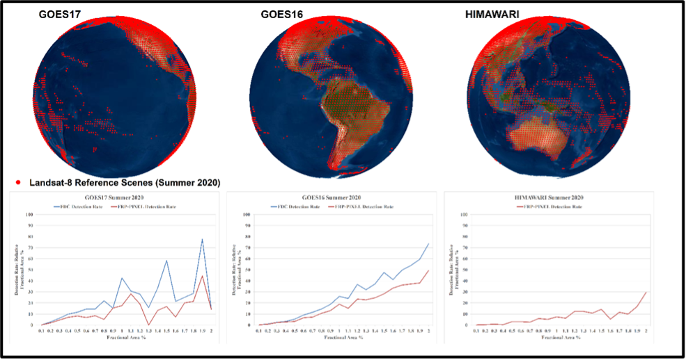
- Operational implementation of the production software for both the gridded and blended products on the internal computing cluster, and the consistent, rigorous validation of the underlying hemisphere-specific GOES-16 and -17 Fire Detection and Characterization (FDC) data and Himawari-8 fire data sets using more than 50,000 Landsat reference scenes.
- The Harmonized, Multi-Sensor Global Active Fire Data Sets is operational and is integrated into GWIS.