Imagen


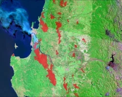
Tonlé Sap Lake, the largest lake in Southeast Asia, is a critical source of fish and freshwater resources for the region. The health of this freshwater system is under pressure from accelerating dam construction, intensifying agriculture, deforestation, and changing climate patterns, forcing tradeoffs between immediate food security and the long-term vitality and productivity of the ecosystem. Efficient freshwater system monitoring is crucial to navigating these challenges. In collaboration with Conservation International, the Cambodian Ministry of Water Resources and Meteorology, and the Tonlé Sap Authority, we developed and tested remotely-sensed proxies for sub-indicators of the Freshwater Health Index (FHI), which is typically calculated using in situ datasets. We used landcover datasets derived from Landsat 5 Thematic Mapper (TM), Landsat 7 Enhanced Thematic Mapper Plus (ETM+), Landsat 8 Operational Land Imager (OLI), PROBA-V Vegetation sensor (VGT), Sentinel-2 Multispectral Imager (MSI), Advanced Very High Resolution Radiometer (AVHRR), and Envisat Medium Resolution Imaging Spectrometer (MERIS) as inputs to calculate land cover naturalness and bank modification. Additionally, we created a lake-level time series using a collection of altimetry data sources to estimate deviation from natural flow. We observed a decrease in landcover naturalness and a breakdown in the volume and regularity of annual lake levels from 2000-2020, reflecting increased pressure on water supply and agricultural productivity. At least 8% of forested areas in the basin were lost and rice harvest intensity increased over the course of the study period. These results will help our partners make informed decisions regarding freshwater management. Furthermore, our remotely-sensed FHI analysis can be replicated in other regions, providing decision makers with a snapshot of freshwater health in data-scarce environments.