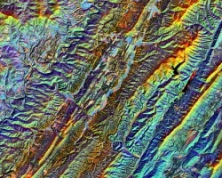
A rapidly warming Arctic has compromised the structural integrity of critical infrastructure through accelerated permafrost thaw and thermokarst development underlying these areas. Infrastructure, including roads, bridges, and airports across the state of Alaska are particularly at risk, as permafrost underlies ~85% of the state. However, monitoring the impacts of permafrost thaw on infrastructure is largely limited to in situ observations and frequently identified after the damage is evident. In order to assist transportation and infrastructure decision-makers in Alaska, this project identified and quantified areas of surface subsidence near critical infrastructure. Seasonal interferograms were created using Sentinel-1 C-band Synthetic Aperture Radar (SAR) and L-band Uninhabited Aerial Vehicle SAR (UAVSAR) data to identify areas experiencing surface deformation. Additionally, Light Detection and Ranging (LiDAR) datasets were used to validate select interferograms created between 2017 and 2019. Validation of subsidence detection across platforms was performed over a 7x8 sq. kilometer field site for 2017. The strongest relationship in spatial deformation is observed between Sentinel-1 and UAVSAR with a residual root mean square error of 20 mm. These results suggest that both UAVSAR and Sentinel-1 platforms are capable of detecting surface subsidence. The higher resolution of UAVSAR is better able to resolve localized subsidence features of less than 80 meters, but is limited by temporal resolution. In conjunction, UAVSAR and Sentinel-1 can provide complementary spatial and temporal resolutions for subsidence analysis in the absence of in situ data.
Related Impact