Imagen

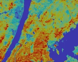
The Southern California coast, from Point Conception to the Tijuana River wetland, has become more sensitive to flooding as king tides have increased in magnitude. These king tides are thought to be intensifying due to numerous environmental factors such as storm surges, strong winds, and sea level rise as the result of a changing climate. Subsequently, king tides cause flooding along the southern coast, and it is predicted that the previously minor damages incurred from these tides will become more severe and hazardous to those who live on the coast. The US Geological Survey (USGS) Pacific Coastal and Marine Science Center has created their own flood prediction model, the Coastal Storm Modeling System (CoSMoS). The USGS currently uses their model to predict areas that may flood preceding a high tide and this project aimed to make the model more accurate by mapping landward extents. To do this, different remote sensing methods were used in conjunction with Earth observations such as NASA's Uninhabitated Aerial Vehicle Synthetic Aperature Radar (UAVSAR) and Landsat 8 Operational Land Imager (OLI). The team acquired imagery reflecting baseline tide levels and king tide events. The imagery underwent a change detection algorithm which produced a shapefile that highlighted areas most affected by extreme high tide events. The USGS Pacific Coastal and Marine Science Center will use this shapefile to validate their storm flood models, including the CoSMoS.