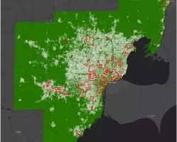
Cities are complex systems with interconnected “lifeline networks” enabled by critical infrastructure, which can be severely damaged or destroyed in the aftermath of a natural disaster. Following Hurricanes Maria and Katrina and the Tōhoku earthquake and tsunami, for example, damage to critical systems resulted in cascading effects that severely impeded recovery and crippled regional economies. Geographic information system data gives the location of critical infrastructure and can be used to identify and mitigate damage, but in many cases the locations of key components are unmapped or unshared, particularly in developing countries.
Without pinpointing the physical location of key assets, it is not possible to identify where the regional risk from infrastructure disruption can lead to cascading damage that, in some cases, could significantly reverse progress in developing countries. This project builds on previous work to expand the ability to model the catastrophic impacts of infrastructure disruption by providing a foundation for critical infrastructure exposure development in concert with remote-sensing Earth observations made via satellite.
The project team began its work in India, and expanded to developing countries globally, prioritizing based on end-user requirements. A city of focus, Vadodara, grew in massive numbers with COVID cases and was researched virtually. As with buildings, identifying lifeline networks is a data-fusion process requiring collection of existing datasets and use of segmentation and edge-detection algorithms. Data will be delivered openly and globally to developing countries and all those interested in risk, as well as integrated into commercial products for global risk identification and management.
During the early part of the project, the team received a supplemental grant from GEO-GEE Programme, a collaboration between the Group on Earth Observations (GEO) and Google Earth Engine (GEE), to access the Google Earth Engine platform. This forum creates greater access to the data necessary for risk identification.
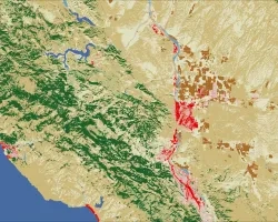
With the impact of the COVID-19 pandemic, the project team changed its methods to fulfill the project's requirements. Included in these changes was a transition to a virtual workshop. This team has progressed in establishing a connection and working with JBA Risk Management, identifying regions with the most significant economic risks from industrial and critical infrastructure dysfunction. In partnership with Kinetic Analysis Corporation, the team has analyzed the relative locations of the most considerable impacts to critical infrastructure.