Since year 2000, satellite observations are the primary data source for monitoring fire activity globally. The NASA MODIS MCD64 Global Burned Product is sufficiently mature to support policy making (i.e., national and subnational fire activity reporting and carbon inventories) but at the time our project was proposed - there was no service for systematic generation of summary fire activity information (i.e., maps, statistics, charts) specifically accessible to non-technical users. Therefore, this project developed a new module within the Global Wildfire Information System (GWIS) to provide global to sub-national science-quality information on fire seasonality, fire size, and annual rankings of fire activity, in easily accessible formats, derived from the NASA MODIS Global Burned Area Product using transparent, reproducible and documented methods.
Throughout the project our team consulted and engaged perspective users, by distributing pre-release version of the dataset and providing live demonstrations of the web application. This outreach was conducted through the collaboration with the Global Observations for Forest Cover regional partners, UN-FAO and AmeriGEO, and included product development / usage guidance for Bolivia, Guatemala, and Paraguay. The project is specifically focused on providing datasets and readily available fire information for the compilation of fire assessments and carbon inventories in Non-Annex I UNFCCC Parties, including least developed countries (LDCs), on account of their limited capacity and high vulnerability to climate change and natural disasters.
Key highlights include:
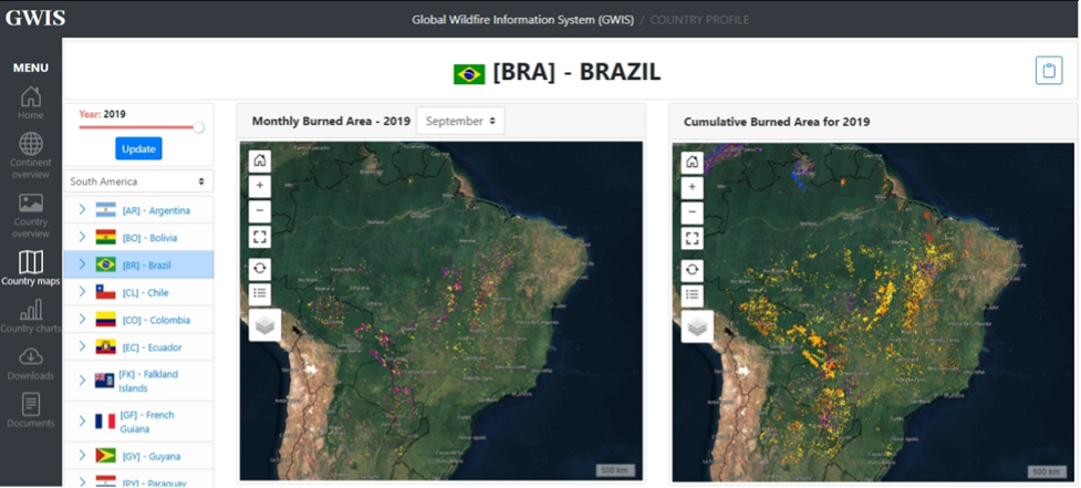
- In collaboration with the GWIS team at the Joint Research Center of the European Commission (JRC), successfully developed and deployed, the proposed new GWIS module - Country Profile Application. After extensive beta-testing, the system is now fully functional. The system allows users to interactively visualize maps of burned areas, tables and charts reporting fire activity metrics of area burned, number of fires, seasonality, fire size distribution. All source data area also available for download.
- Documentation, including a detailed user guide and a “quickstart” guide, has been developed to document the methods and to help users navigate the application. The application can be freely accessed at: https://gwis.jrc.ec.europa.eu/apps/country.profile/