Imagen
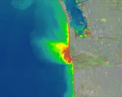
Weeks Bay is an estuarine system located along the southeastern shore of Mobile Bay in Baldwin County, Alabama. Its watershed encompasses approximately 149,000 acres of mixed-use land around the Fish and Magnolia Rivers. Weeks Bay and the surrounding coastal lands are currently protected as a National Estuarine Research Reserve (NERR) by the Alabama Department of Conservation and Natural Resources (ADCNR) and the National Oceanic and Atmospheric Administration (NOAA), but its watershed has been transformed from native forests and riparian land cover types to urban and agricultural areas over the last decade. These changes have resulted in increased stormwater runoff, flooding, soil erosion, and nutrient loading from the watershed into Weeks Bay. This project used NASA Earth observations from the Shuttle Radar Topography Mission (SRTM), Global Precipitation Measurement (GPM) Integrated Multi-satellite Retrievals for GPM (IMERG), and Landsat 7 Enhanced Thematic Mapper Plus (ETM+) along with ancillary data as inputs into the Soil and Water Assessment Tool (SWAT), which modeled the impacts of land use and land cover on water quality in Weeks Bay from January 2014 to January 2018 and forecasted possible future implications given continued land cover change. The SWAT model was also used to highlight sub-watersheds that impact water quality the most in order to prioritize them for conservation efforts. The outputs were then compared to a previous model created by an independent engineering firm that did not incorporate NASA precipitation data. The Weeks Bay NERR will use the findings of this project to support its watershed management and use of NASA Earth observations in future studies.