Hawai'i Island Climate (Summer 2022)
Team: Lisa Tanh (Project Lead), Ian Lee, Connor Racette, Matilda Anokye
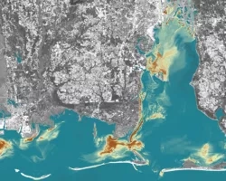
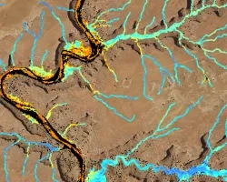
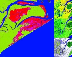
Summary: Climate-induced sea level rise poses a risk to coastal areas on the Island of Hawai'i, and many of the island’s historic cultural lands are in danger of becoming inundated. In partnership with the County of Hawai'i, the State of Hawai'i Department of Land and Natural Resources, and Arizona State University, our AZ NASA DEVELOP team modeled short-term sea level rise inundation risk and wetland extent. The team utilized NASA Earth observations over a 10-year span (2013–2022) that include data from the NASA MEaSUREs Gridded Sea Surface Height Anomalies (SSHA) and the Group for High-Resolution Sea Surface Temperature (GHRSST) to model sea level rise inundation risk. We used a random forest model to classify short-term inundation risk along the entire coast of Hawaii for five known local flood events from 2019 – 2021, using physically meaningful features like sea surface height anomalies and soil permeability. Additionally, the team compared the in-situ local tidal gauge data on two sides of Hawai'i Island to the SSHA data. Current wetland extents and probabilistic locations of new wetlands were modeled with data from PlanetScope Surface Reflectance optical imagery (2022), United States Geographic Survey (USGS) 3D Elevation Program 10m DEM (2013), temperature and precipitation data from the Hawaii Climate Atlas (2021), and soils data from the Hawai'i Soil Atlas (2014) using the Wetland Intrinsic Potential (WIP) tool. Results indicated locations with the highest probability of wetlands. Our project deliverables will assist our Hawai'i partners in evaluating short-term sea level inundation risk, meet regulatory requirements for wetlands protection, and guide decision-making for their Shoreline Setback and Climate Adaption plans.
Related Impact