Mississippi Embayment Water Resources (Spring 2022)
Team: Lauren Mahoney (Project Lead), Brenna Hatch, Lauren Webster, Claire Villanueva-Weeks
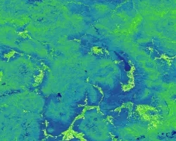
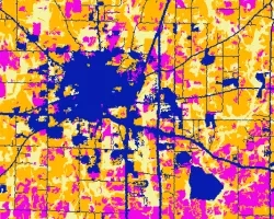
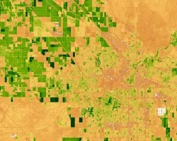
Summary: The Memphis Sand Aquifer (MSA) is located in the Mississippi Embayment which extends 250,000 square kilometers across nine states. Groundwater recharge factors that influence the narrow recharge zone of the MSA include precipitation, potential evapotranspiration, and landcover changes. The unsustainable water practices and increasing landcover change from urban development in the MSA's narrow recharge zone threaten the aquifer’s groundwater storage. In partnership with Protect Our Aquifer, the team used data from Terra Moderate Resolution Imaging Spectroradiometer (MODIS), Integrated Multi-Satellite Retrievals for Global Precipitation Measurement (GPM IMERG), National Land Cover Dataset (NLCD), and Gravity Recovery and Climate Experiment (GRACE). These datasets included annually-averaged precipitation, evapotranspiration, potential evapotranspiration, biannual landcover change, and monthly total water storage which were used to create groundwater recharge factors maps and time series. The evaporative stress index map, water balance map, and landcover change maps were used to identify thriving areas. . The team found precipitation did not express a strong linear trend and showed high precipitation years in 2017 and 2018, and a drought year in 2011. The potential evapotranspiration showed a weak negative linear trend. The landcover change showed shifts in forested areas and urban development. The team identified four thriving areas in the western side of Tennessee that successfully contribute to aquifer recharge due to increased forest area, sufficient water use, low changes in total water storage, and lateral positioning to streams. These end products allowed our partners to make informed decisions about areas that are thriving in the Mississippi Embayment recharge zone for conservation efforts of the aquifer.
Related Impact