Displaying 31 - 40 of 46
![Side by side photos of flooded Kennedy Space Center, one on the ground and one from space](/sites/default/files/styles/lis/public/2023-07/Kennedy.jpg.webp?itok=RonjzIH6)
Training Type
Level
Introductory
Date
Septiembre 19, 2023 - Septiembre 21, 2023
![Modeling Climate Risk Website Header](/sites/default/files/styles/lis/public/2023-08/Website_Header_Template.jpg.webp?itok=62G2NfsP)
Training Type
Level
Intermediate
Date
Octubre 03, 2023 - Octubre 10, 2023
![Modeling Climate Risk Website Header](/sites/default/files/styles/lis/public/2023-08/Website_Header_Template.jpg.webp?itok=62G2NfsP)
Training Type
Level
Intermediate
Date
Octubre 03, 2023 - Octubre 10, 2023
![Map displaying Oklahoma City Heat Vulnerability Index in 2020.](/sites/default/files/styles/lis/public/2023-09/Cheng_2020.png.webp?itok=cV1JbpSh)
Topic
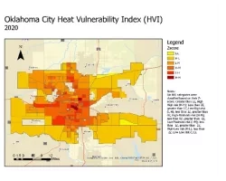
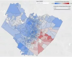
A spatial decision support system for identifying heat vulnerability based on a comprehensive energy budget model and multi-criteria decision analysis in Oklahoma City, OK Team...
DEVELOP
Wildland Fires
Climate
Capacity Building
Ecological Conservation
Health & Air Quality
Water Resources
![Kernel density distributions of census tract-level cooling degree days from May through September 2013 in Fahrenheit by race/ethnicity across the climate regions of New York State. Cooling degree days are calculated with a threshold of 65°. White = Non-Hispanic White, Hispanic = Hispanic/Latino of any race, Black = Non-Hispanic Black, Asian = Non-Hispanic Asian.](/sites/default/files/styles/lis/public/2023-10/Carrion%20Project%20Page%20Image.png.webp?itok=yyxxauFg)
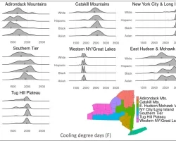
Identifying temperature disparities, energy insecurity, and social vulnerability for energy justice in New York State Team: Daniel Carrión (Yale School of Public Health), Anna Stouffer...
![Normalized Difference Water Index (NDWI) to visualize drainage networks around the Unalakleet River in Alaska, calculated from an August 2021 Landsat 8 OLI image. Yellow represents standing or flowing water and potential flood zones, while the dark blue represents drier, upland regions. Unalakleet's climate resilience planning prioritizes relocation to upland regions while avoiding areas that have experienced significant permafrost degradation.](/sites/default/files/styles/lis/public/2023-10/2023Sum_GA_UnalakleetClimate_WebsiteImage.jpg.webp?itok=9m9RUwoB)
Unalakleet Climate (Summer 2023) Team: Ian Lee (Project Lead), Clara Maxwell, Daniel J. Marsden, M. Jaweed Nazary Summary: The coastal community of Unalakleet is currently...
Affiliation
NASA HQ
Program Role
Program Manager, Climate Resilience and Community Action
Dr. Michelle Hawkins is the Program Manager for Climate Resilience and Community Action.
![Austin Multi-hazard Risk Index (flood + wildfire + heat + social vulnerability). The multi-hazard index previously computed utilized non-remote sensing, City-based data. An objective of the current project is to produce a similar index integrating remote sensing and socio-economic data. The current index shows there are clear spatial patterns with higher multi-hazard risk located in environmental justice communities in Austin.](/sites/default/files/styles/lis/public/2024-03/Climate%20hazard%20composite%20index.jpg.webp?itok=92aBbWp5)
Team Members: Dev Niyogi (University of Texas at Austin), Carmen Llanes Pulido (Go Austin, Vamos Austin), Marc Coudert (City of Austin), Sergio Castellanos (University of...
![Satellite Image of Himalayas](/sites/default/files/styles/lis/public/2024-03/Website_Header_Bhutan.jpg.webp?itok=sI6PdXqd)
ARSET - Building Capacity to Use Earth Observations in Addressing Environmental Challenges in Bhutan
Training Type
Level
Intermediate
Date
Mayo 13, 2024 - Mayo 16, 2024