Displaying 11 - 13 of 13
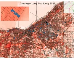
![Land surface temperatures for study area (Cuyahoga County, Ohio), as derived from Landsat. Black lines show boundaries of census blocks. Blue dots show the greenspaces and census blocks where the on the ground tree surveys have been conducted, with one census block highlighted as an inset. Image Credit: Rob Moore (Cleveland State).](/sites/default/files/styles/lis/public/2024-05/Mueller%20Project%20Page%20Image_0.png.webp?itok=nYl76fWk)
Topic
Team: Kevin Mueller (Cleveland State University), Brice Grunert (Cleveland State University), Thomas Hilde (Cleveland State University), Kaiguang Zhao (Ohio State University), Daniel Meaney (Cuyahoga County...
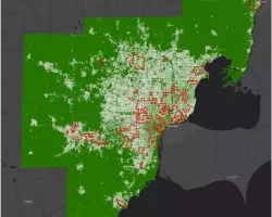
![Map of SEMCOG study area showing regions identified by SEMCOG as areas of persistent poverty, overlaid on a map of percent impervious surface for the seven county region.](/sites/default/files/styles/lis/public/2024-07/Miller%20Project%20Page%20Image.png.webp?itok=5Y_DbaH0)
Topic
Team: Mary Miller (Michigan Technological University), Michael Battaglia (Michigan Technological University), Laura Bourgeau-Chavez (Michigan Technological University), David Watkins (Michigan Technological University), Jessica Alger (Michigan Technological...
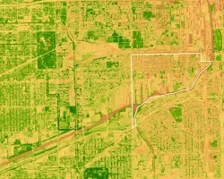
![2023_EEJwebpages -Saved SNSN Editing Editing Share Share: this file is shared Comments Catch up Undo There is nothing to redo. Paste Calibri (Body) 11 General Conditional Formatting Conditional Formatting Format As Table Cell Styles Cell Styles Insert Delete Format Sensitivity Add-ins P30 Normalized Difference Vegetation Index (NDVI) of the southwest side of Chicago from 2011 NAIP imagery. High levels of vegetation are dark green while low level](/sites/default/files/styles/lis/public/2024-08/Stuhlmacher%20Project%20Page%20Image_0.png.webp?itok=ntAKJM0E)
Topic
Team Members: Dr. Michelle Stuhlmacher (DePaul University), Dr. Winifred Curran (DePaul University), Dr. Marynia Kolak (University of Illinois, Urbana Champaign), Dajoin Williams (DePaul University), Christopher...