Displaying 61 - 70 of 473
![](/sites/default/files/styles/lis/public/images/develop-legacy/2017/spring/images/LRC-2017-E3-G_2017Spring_JPL_SantaMonicaMountainsClimate_TechnicalImage_00059.jpg.webp?itok=0SOmkV68)
Topic
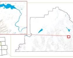
The Santa Monica Mountains stretch along the west coast of California between the coastal city of Oxnard and the populous urban hub of Los Angeles...
![](/sites/default/files/styles/lis/public/images/develop-legacy/2017/spring/images/LRC-2017-E3-G_2017Spring_MCHD_SoutheasternArizonaWaterII_TechnicalImage_00069.jpg.webp?itok=0xvlncRN)
Topic
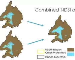
Southeastern Arizona is home to unique mountain ranges known as the Sky Islands. Sky islands are biodiversity hotspots and host various ecosystems, ranging from arid...
![](/sites/default/files/styles/lis/public/images/develop-legacy/2017/spring/images/LRC-2017-E3-G_2017Spring_ID.WC_SoutheasternIdahoWaterII_TechnicalImage_00055.jpg.webp?itok=6GxSwkT8)
Topic
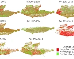
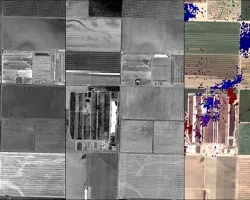
Understanding water dynamics in southeast Idaho is critical to planning and improving water management practices. Partner organizations that focus on water resource management, such as...
![](/sites/default/files/styles/lis/public/images/develop-legacy/2017/spring/images/LRC-2017-E3-G_2017Spring_UGA_SouthernAppalachiaDisasters_TechnicalImage_00067.jpg.webp?itok=19XxXjJb)
Topic
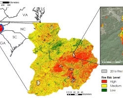
Wildfires in the southeastern US are less understood compared to other portions of the nation. In October and November of 2016, over 60 individual wildfires...
![](/sites/default/files/styles/lis/public/images/develop-legacy/2017/spring/images/LRC-2017-E3-G_2017Spring_WC_WyomingCross-Cutting_TechnicalImage_00068.jpg.webp?itok=sEnGyFnW)
Topic
Light pollution causes measurable damage to natural wildlife behaviors and human health, as well as decreases the ability for humans to view the night sky...
![](/sites/default/files/styles/lis/public/images/develop-legacy/2017/summer/images/LRC-2017-E3-G-2017Sum_LaRC_CALIPSO_Cross-Cutting_WebsiteImage_00093.jpg.webp?itok=h2kfQ5Pf)
Topic
The Cloud-Aerosol LiDAR and Infrared Pathfinder Satellite Observation (CALIPSO) satellite's CALIOP sensor generates vertical LiDAR profiles of the atmosphere at a global scale. Currently, the...
![](/sites/default/files/styles/lis/public/images/develop-legacy/2017/summer/images/LRC-2017-E3-G-2017Sum_JPL_CaliforniaHealthAQ_WebsiteImage_00090.jpg.webp?itok=mT8MOT6C)
Topic
Methane (CH4) is a potent greenhouse gas (GHG) with a lifetime of less than 10 years and a global warming potential that is 25 times...
![](/sites/default/files/styles/lis/public/images/develop-legacy/2017/summer/images/LRC-2017-E3-G-2017Sum_GSFC_ChesapeakeBayEco_WebsiteImage_00087.jpg.webp?itok=d2eZ69uU)
Topic
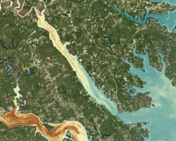
Tidal wetlands, such as marshes, are among the Chesapeake Bay's most protective natural features. Not only do they provide vital ecological services such as breeding...
![](/sites/default/files/styles/lis/public/images/develop-legacy/2017/summer/images/LRC-2017-E3-G-2017Sum_LaRC_ChesapeakeBayWaterII_WebsiteImage_00094.jpg.webp?itok=JuWzC0NM)
Topic
Submerged Aquatic Vegetation (SAV) is vitally important to the Chesapeake Bay, serving as one of the primary food sources for the organisms that inhabit the...
![](/sites/default/files/styles/lis/public/images/develop-legacy/2017/summer/images/LRC-2017-E3-G-2017Sum_ARC_ChilieWaterII_WebsiteImage_00081.jpg.webp?itok=FHRmCgzR)
Topic
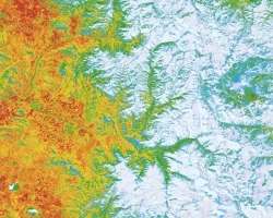
The Aconcagua basin of Central Chile, just north of the capital city of Santiago, is an arid region dominated by the Andes Mountains and heavily...