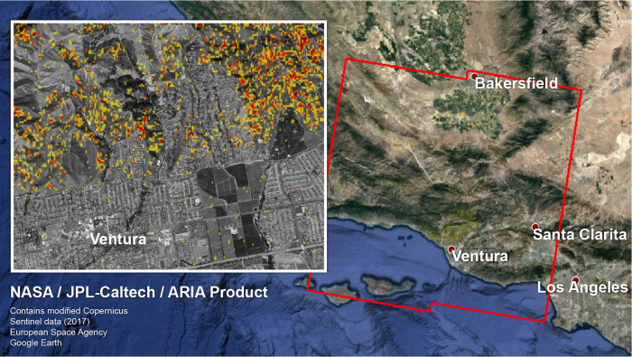
The Advanced Rapid Imaging and Analysis (ARIA) team at NASA's Jet Propulsion Laboratory in Pasadena, California, and Caltech, also in Pasadena, created this Damage Proxy Map (DPM) depicting areas in Southern California, including Ventura, that are likely damaged (shown by red and yellow pixels) as a result of wildfires. The map is derived from synthetic aperture radar (SAR) images from the Copernicus Sentinel-1 satellites, operated by the European Space Agency (ESA). The images were taken before (Nov. 28, 2017 6AM) and after (Dec. 10, 2017 6AM, both Pacific Standard Time) the onset of the fires.
The map covers an area of 107 by 107 miles (172 by 172 kilometers), shown by the large red polygon. Each pixel measures about 33 yards (30 meters) across. The color variation from yellow to red indicates increasingly more significant ground surface change. Preliminary validation was done by comparing to optical satellite imagery by the DigitalGlobe. This damage proxy map should be used as guidance to identify damaged areas, and may be less reliable over vegetated areas. For example, the colored pixels over mountainous areas may seem a little scattered even though the reality could be that the contiguous areas were burned. Patches of farm land can appear as signals due to plowing or irrigation.


