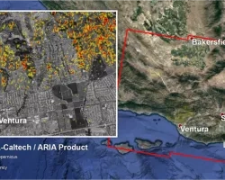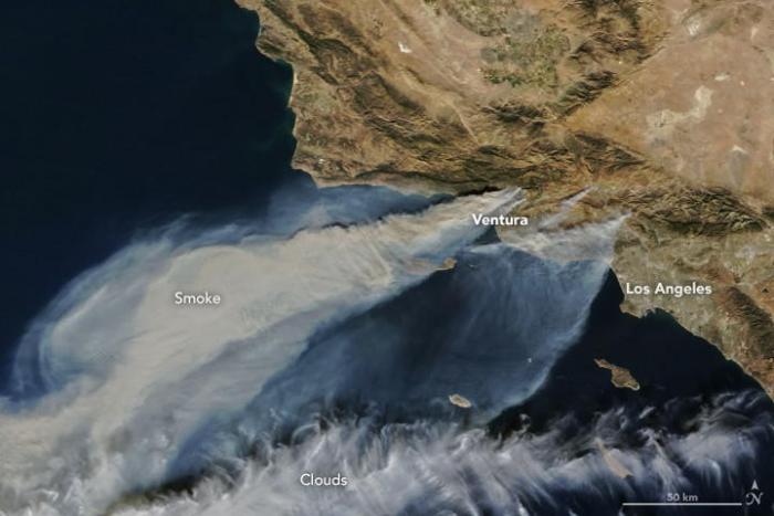
Another round of severe wildfires began burning in Southern California on December 5, 2017. These fires have prompted mass evacuations and consumed over 90,000 acres and 150 structures, and threated thousands of others. Key infrastructure and densely populated areas are threatened as the Santa Ana winds continue to fuel the fast moving fires. The NASA Disasters Program is closely monitoring these fires to determine how we may support.
Resources:
Basic information
- USDA Forest Service (USFS): The former Remote Sensing Applications Center (RSAC) is now Geospatial Service and Technology Center (GSTC): https://www.fs.fed.us/gstc/ & https://fsapps.nwcg.gov/
- CAL FIRE: http://www.fire.ca.gov/
- CAL OES Statewide: https://calema.maps.arcgis.com/home/item.html?id=660218d9469d46f9be467579cdb92c16
- Fire Situation Awareness: https://calema.maps.arcgis.com/apps/MapSeries/index.html?appid=33c284a58166427bab05a115414930ed
Portal to geographic regions and fire weather information
Ventura County Fire: http://vcfd.org/
Information about individual fires
Incident Information System: https://inciweb.nwcg.gov/
For viewing Earth, active fire and aerosol data
This site provides an excellent view of what is happening daily: https://worldview.earthdata.nasa.gov/
[zoom to area of interest and day, add layers, Fires, Fires and Thermal Anomolies, Aqua and Terrra (VIIRS too next), click data and night, close “X” search]
Active–Fire data
NASA active fire data (easy to use)
One can use these data to see the daily/hourly evolution and movement of fire hot spots. These data include ancillary information [e.g., Brightness Temperature, Fire Radiative Power (proxy for intensity)]
Available in text (ASCII) or shape files
https://earthdata.nasa.gov/earth-observation-data/near-real-time/firms
Forest Service (easy to use) – one can view or download. These are often satellite-based data.
https://fsapps.nwcg.gov/afm/gisdata.php
NOAA Hazard Mapping System Fire and Smoke Product:
http://www.ospo.noaa.gov/Products/land/hms.html
Burned area, severity, debris-flow modeling
NASA Applied Sciences Wildland Fire program
For post-fire analysis, one could use Landsat data (16-day return interval).
https://earthexplorer.usgs.gov/
RECOVER was designed as a Wildland Fire Decision-Support-System tool, however this system has been used for active-fire response to provide relevant data layers.
Keith Weber would be very happy for you to use RECOVER to assist with the California wildfires.
To request a fire web map:
-
Send an email to Keith Weber (webekeit@isu.edu )
-
Include a fire name (even “Fire01” will work)
-
Include some form of map data describing the area to be included in this RECOVER web map. Sending a shapefile works great.
We will generate the web map for you (the requestor) and send you the link ASAP.
When time allows, you can learn more about RECOVER by visiting http://giscenter.isu.edu/research/Techpg/nasa_RECOVER/index.htm
The USGS has predictions of debris flow for many Western fires already online:
https://landslides.usgs.gov/hazards/postfire_debrisflow/
You can also request they model fires that are not already posted!
Rapid Response Erosion Database
Mary Ellen Miller (memiller@mtu.edu) has a database for creating hydrological modeling inputs for predicting post-fire erosion and run-off and could help you learn the modeling if you want.
ESRI ArcMap information
This map shows accidents, traffic jams, road closures and fires (updated in minutes)
http://disasterresponse.maps.arcgis.com/home/group.html?id=d70f6493d8014371b15cb8f5ecab9ffe#overview
Air Quality
- Air Now: https://www.airnow.gov/
- NASA Health and Air Quality Applied Sciences Team (HAQAST): https://haqast.org/nasa-tools/
Other
https://earthdata.nasa.gov/fires-in-northern-california-usa
https://earthobservatory.nasa.gov/IOTD/view.php?id=91111
Live FMV on DAART for CA Fires
https://daart.us/Event/Details/840#
Specific to Northern CA fires
https://api.mapbox.com/styles/v1/robinkraft/cj8nn4lvp7yoq2ro1klhjltw8.ht...
Related Impact