The April 25, 2015 magnitude 7.8 Gorkha earthquake in Nepal produced a landslide dam on the Marshyangdi River, 1.1 miles (1,800 meters) upstream from the village of Lower Pisang. The dam has impounded the river, produced a landslide-dammed lake extending approximately 1,722 feet (525 meters) up the river, and satellite imagery shows that the lake area is expanding with time. Landslide dams can be inherently unstable and may fail suddenly, leading to possible flooding in low-lying areas downstream. The Annapurna Circuit trekking route follows the river on the east bank, although at a higher elevation than the river.
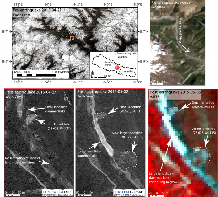
The upper-left map in the figure (Landsat 8 image from April 21, 2015) shows the Manang Valley. Yellow dots indicate new landslides identified and mapped as of May 6, 2015. The red box indicates the approximate extent of high-resolution satellite imagery shown in the bottom panels.
A pre-earthquake (April 21, 2015) Landsat 8 image (upper-right) shows the Marshyangdi River to be flowing unrestricted. A series of bank-failure landslides appear in the post-earthquake high-resolution WorldView-2 satellite imagery from April 27, 2015, two days after the earthquake, between Humde and Lower Pisang on the Marshyangdi River. Most of these do not appear to be blocking the river, but seem to have caused minor localized reduction in flow and ponding upstream. A subsequent WorldView-2 satellite image taken five days later on May 2, 2015, shows a new, larger landslide (approximately 656 feet, or 200 meters, wide by 623 feet, or 190 meters), which appears to almost entirely block the river, about 1.1 miles (1.8 kilometers) upstream of the village of Lower Pisang. This landslide dam is likely responsible for creating a lake that at the time the satellite image was acquired on May 2, 2015, was approximately 1,722 feet (525 meters) long and up to 230 feet (70 meters) wide. The imagery also appears to show a small channel draining the lake at its southernmost end.
A WorldView-2 satellite image acquired on May 5, 2015, while not showing the landslide dam and lake, shows the village of Lower Pisang with no obvious flood-related damage, suggesting that the dam and lake were still intact, or that the lake had begun to drain without causing a flood. On May 6, 2015, a medium-resolution image from the Advanced Spaceborne Thermal Emission and Reflection Radiometer (ASTER) instrument on NASA's Terra satellite showed that the dam had not yet breached, but the lake had likely increased in size since the earlier images.
Given that the lake area has likely increased over time, it appears that the amount of water coming into the lake exceeds the amount drained through the landslide dam, so this lake poses a potential threat to Lower Pisang and villages downstream. The formation of this landslide dam and lake two or more days after the primary shock of the Gorkha earthquake is a pointed example of the secondary hazards existing in the earthquake- and aftershock-affected region.
A high-resolution download of the map and satellite data is available at: http://web.uvic.ca/~dshugar/28625_84135_PISANG_Annapurna_Shugar_NASA_UVic.png


