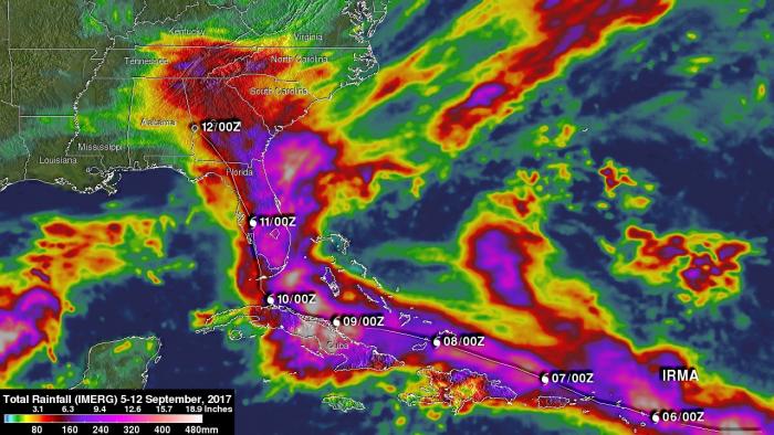
Hurricane Irma dropped extremely heavy rain at times during it’s trek from near the Cape Verdi Islands through the northern Leeward islands, Cuba and the southeastern United States. Over 16 inches (406 mm) of rain was reported in Guantanamo, in the easternmost province of Cuba, as the category five hurricane battered the country. Almost 16 inches (406 mm) of rain was also reported at Fort Pierce on the eastern side of Florida. Charleston, South Carolina reported 6 inches (152.4 mm) of rain in 24 hour. This heavy rainfall plus storm surge flooding caused the worst flooding in Charleston since hurricane Hugo hit the state in 1989. Today, hurricane Irma is a remnant low over the Tennessee valley. The National Hurricane Center (NHC) stopped issuing advisories on Irma on September 11, 2017 at 11 PM EDT (0300 UTC).
NASA's Integrated Multi-satellitE Retrievals for GPM (IMERG) data were used to estimate the total amount of rain that Hurricane Irma dropped from September 5 to early September 12, 2017. During that period Irma dropped heavy rain along it’s path from the Leeward Islands until dissipation over the southeastern United States. Rainfall totals were often greater than 6 inches (152.5 mm) around Irma. The greatest IMERG rainfall estimates were indicated by more than 20 inches (512 mm) over Cuba.
Instrument / Model: IMERG


