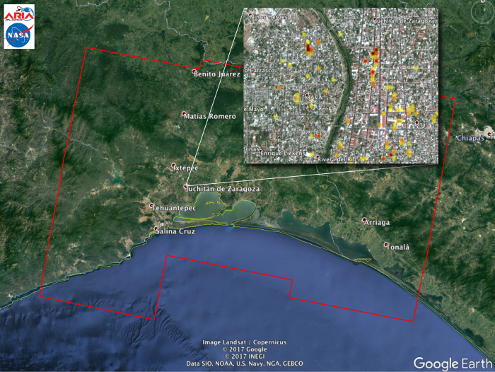
The Advanced Rapid Imaging and Analysis (ARIA) team at NASA's Jet Propulsion Laboratory in Pasadena, California, and the California Institute of Technology in Pasadena, created this Damage Proxy Map (DPM) depicting areas of Southern Mexico that are likely damaged as a result of the M8.1 September 7, 2017 (near midnight local time, early morning on 8th UTC) Chiapas earthquake, shown by red and yellow pixels. The map is derived from synthetic aperture radar (SAR) images from the Copernicus Sentinel-1A and Sentinel-1B satellites, operated by the European Space Agency (ESA), taken before (September 7, 2017 UTC) and after (September 13, 2017 UTC) the earthquake. The map covers an area of 155 by 106 miles (250 by 170 kilometers). Each pixel measures about 33 yards (30 meters) across. The color variation from yellow to red indicates increasingly more significant ground surface change. Preliminary validation was done by comparing to optical satellite imagery by the DigitalGlobe. This damage proxy map should be used as guidance to identify damaged areas, and may be less reliable over vegetated areas. Sentinel-1 data were accessed through the Copernicus Open Access Hub. Image contains modified Copernicus Sentinel data (2017), processed by ESA and analyzed by NASA-JPL/Caltech ARIA team. This research was carried out at the Jet Propulsion Laboratory, California Institute of Technology, under a contract with the National Aeronautics and Space Administration.pernicus Sentinel data (2017), processed by ESA and analyzed by NASA-JPL/S.Yun (Project PI under NASA Disasters Program). Data processing: NASA-JPL/Caltech ARIA team.


