“Knowledge is power and we can use that power for social good.” - Diego Melgar
Why Tsunamis?
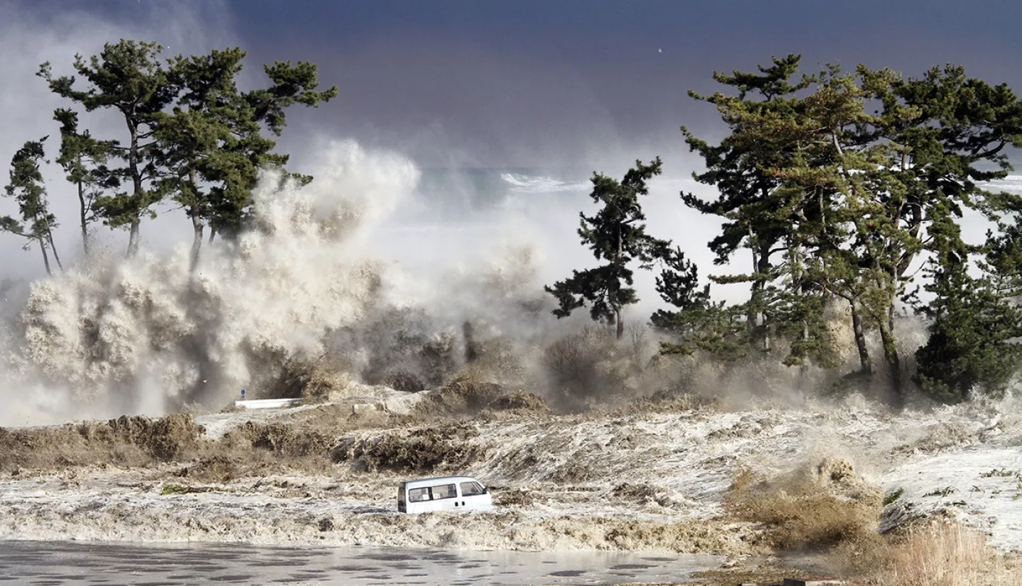
In 2011, Japan’s Tōhoku earthquake and tsunami permanently altered the course of Diego Melgar’s research. At the time, Melgar was a doctorate student at Scripps Institution of Oceanography looking at how researchers could use Global Navigation Satellite System (GNSS) data to study earthquakes. In doing so, more lives could be saved when earthquakes strike. However, in the aftermath of the magnitude 9 Tōhoku earthquake, Melgar realized that roughly 90-95% of the casualties were not caused by the quaking, but by a catastrophic tsunami that occurred immediately after the earthquake. Japanese residents didn’t receive the tsunami warning fast enough, and after ten minutes it was too late for them to flee. Prior to the event, Melgar hadn’t given tsunamis much thought, but afterwards it was clear to him that there is a need for local tsunami early warning systems. So, he shifted his focus from earthquakes to tsunamis and educated himself on tsunami modeling.
Working with NASA’s Disasters Program
Melgar originally developed an interest in NASA through his PhD advisor – a scientist whose research was funded through NASA. After completing a NASA graduate fellowship, he eventually moved to a faculty position where he discovered that NASA was looking for solutions to the same problems as himself. To Melgar, collaborating with the NASA Disasters program seemed like a natural avenue to continue to pursue his research goals.
Currently, he is the principal investigator for the NASA A.37 ROSES research project “Tsunami Early Warning with GNSS Earthquake Source Products,” which aims to provide tsunami warning for the Cascadia subduction zone within the first five minutes after an earthquake. The Cascadia subduction zone is a 600 mile fault that stretches from northern Vancouver Island to northern California and experiences a heightened rate of earthquakes and tsunamis. According to Melgar, if a magnitude 9 earthquake were to occur in the Cascadia subduction zone today, very limited information would be available within the first five to ten minutes after the event about the potential magnitude and arrival time of tsunamis. Melgar’s goal is to work with NOAA to develop early warning technology and put that technology into the warning centers – the Pacific Tsunami Warning Center (PTWC) and the National Tsunami Warning Center (NTWC) – so that they can notify communities of potential tsunamis sooner.
In the long term, Melgar would like to broaden the base of his work to worldwide local warning so that the PTWC and the NTWC could be used to issue warnings for all regions of the world with access to GPS networks. Ideally, he would like to see GPS being used for local warning everywhere around the world within ten or twenty years from now or sooner if possible.
Current Work: La Crucecita Earthquake and Tsunami
On June 23rd, 2020 a 7.4 magnitude earthquake occurred offshore of Oaxaca, Mexico. The location, magnitude and depth of the earthquake created the conditions necessary to cause a tsunami, leading to a tsunami warning being issued for the Pacific coasts of Mexico as well as Central and South America. While the tsunami’s impacts were minor, the event provided researchers with an opportunity to test the performance of the tsunami forecasting and early warning system developed by Diego’s research project.
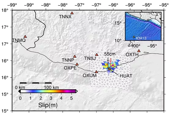
Melgar generated a slip model and an expected vertical deformation model to serve as guides for collecting measurements and observations of tsunami signals in the field. Since tsunami signals start to diminish with rain or human disturbance, the teams that conduct post-event tsunami surveys need to deploy within a week after the event or sooner. Because of this, they rely on these models to provide them with a rough estimate of what they are looking for in a particular area to prevent them from wasting valuable time.
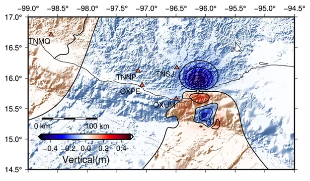
In the long term, these detailed models, which are created after a natural hazard has been processed, are then used to compare with real-time models to determine the accuracy of the real-time models. Melgar’s project will continue to use hazards such as the earthquake in Mexico as opportunities to improve the tsunami forecasting and early warning system, and to provide life-saving information to decision makers as quickly as possible.
Motivation to Work
When asked about what motivates him to continue working, he claimed that although earthquakes destroy cities and ruin lives, there is something awe inspiring and incredibly interesting about them. “In a sense I equate it to looking at fire. We look into a fire and obviously it burns and it hurts, but it’s still really interesting to see what’s going on there. I have that same sort of relationship with earthquakes.” Earthquakes may be extremely dangerous, but his interest in learning more about how to help communities outweighs the potential risks. “Knowledge is power and we can use that power for social good.”
Melgar also enjoys the social relevance aspect of his work. Providing people with an early tsunami warning can affect the lives of thousands of people at a time, if not more. However, he says that it also fills him with dread to have that kind of responsibility – the responsibility of creating something that can save lives if it works but can have catastrophic effects if it fails. “This keeps me up at night.”
The Challenges of Being a Scientist
According to Melgar, one of the most challenging aspects of being a scientist has nothing to do with science or technology. Instead, it’s adapting to a nomadic lifestyle for roughly a decade. Melgar moved from Mexico to the United States to obtain his graduate degrees in geophysics, leaving behind his entire family and partner at the time. And after working on his PhD for five years in San Diego, he had to move again to Berkeley to pursue a research opportunity before finally relocating to the state of Oregon where he currently lives. “It’s just continuous moving for probably about a decade before you can finally land in a place that you can call home for the long term, and that’s really challenging for interpersonal relationships… [and] for just building a life.”
In the next ten years or so, Melgar would like to see more modern data science techniques and machine learning play a role in the mainstream response to disasters and hazards. However, in the near future, Melgar will be graduating his first PhD students and helping them land on their feet as independent scientists in their own research programs.


