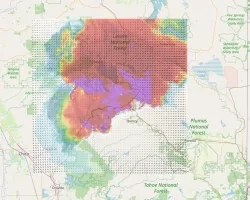
Tsunamis are one of the most powerful and destructive natural forces. Triggered by earthquakes, tsunami waves typically reach shores anywhere between 15 to 30 minutes after a quake occurs. Current tsunami early warning systems in the Cascadia subduction zone struggle to respond within the first crucial five minutes post-earthquake, leading to needless deaths.
Diego Melgar is addressing this problem with his NASA Applied Sciences A.37 ROSES project. The project is working with NOAA to develop early warning technology and to put that technology into two warning centers, the Pacific Tsunami Warning Center (PTWC) and the National Tsunami Warning Center (NTWC), so that they can respond within those critical first five minutes. The project uses an algorithm that delivers real-time estimates of an earthquake’s magnitude, geographic extent and details of the amount of motion (slip) on a fault. Currently, the algorithm is deployed at the NOAA Center for Tsunami Research (CTR) and is receiving satellite data from over 1,000 sites worldwide.
Full Description
Compared to other natural hazards such as hurricanes or forest fires that annually propagate, large tsunamis are infrequent. As a result, over the last 50 years as digital geophysical instrumentation has matured, local tsunami warning systems that alert the coastlines immediately adjacent to a large event have not been a priority of national or international monitoring agencies. The incidence of return periods of large events are usually measured in many decades to centuries. Thus, local warning systems do not exist in the majority of countries located along subduction zones, including the United States. However, recent events in Indonesia, Chile, and Japan, have shown that despite their comparative rarity, tsunamis can lead to substantial casualties, potentially tallied in the tens to hundreds of thousands of lives, as well as to the total economic collapse of the affected regions.
Compounding the problem are steady increases in population in tsunami-prone areas over the last 25 years. Because evacuation start time is the most important variable in tsunami mortality rates, rapid tsunami information systems that forecast intensities at the local level in the first 5 minutes are essential in providing actionable information to emergency responders and decision-makers to order evacuations in the affected regions as quickly as possible. All of these elements make the development of a rapid and accurate local tsunami warning methodology, and its implementation, a pressing issue which we propose to help solve in this work.
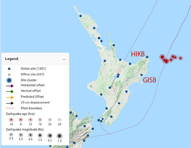
The use of Global Navigation Satellite System (GNSS) displacement data in the near-field is a paradigm-shifting technology thanks to its ability to track the motions of large earthquakes without going off-scale. Real-time, high-data-rate GNSS networks are currently operational in many countries around the Pacific Rim. These networks were originally installed to measure long-term tectonic motions, and over time, were upgraded with higher sample rate receivers and robust telemetry. Because of this, these networks are primed to both record long-term tectonic motions and strong ground motions from nearby great earthquakes, oftentimes with greater spatial density than complementary seismic networks.
We will modernize near-field (local) operational tsunami forecasting and early warning through the addition of GNSS-derived earthquake source products and the seamless connection to already existing NOAA tsunami modeling codes. Extensive testing, both online and offline, will be performed using historical and synthetic earthquake datasets. These tests will help to guide modifications in the software and familiarize practitioners with the strengths and limitations of the different codes. Finally, using lessons learned, we will work with partners in Chile and New Zealand to guide them through the process of an operational GNSS-enabled tsunami early warning system.