Sang-Ho Yun, a geophysicist at NASA’s Jet Propulsion Laboratory (JPL) has maintained a passion for the Earth since he was young. Early on, he also developed an interest in physics. Physics, he says, is “simple, beautiful and scalable.” Physics is a foundational framework that we can use to understand our universe and, for Yun, the dynamic, ever-changing Earth. Yun first studied Earth science at Seoul National University, where he also went on to receive his Master of Science degree. It was during his studies for his master’s degree that he also gained an interest in remote sensing and radar. From there, he went to Stanford University to receive his PhD in geophysics, specializing in remote sensing using radar.
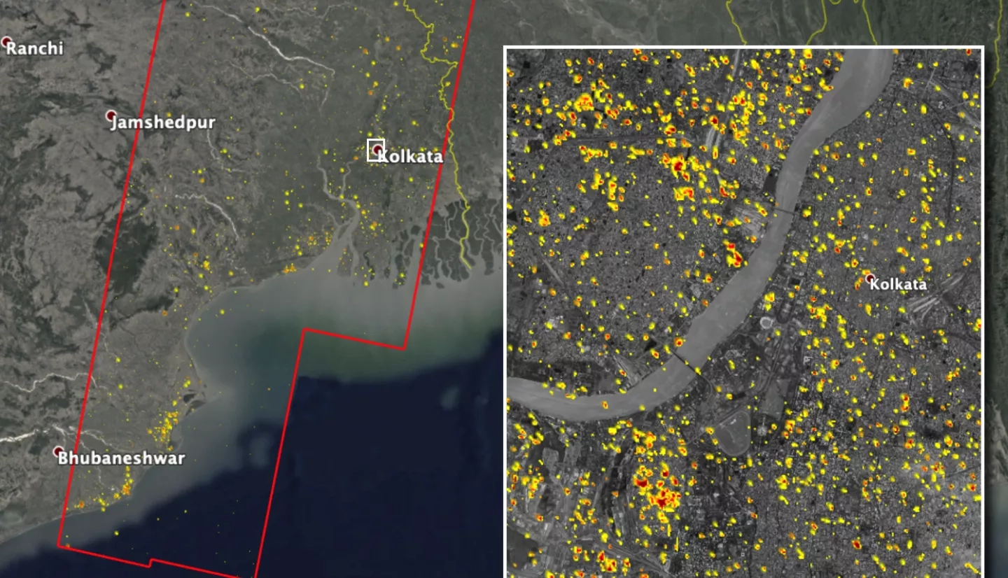
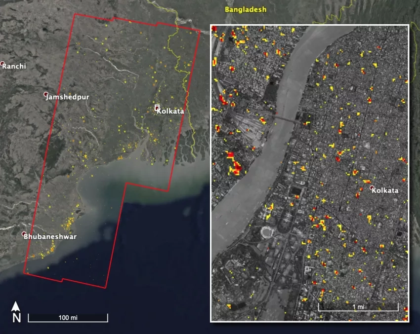
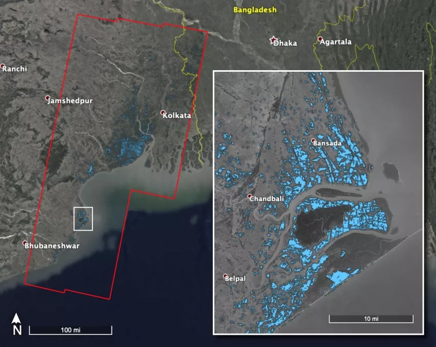
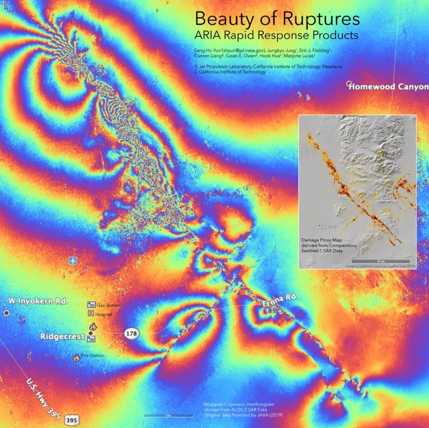
After completing a postdoc with the United States Geological Survey (USGS) Yun accepted a job at JPL, where he was later approached to be a member of Advanced Rapid Imaging Analysis (ARIA), a project that brings Earth-observing satellite radar observations, GPS and other data to hazard science and response. Since then he has actively played a leading role in the ARIA project, in charge of damage and flood mapping using satellite radar data for disaster response. This application of satellite radar data applies the technologies he specialized in for his PhD thesis, which involved incredibly detailed measurements of ground deformation around volcanoes – down to millimeter-scale levels of change in ground elevation. Considering Yun’s technological expertise it is no surprise that he plays a crucial role in ARIA, which utilizes similar radar technologies to create damage proxy maps (DPMs) and flood proxy maps (FPMs) that detect changes caused by disaster events such as earthquakes and floods. Yun and the NASA Earth Applied Sciences Disasters program use these valuable maps from ARIA to aid decision-makers in response efforts to disasters all around the world.
ARIA for the Disasters Program
ARIA utilizes Synthetic Aperture Radar (SAR), which is a form of high-resolution imaging radar that penetrates clouds and provides images during both day and night. Using this SAR data ARIA acquires, processes and produces products using Amazon cloud computing services. These products are then delivered to stakeholders and decision-makers following disaster events in multiple ways, including the NASA Disasters Program Mapping Portal. Through this process, ARIA provides data products with impressive speed and accessibility to decision-makers and responders after a disaster strikes. ARIA’s products provide an unparalleled level of efficiency that is crucial to timely damage assessment and strategic response efforts.
What is the ultimate goal of Yun’s work with ARIA for the NASA Disasters program? He says that there are many “tiers of goals” to his work, especially technically – but ultimately, Yun admits that he wants to save lives. To do so, he works to make ARIA “rapid enough, accurate enough, and reliable enough, so that first responders can actually use this kind of information to save people’s lives.”
He also describes how ARIA’s beneficial impact can be taken further to make a society more resilient. He explains that while response to disasters is crucial, implementing preventative measures that help mitigate future impacts of disasters is even better, preemptively reducing the level of damage that will occur. Using data from ARIA and collaborations with other agencies, “We can better prepare for the unavoidable.” Resources like ARIA are growing and improving, but the problem of disaster response and resilience remains an extremely complex process.
Amphan Response and Lessons from Vanuatu
In April 2020 Tropical Cyclone Harold struck the Pacific island country of Vanuatu (along with Fiji, the Solomon Islands and Tonga) where it caused widespread damage due to high winds and heavy rainfall. ARIA collaborated with the Earth Observatory of Singapore (EOS) to provide the United Nations World Food Programme (WFP) with data products to assist their response efforts. The damage proxy maps that ARIA produced were used to estimate the number and location of damaged buildings and the resulting number of people affected. The WFP then used these estimates to plan and deploy relief efforts to the affected locations and populations. This data proved valuable to the WFP, so when another cyclone, Amphan, devastated parts of India and Bangladesh when it made landfall on the 20th of May 2020, ARIA was contacted again by the WFP.
The working relationship with the WFP and the techniques used during the Vanuatu relief efforts benefited and informed response efforts in India and Bangladesh. Yun explains that disaster response occurs rapidly, with no time to build new relationships or test different methods, so working relationships expedite and advance each response. Where timing and efficiency is critical, ARIA and Yun’s expertise are deeply appreciated, and Yun’s team is always listening for feedback and new means of further improving ARIA’s products.
Improving the Disaster Response Process
When asked about what he would change in order to improve the disaster response process, Yun said that the goal was to “figure out how to do the same thing but faster for the next event.” He is currently working on building a system that would reduce the amount of manual labor necessary when responding to an event by automatically searching for and processing the relevant data in a given situation. This would allow local agencies to make decisions quicker and with higher accuracy than before, minimizing the latency and possibly saving lives.
Another way to improve the response process is to collect feedback from the responding agencies about the data, for example: did the data underestimate or overestimate the damage done to an area? Since the ultimate goal is to make these maps useful, it is important to know which aspects of the map the agencies found to be the most and least helpful in their decision-making processes, and therefore know what areas need to be improved for the next time. According to Yun, collecting feedback from the decision makers is one of the most overlooked yet important factors in responding to an event. In doing this, ARIA can continue to constantly evolve and improve their maps for future use.
Creating Art Through Science
A little-known fact about Yun is that he originally wanted to be an artist before he decided to be a scientist in his early elementary school years. Instead of choosing one passion over the other, he chose to combine his early artistic talents with his science career. He stated that “within the science career you have an equal range to be creative,” and he even described the process of creating a ground deformation map as using scientific data to create a piece of art.
Yun continues to use his artistic abilities whenever possible, and even designed the official NASA Disasters program logo along with the ARIA logo and the upcoming NASA-ISRO Synthetic Aperture Radar (NISAR) mission logo. The NISAR mission is a project between NASA and the Indian Space Research Organization (ISRO) to create and launch a dual-frequency synthetic aperture radar on an Earth observation satellite.
Looking Toward the Future
Moving forward, Yun claims that the next major issue that he hopes to tackle has less to do with the response process and more to do with the recovery process that follows. As of right now, there are maps that show the effect of disaster events, but they are only used to assess the extent of damage that has occurred. Yun’s goal is to create a map that helps assess the post-disaster needs of an area by comprehensively monitoring the recovery phase at the disaster-hit areas using a number of radar images over extended period of time. Yun says these new maps will be useful not just for the rapid assessment of a situation immediately following the disaster, but also for assisting the rebuilding efforts in the months that follow.
