Have you ever planned a day of fishing or swimming at the lake only to have your plans dashed by slimy green water? Often you were looking at a cyanobacteria bloom. Blake Schaeffer monitors these unsightly and sometimes dangerous blooms. He is a research scientist at the United States Environmental Protection Agency (EPA) and at the forefront of applying NASA Earth-observing satellite data to the problem.
When the cyanobacteria population increases a lot it is called a "bloom." In some cases, these blooms release toxins that can make people, pets and livestock sick. During the last year of COVID-19 restrictions on indoor activities, more people flocked to outdoor recreation spots, pushing into the forefront the years of work Schaffer and his team have spent tracking these blooms.
Schaeffer recognized one of the challenges state and local officials had in issuing health advisories before the public could be exposed was the time it took to monitor the large spatial range of lakes and reservoirs. He saw an opportunity to speed up the process — and keep the public safer.
In October 2015, Schaeffer assembled a team from EPA, NASA's Goddard Space Flight Center, the National Oceanic and Atmospheric Administration (NOAA) and the United States Geological Survey (USGS) to build and pilot a satellite remote sensing network of collaborators.
Called the Cyanobacteria Assessment Network (CyAN), their goal was to use satellite remote sensing data to help fill the gap in real-time knowledge on cyanobacteria related health and safety of America’s lakes and estuaries.
“It’s not every day you can say that you can monitor something happening across your nation or within your state and really have a good understanding of what’s happening,” Schaeffer said.
But that’s exactly what CyAN does. It assesses bodies of water and provides real-time data to state and local officials, helping them make informed decisions on where to focus their limited time and capacity for testing and mitigation efforts. Since launching CyAN, Schaeffer and his team have expanded their monitoring to cover over 2,000 of the largest lakes in the contiguous US, recently adding Alaska, and engaged with 33 state departments of health or environment to show them how to use CyAN for their needs. Their hard work is starting to see some serious results.
CyAN has saved millions of dollars in monitoring and healthcare costs and established Earth data as an invaluable ally in the fight to get ahead of harmful algal blooms (HABs). Schaeffer’s work on CyAN has gained global recognition as well. In February 2021, the World Health Organization updated their guidance on HABs to include the use and consideration of satellite data.
How Schaeffer Uses Earth Data to Identify Algal Blooms
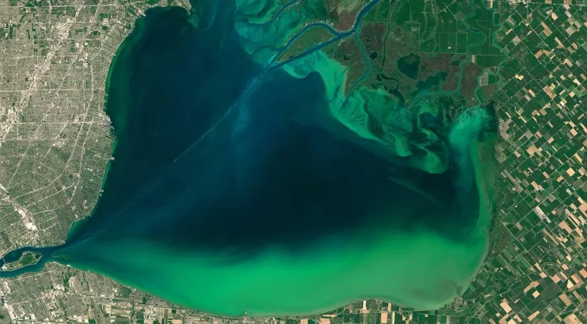
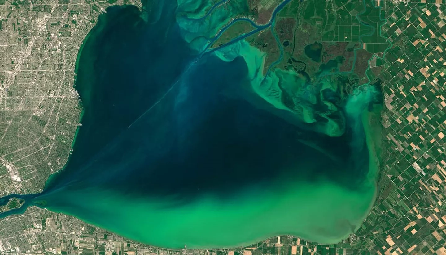
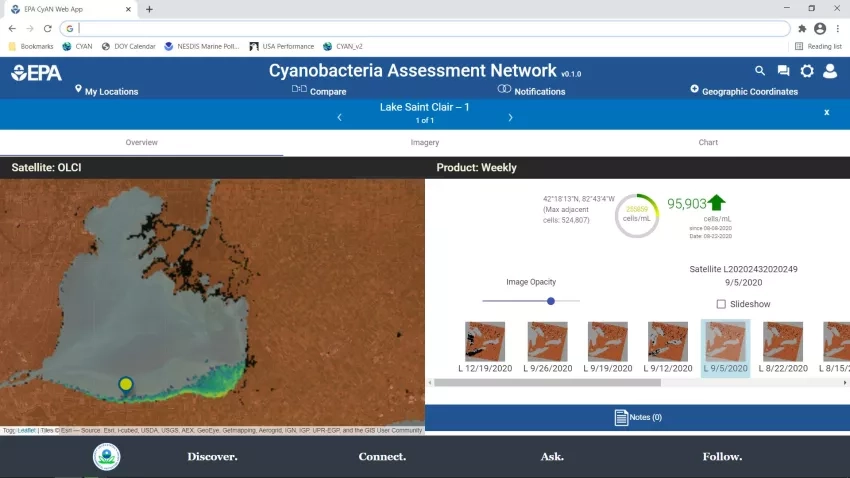
CyAN works much like how your eyes can pick up on color differences in the water. It combines satellite data with mathematical algorithms to process images of bodies of water and determines just how much cyanobacteria are present, how much sediment is causing certain colorations and more, Schaeffer explained.
Every day, NASA Goddard Space Flight Center in Greenbelt, Md. processes satellite imagery from satellites like the European Space Agency’s Sentinel-3 for CyAN and pushes the data out to the people who need it. This helps everyone from water quality offices to vacationers make data-driven decisions on whether a health advisory or mitigation strategy is needed, or whether a recreationist should rethink their fishing plans.
Aaron Borisenko, a water quality monitoring manager at Oregon Department of Environmental Quality, explained how CyAN helped protect vulnerable populations in Salem, Ore. during a drinking water advisory in 2018.
“CyAN allowed us to see when and where blooms were forming and helped us communicate to our drinking water provider partners the status the HABs conditions on the lake, so they had more information to tailor their monitoring and treatment options,” Borisenko said.
Similarly, Schaeffer’s work helped Utah get ahead of a harmful algal bloom so they could conduct early sampling and issue health advisories before the public became exposed. “Without the imagery available through CyAN, the state would not have realized a bloom was already starting on the lake,” said Tina Laidlaw, a nutrient and HABs coordinator and environmental scientist at EPA.
Success didn’t happen overnight, though. It took Schaeffer and his team quite some time to understand monitoring needs. They worked closely with collaborators at different state and environmental health departments to understand their pain points both generally and in using CyAN and adapted to solve for those challenges.
When Schaeffer and his team put out the call for beta testers during this process, EPA’s Pacific Northwest Region’s Water Division was one of CyAN’s early adopters. Rochelle Labiosa, a water quality scientist at EPA, expressed appreciation for their consideration of user needs.
“Blake is not only a great scientist, but he is a great communicator and also anticipates the needs of state, tribal and local regulatory agencies,” she said. “The fact that he and his collaborators worked quickly to release an app to provide information access to the public, with a focus not just on researchers, attests to this. He also is an out-of-the-box thinker and isn’t daunted by the challenges inherent in remote sensing of inland waters — finding the niche for the appropriate interpretation and application of the data.”
Many other CyAN collaborators have also expressed gratitude for Schaeffer’s openness to feedback and passion for communicating his work in ways that engage his audiences, getting them to care about and understand his work.
“As CyAN’s project manager, Blake has done an outstanding job in engaging those working with harmful algal blooms in EPA and other federal agencies to actively participate in the development of the project, and by acknowledging their feedback to make sure CyAN meets EPA and the states’ needs,” said Lesley D’Anglada, a senior microbiologist at EPA’s Office of Water.
Why Earth Data Matters for HABs Detection
There are thousands of lakes, ponds and estuaries in America — too many for state and local officials to regularly sample. But satellites have the ability to be everywhere, and can observe bodies of water that humans don’t have the resources to travel to and alert them to a potential bloom well before water test results come back.
The Oklahoma Water Resources Board has been able to free up significant personnel resources since working with CyAN. Weekly monitoring of Oklahoma’s 53 lakes was unrealistic for their program, but now, “for the first time ever, we can observe the frequency and extent of high cyanobacteria events occurring in lakes across the state,” said Rebecca Veiga, an environmental program manager.
“We now have reliable and consistent information, as opposed to sporadic or anecdotal observations, on cyanobacteria blooms, which allows informed conversations with stakeholders and decision makers,” she said. “I am so grateful for [the work of Blake and his team] in making NASA Earth data available to state scientists with direct responsibilities for water quality protection and management decisions.”
The COVID-19 pandemic has put the benefits of using Earth data into even clearer focus. At the onset of the pandemic, Schaeffer questioned the urgency of his work in comparison to the other issues states were facing. “I felt like our work needed to take a back seat and other things were going to take priority as they should,” he said. Imagine his surprise when offices began requesting satellite monitoring with increasing frequency.
“A lot of states couldn’t travel like they used to in order to do the traditional sampling,” Schaeffer continued. “They needed a way to assess the water because people were still going to these lakes to recreate — probably even more so because they were limited in what they could do during the pandemic.”
EPA’s Midwest Region was one of the many areas experiencing limitations due to COVID-19. Laura Webb, a chemist at EPA Midwest’s Laboratory Services and Applied Sciences Division, said that Midwest states relied on CyAN imagery to track the severity of HABs in reservoirs that COVID-19 prevented them from routinely monitoring.
The Idaho Department of Environmental Quality also uses CyAN to reduce the number of trips staff take to visually monitor and sample lakes. They even used CyAN data to release a potential bloom map that keeps the public informed about what cyanobacteria is and where it may be popping up around the state.
Like the above-mentioned end users who spoke to the value of Schaeffer’s work, water quality, health and environmental officials use CyAN in different ways to solve their unique challenges in monitoring algal blooms. And that’s exactly how Schaeffer envisioned CyAN working. As part of the Applied Sciences Program, Schaeffer said, “our ultimate goal is to get this into the hands of users and allow them to take on the forward momentum of using the information for themselves.” The many ways that states — and now the World Health Organization — have incorporated satellite data into their HABs response plans is a clear sign that the momentum is building. And people, pets and livestock will all be safer for it.