Imagen

What’s a long-billed dowitcher worth? How about a spotted sandpiper? For some rice farmers in California’s Central Valley, renting out a priceless avian oasis is bringing both economic benefits and ecological rewards.

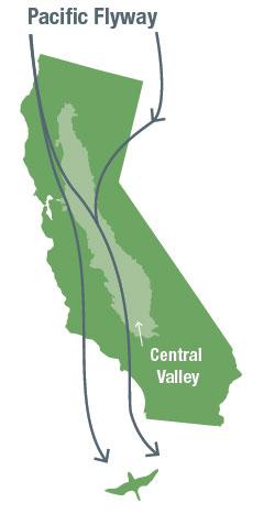
During their annual migration, more than 300 species of birds are estimated to use the Pacific Flyway as their connection between the Arctic and South America. Along this plumed pipeline lays the Central Valley of California, a flat valley stretching more than 650 kilometers through the middle of the state, and its wetlands are ideal for waterbirds to rest, feed, and winter. In fact, it’s believed that the Central Valley hosts up to 60 percent of the total Flyway population in some years.
In the last 150 years, things like flood control efforts, agricultural irrigation, and a booming Golden State population have left migrating waterbirds with much less stopover space than before. What’s more, the high real estate values of the region mean that conservation projects such as property easements and land purchases are prohibitively expensive since these birds stay only brief periods of time during the year.
Trying to tackle this hurdle, The Nature Conservancy (TNC) of California stepped in. Mark Reynolds, the lead scientist for TNC's California Migratory Bird Program, knew it would be a challenge. “How do you help things that move around and create habitat in places that may only be important for a few weeks or a few months out of the year?"
Before TNC could find a solution, it needed some data.
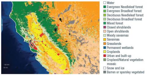
Enter eBird—a mobile application the Cornell Lab of Ornithology developed that asks avid birders to record bird sightings on a smartphone app and send the information to its database. Since its inception, eBird has logged 200 million bird observations—the largest biodiversity dataset in existence. Through a grant from our Program, the lab developed a computer-modeling system using eBird data combined with data from the Landsat, Aqua, and Terra satellites. These data and tools can predict the locations in the Central Valley that would be the most popular watering holes during the annual spring and fall migrations.

TNC also wanted to discern where it had gaps in the data for where the much-needed, temporary wetlands could be located. For this it turned to TNC partner Matthew Reiter, an ecologist for the conservation group Point Blue, who had been using Landsat observations to determine where the potential wetlands were in the Central Valley.
“The real value of the satellite… archive is that we’re able to look at the water distribution at a very fine spatial scale… which is really relevant in terms of understanding habitat for migratory waterbirds,” said Reiter.
Matching the geography and timing of surface water with the route and seasonality of migrating waterbirds from eBird, the research found key locations where extra surface water would provide perfect havens for the birds. In an effort to secure these “pop-up habitats,” TNC developed its BirdReturns program which relies on rice farmers to flood their fields for a two-week period during prime migratory season through a reverse auction.

How does a reverse auction work? First, rice farmers submit their bids for how much they would like to be paid for allowing their fields to temporarily remain idle by shallowly flooding them. Then TNC collects the most reasonable bids and selects the fields with the most desirable bird habitat, based on the eBird and Point Blue analysis. TNC then pays farmers to keep their fields flooded during critical migration times in the spring and fall.
For the rice farmers, the financial reward is their compensation for the potential liability they face by delaying field preparations for next season’s planting. “By holding our water, we’re taking a risk,” said Doug Thomas, a participating farmer in the Sacramento Valley. “Everything that goes along with that has to be factored into your economic equation.”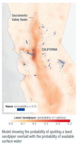
This novel method of renting temporary wetlands allows TNC to provide Flyway habitat for less than one percent of the cost of purchasing conservation easements. What’s more, the farmland is idle only during bird migration, and can produce rice at any other time of the year.
During its initial season, the BirdReturns program was an immediate success—approximately 10,000 acres of additional wetlands were acquired. For control purposes, the project group surveyed those participating fields and compared them to fields where water wasn’t applied. It found that more than 180,000 waterbirds comprising more than 50 different species used the temporary wetlands—30 times more than were counted on the dry fields.
Follow-up auctions continued to see rice farmers renting thousands more acres, with a cumulative total of about 30,000 acres of temporary wetlands gained by the end of 2015.
“It’s been a pretty astonishing success,” said Mark Reynolds.
“Farmers participated, and we were able to put habitat out there at a fraction of the cost to purchase that land or put an easement on it.”
Steve Kelling leads this project.


