Earth observations are helping countries manage their water security
A Vast and Vital Resource
The largest contiguous irrigation system on Earth, the Indus Basin provides water to 100 million people across South Asia. This basin is estimated to irrigate 45 million acres of farm land, and it’s considered the bread basket of Pakistan—essential for sustaining the agriculture and economy of the nation.
Until recently, monitoring the amount and location of available irrigation water could be a large undertaking of both labor and equipment. “Data were being collected manually, on a bi-annual basis... the collection, organization, and analysis of the data were time consuming and a tedious job,” noted Ashraf Muhammad, chairman of the Pakistan Council of Research in Water Resources (PCRWR).
A Passion and Purpose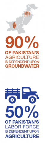
Enter Earth-observing satellites. Now, that enormous task is being expedited and enhanced with help from space, thanks to PCRWR, other South Asian government agencies, and an Applied Sciences project.
Faisal Hossain, associate professor at the University of Washington, led this project with both passion and purpose. “I’m originally from Bangladesh, so my heart is in the South Asian region,” said Hossain. “It was pretty clear to me that a lot of [the information] NASA satellites provide, somehow people didn’t really know about... It didn’t make sense not to use these observational capabilities.”
These space-based views included information from the Gravity Recovery and Climate Experiment (GRACE) mission to help monitor groundwater storage, as well as rainfall data from the Global Precipitation Measurement satellite. The project also developed and implemented a land-surface water model to give Pakistan the opportunity to look at its future water supply.
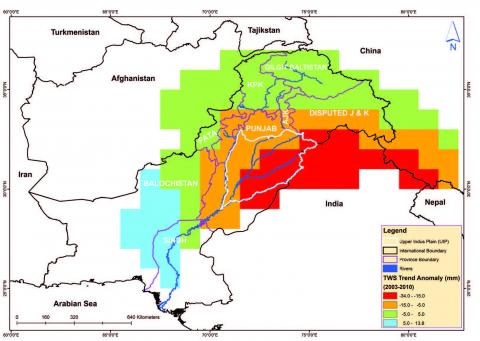
“GRACE-based data is readily available, free, can be applied at a large scale such as the Indus basin, and is reliable. Moreover, there are no data sharing issues as compared to traditional datasets.” Ashraf Muhammad, PCRWR
And in a novel approach, the project team used a fasttrack way of making the nation self-sufficient with this new data.
GRACE and Diplomacy
After meeting a bright and motivated PCRWR hydrologist named Naveed Iqbal at a GRACE training workshop, the project team wanted to try a new way of teaching Earth observation applications—which they dubbed their “backward-forward hybrid training model.” In this model, Hossain invited Iqbal to the University of Washington to attend a long-term satellite “boot camp.”
Iqbal jumped at the chance. “This training was an excellent opportunity to learn about the different applications of Earth observation technology for water resource management,” he said. “It was a great experience to work with experts.”
Hossain added, “He spent six months learning in a very intense laboratory residency framework on how GRACE works and how to process satellite data. We are finding this training model to be not only more effective, but also cost-effective.”
And when Iqbal had completed the course, he brought both his newfound knowledge and its uses back to his homeland and PCRWR.
The Flow of Information
Since Iqbal’s training, Pakistan has taken charge of its own water management—performing duties such as monitoring ground water storage, regulating ground water pumping, and augmenting surface water supplies.
With groundwater now monitored on a monthly basis, Muhammad emphasized the benefits of this new technology. “GRACE has empowered us to analyze the spatial and temporal variations of the groundwater system at the basin scale. Now, PCRWR is in a good position to play its advisory role.”
Iqbal agreed, and explained, “Using these satellites, we can indicate the areas that are most threatened by groundwater depletion. We can tell the farmers and help decision-makers formulate better and more sustainable policies.”
The project team hopes to help other countries in the region become self-sufficient as the project continues and expands. “Ideally, we would love to see all the South Asian water management agencies be able to control their water management destiny,” Hossain remarked, “And that can happen through these wonderful Earth-observing satellites and data which are made freely available.”
Faisal Hossain leads this project.


