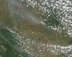
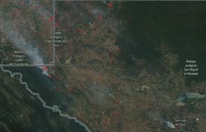
Fires started to burn in early March in the protected regions of Sierra del Lacandón National Park (also Laguna del Tigre), which is located in the tropical rain forest in the north west of Guatemala. By mid-march, foliage became visibly dry and unhealthy throughout the parks, and the fires continued to increase in size and intensity. Precipitation was well below normal, reaching approximately 110 mm less than the 2003-2016 average. Temperatures soared to 40oC (104oF) in some regions, setting the sustained conditions necessary for extreme fire.
These parks are part of the Maya Biosphere Reserve and are unique for their biodiversity, and they are also important as the Mesoamerican Biological Corridor that connects the protected areas of northern Guatemala with those of southern Mexico, like the Montes Azules Biosphere Reserve in Chiapas. Additionally, several ancient Maya archaeological sites are located within these park boundaries.
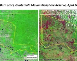
Due to the importance of the park, Guatemalan National Protected Areas Council (CONAP) with the assistance of the Wildlife Conservation Society and others several reached out to NASA to gain a remote view of fire from the sky. Moderate Resolution Imaging Spectroradiometer (MODIS) and Visible Infrared Imaging Radiometer Suite (VIIRS) data are being used to locate fire lines that are difficult to see from the ground, and these data are also being used to analyze long term fire trends. One Guatemalan weekly report highlighted the improved value of VIIRS data to locate small fires and the valuable long–term prospective offered by MODIS.
These fires are ongoing and our actions are ongoing. The Guatemalan agencies tasks to protect these forest would like to take the next steps to ensure improved fire and forest management. In that vein, the NASA Earth Science Disasters program established a response team to provide products and analysis, including novel fire severity and probability products led by the Jet Propulsion Laboratory (JPL) using Synthetic Aperture Radar (SAR) data from the European Space Agency’s (ESA) Sentinel-1A and 1B spacecrafts. Additionally, Landsat Enhanced Thematic Mapper (ETM) and Operational Land Imager (OLI) are being processed by research scientists at the University of Alabama in Huntsville (UAH)/Marshall Space Flight Center (MSFC). ASTER (Advanced Spaceborne Thermal Emission and Reflection Radiometer) flying on the Terra satellite is being task to collect high resolution images of these fires and fire scars.
Related Impact