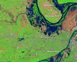
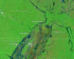
Between April 29 and May 1, 2017, a vigorous weather system delivered intense rain, heavy snow, and tornadoes across the central and southern United States. In many areas, rainfall totals surpassed 9 inches (23 centimeters), a deluge that led to dangerous flash floods and rivers cresting at record and near-record heights.
According to stream gauge data published by the National Weather Service, the Black River at Pocahontas, Arkansas, rose to nearly 29 feet (9 meters) on Tuesday, a record. The failure of a levee on May 3 forced the town to be evacuated. At Valley Park, Missouri, the Meramec River crested at just over 43 feet (13 meters) on May 2, which is just shy of a record. Forecasters say the Mississippi River at Cape Girardeau, Missouri, is on track to crest at just over 48 feet (15 meters) on May 6, which would also be a near-record.
Since clouds can block MODIS images and make flood assessment a challenge, NASA’s Disasters Program is working in collaboration with the European Space Agency (ESA) to provide flood mapping products to the U.S. Federal Emergency Management Agency (FEMA). NASA processes observations made by synthetic aperture radar (SAR) on ESA’s Copernicus Sentinel 1A and 1B satellites. SAR is of great value for flooding monitoring because it can “see” through clouds. In 2020, NASA plans to launch a SAR-carrying satellite called NISAR in collaboration with India's space agency.
Related Impact