Creating a Global Landslide Hazard Model with Dalia Kirschbaum
Dalia Kirschbaum is the Chief of the Hydrological Sciences Laboratory at NASA’s Goddard Space Flight Center (GSFC) and a research scientist, where she focuses on regional and global landslide hazard modeling. She is the principal investigator (PI) for a project funded by the NASA Earth Applied Science Disasters program area that uses satellite data to study where and when landslides may be happening around the world. The data helps Kirschbaum and other researchers understand the dynamic patterns of landslide activity, which have largely been underrepresented in hazards research. The insights gathered can be used to inform stakeholders worldwide, from local user communities to international organizations aiming to gain a better understanding of the patterning behind landslide occurrences.
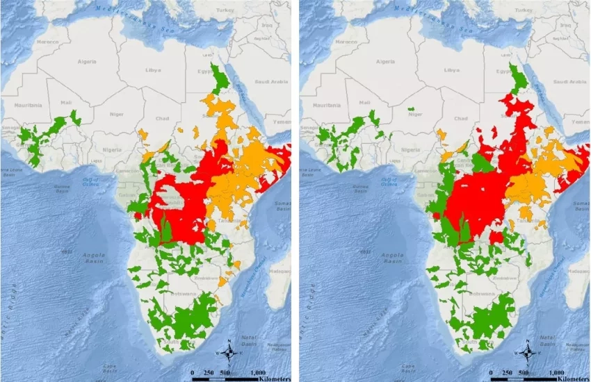
Kirschbaum and her team’s work is pioneering in landslide research, as it provides the only open-source, continually updating model of rainfall-triggered landslide hazards that is available in near real-time across most of the world. Within the model is a component of forecasting (estimating potential hazard over the next few days), as well as a real-time component via satellite data and post-event information that describes where landslides have taken place. The project is also developing new modeling capabilities to map where landslides have happened to better help researchers understand the dynamics and characteristics of landslides. The modeling framework also allows for the assessment of exposed assets, infrastructure and communities. This near-global perspective provides a new holistic picture of landslides that decision-makers can use to help local- and regional-scale response efforts and applications.
Compared to other hazards, such as floods and earthquakes, landslides are small, making them more challenging to observe. This difficulty in observing is why, in the past, there has been no global network for determining when they might occur. Although smaller in relative size, landslides are a pervasive hazard–killing thousands of people each year–yet researchers remain unaware of many events because reporting systems in many locations are non-existent.
The Global Precipitation Measurement (GPM) mission plays an essential role in Kirschbaum’s research, as it provides global estimates of rain and snow every 30 minutes. GPM data is ingested into the Landslide Hazard Assessment for Situational Awareness (LHASA) model and coupled with information on where given surface conditions indicate possible landslides. This regular ingestion of precipitation data allows for a better understanding of rainfall that could trigger landslides.
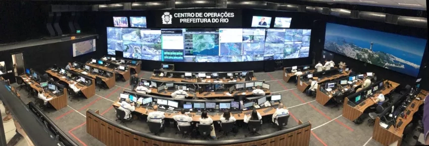
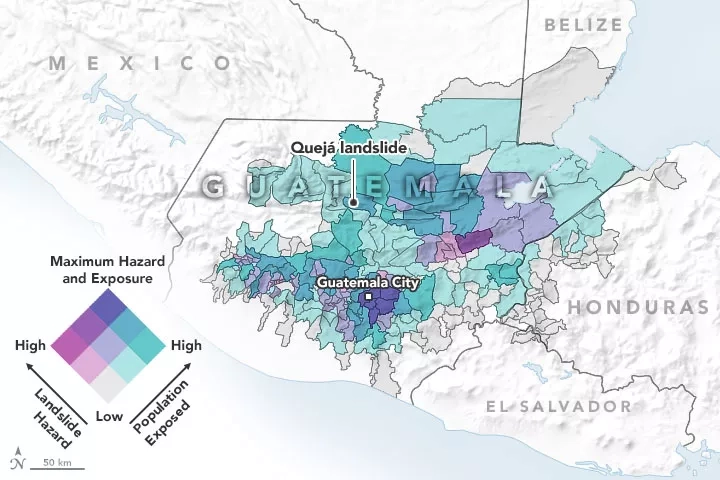
The first version of this model is open source (Version 1.1), and has served as a valuable framework for building customized models, such as the one that is running operationally within the city of Rio de Janeiro (LHASA-Rio). Kirschbaum explains, “The goal is not to have one solution or landslide model but to provide a framework that can leverage different types of data to provide awareness of potential landslide hazards at different scales. In this way, it can be more informative to stakeholders and decision-makers at a local scale but also to planners and scientists to understand landslides at a global scale.”
Improving Flood Monitoring and Alerting with Maggi Glasscoe
Another researcher aiming to improve disaster risk reduction and response is Margaret “Maggi” Glasscoe, a geophysicist at NASA’s Jet Propulsion Laboratory (JPL). Maggi is the principal investigator for a project that assesses floods on a global scale and creates risk alerts as part of the NASA Earth Applied Science Disasters program area. Widely published forecasting models are used to determine flood risk severity alerts, which are then validated by Earth observations (EO). The EO data is also used to determine the spatial and depth extents of floods and to help assess damage. Glasscoe explains that the main goal of her project is to devise a unified global risk assessment and alerting system that will feed into the Pacific Disaster Center’s (PDC’s) DisasterAWARE platform. DisasterAWARE is a software that serves a global platform of end-users who use it to make informed disaster response decisions. Like Kirschbaum’s work, Glasscoe’s is also pioneering in that it takes place on a global level. It will allow end-users to gauge how severe the alerts really are, and advance the understanding of floods and flood risk.
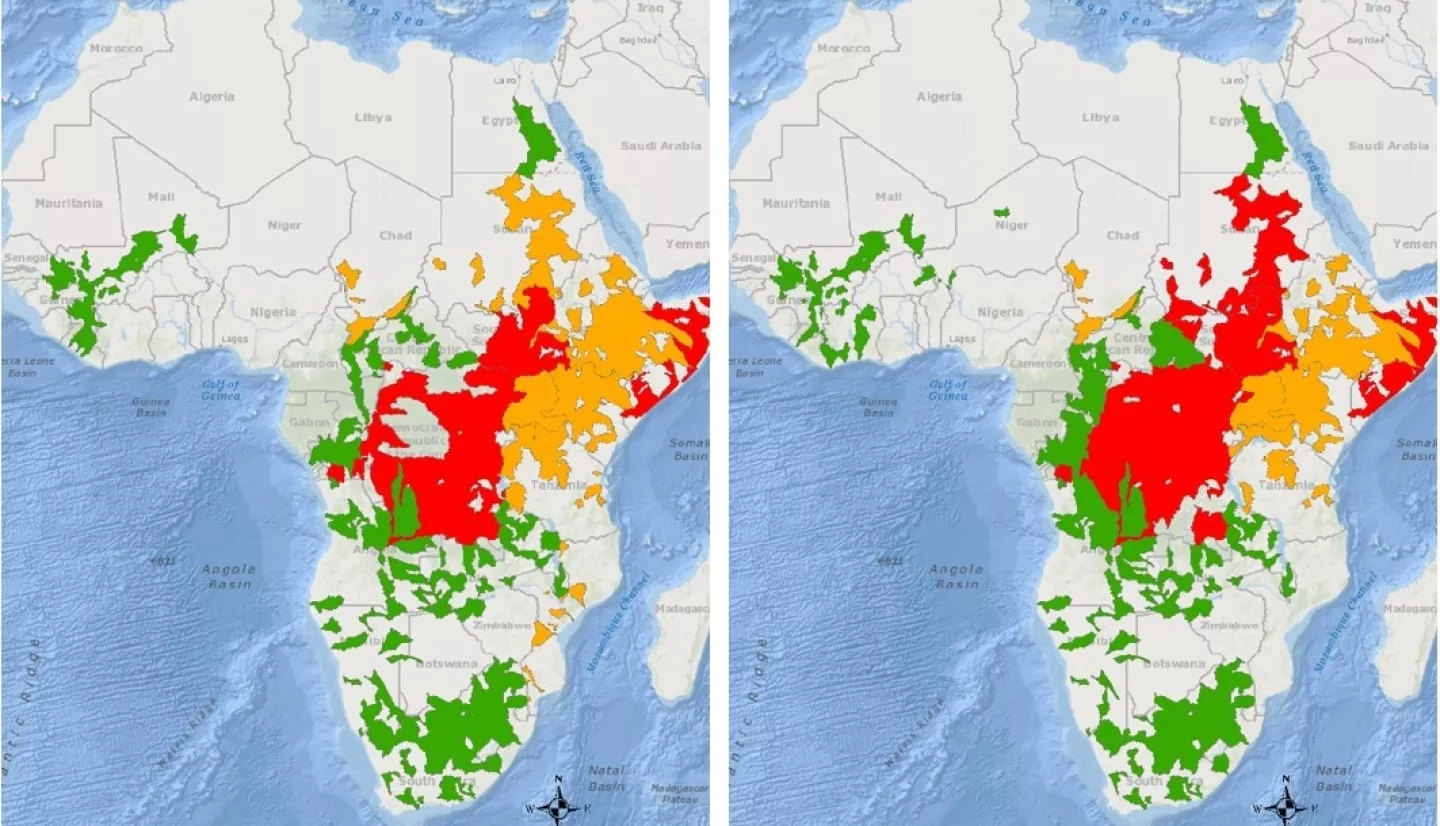
There are four main components to Glasscoe’s project. First, the project relies on a Model of Models (MoM) approach, which combines data on the geometry of a region with river and coastal flood risk, and integrates these into a risk index that describes the potential risk for flooding in a region and its watershed (a watershed is an area of land that drains or “sheds” water into a specific body of water). The model then creates flood alerts based on weighting these factors to determine risk-severity. Glasscoe’s research also aims to assess the spatial extent and depth of floods using EO data from synthetic aperture radar (SAR) satellite imaging and digital elevation models (DEMs). Researchers use that satellite data of the actual event to validate the MoM. There is also a damage-assessment track to the project, which utilizes more EO data to assess before and after images of the region, comparing them to identify potential damage. The fourth and final component of the project is integrating the previous steps and data into various scripts and processing, which is then prepared and fed into the PDC’s DisasterAWARE platform. The project recently used this multi-track MoM-based process to respond to flooding in Eastern and Central Africa. The project was able to create flood severity alerts for the local regions with assistance from two flood forecasting models: the Global Flood Monitoring System (GFMS) and the Global Flood Awareness System (GloFAS). Earth observation data was also utilized to examine inundation extent and some exposure information. These factors were used to identify areas that overlapped with flood alerts and were consequently at risk.
Collaboration Between Glasscoe and Kirschbaum
Glasscoe and Kirschbaum were quick to open up a dialog when they realized they had a stakeholder in common: the PDC. They began to collaborate, harnessing their compatible data and projects to further improve landslide and flood alerting. Through the model they both contribute to, Kirschbaum points out that many local regions and cities can use the global framework to create and customize their own models of alerting and preparing. Glasscoe emphasizes that there is “so much that can be gained from that cross-discussion.” Part of this discussion involves addressing how they can better align their activities related to the characterization of impact, identifying impacts from a specific trigger that causes a landslide or flood, and potentially other damage.
Through both of their projects, they utilize different satellite information, offering a uniquely holistic perspective of hazard impacts that can track triggering and damage patterns that would otherwise be difficult to identify. This is especially true for urban areas. Glasscoe connects their work to the big-picture goal: “What’s exciting for us is to be able to start to develop a system that allows for a global picture of creating an alerting system that allows for a better sense of the severity of these floods across the globe.” The two researchers share their motivations for improving data accessibility for stakeholders and decision-makers in disaster events—a key element for the Disasters Program. Glasscoe describes the purpose of their collaboration: “We saw an opportunity there that we might be able to leverage the technology that was being used by PDC in their DisasterAWARE platform, but [also to] use potential events that exist ‘out there’ to see if we might be able to show how cascading hazards interact.”
Motivation and Impact
With the variation of their expertise and data, Kirschbaum and Glasscoe focus on improving the alerts, as well as combining validation efforts in potential areas of risk, identification of exposure, and more. Glasscoe and Kirschbaum are keen to understand interactions between floods and landslides, such as how a flood can trigger a landslide. Kirschbaum summarizes her motivation for her project and collaboration with Glasscoe: “At NASA we have an opportunity to take data from satellites that cover the Earth and use it in new and innovative, creative ways to better understand hazards. We have the capability and flexibility to do that, to really push the envelope of what we can learn and how we can convey that to others.” Kirschbaum also mentions that she is motivated by the fact that NASA’s data and models are open source. As the data products are shared, these open-source resources improve continually through iteration with users and scientists. Anyone can easily become involved in the landslide team’s efforts and contribute to open source hazard data by using the Landslide Reporter at landslides.nasa.gov. This citizen science effort allows users to contribute valuable landslide hazard data by reporting local landslide events. The data gathered has been growing in size, but additional data is key to the global modeling of landslides that scientists and other end-users can use to better understand and respond to such hazards.
With the leadership and collaborative efforts of Kirschbaum and Glasscoe, the Disasters program area can further aid decision-makers, stakeholders, and other researchers worldwide in disaster response and recovery by supporting risk and reduction efforts. Glasscoe shares a fundamental motivation with NASA’s Disasters program area: “It’s a difficult job to be a decision maker and there’s a lot of information out there, but I’m hoping that the work we do is something that adds value to what decision makers are trying to do. …I’m hoping that the work will help provide some value to the end-user, and that’s what really motivates me—it’s trying to make a difference for people out there [who are] trying to deal with disasters.”


