Displaying 71 - 74 of 74
![Processed bands displaying NDVI from 30m Landsat 8 OLI data. The average 2022-2023 growing-season NDVI displayed is representing a heavy agriculture region within the Aconcagua River Basin in Central Chile. Blue to green colors represent areas of bare ground or water while yellow to dark red colors display densely vegetated regions. NDVI when compared to hydrology parameters can indicate heavily irrigated farmlands.](/sites/default/files/styles/lis/public/2024-01/2023Sum_PUP_AconcaguaAg_Websiteimage.jpg.webp?itok=LEUwJuA_)
Topic
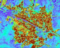
Aconcagua Basin Agriculture (Summer 2023) Team: Javiera Canales (Project Lead), Daniela Quintero, Carmen Petras Summary: The Aconcagua basin has experienced a prolonged drought since 2010...
![The data come from Landsat 9 OLI and MODIS satellites. The data shows surface reflectance imagery and combined (Terra and Aqua) MODIS burned areas from wildland fires in February 2023. The image shows parts of South-Central Chile covering Región del Maule, Región del Bío-Bío, and Región de La Araucanía. The processed data show burned areas in the region of interest from wildland fires and the smog from the fires. Red patches indicate burned areas.](/sites/default/files/styles/lis/public/2024-01/2023Sum_PUP_ChileWildlandFires_WebsiteImage.jpg.webp?itok=M4LTKzkk)
Topic
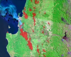
Chile Wildland Fires (Summer 2023) Team: Benjamin D. Goffin (Project Lead), Quinton Deppert, Aashutosh Aryal Summary: Since 2010, Central and South-Central Chile have recorded abnormally...