Displaying 31 - 40 of 94
![](/sites/default/files/styles/lis/public/images/develop-legacy/2018/spring/images/LRC-2018-E3-G_2018Spring_JPL_BlackRockPlayaUrban_WebsiteImage_00000.png.webp?itok=XtuKvgbA)
Topic
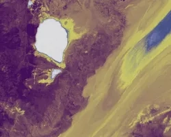
Since the early 2000s, wind-deposited sediment mounds have been growing and encroaching onto the Black Rock Playa of the Black Rock Desert-High Rock Canyon Emigrant...
![](/sites/default/files/styles/lis/public/images/develop-legacy/2018/summer/images/2018Sum_ID_IdahoWater.jpg.webp?itok=0w-cdqNo)
Topic
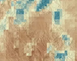
Soil moisture is a critical component of ecosystem health, particularly in semi-arid landscapes where seasonal and infrequent precipitation is one of the primary controls on...
![](/sites/default/files/styles/lis/public/images/develop-legacy/2020/spring/images/2020Spring_JPL_GreatLakesWaterII_WebsiteImage.jpg.webp?itok=KG17RNew)
Topic
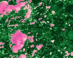
The Great Lakes Basin is one of the world’s largest freshwater ecosystems. The Basin harbors over 200,000 acres of wetlands that provide a variety of...
![](/sites/default/files/styles/lis/public/images/develop-legacy/2019/spring/images/2019Spring_JPL_GreatLakesWater_WebsiteImage.jpg.webp?itok=BHzl6sJi)
Topic
Wetlands are a critical feature of our landscape for the ecological services they provide, including protecting water quality, providing habitat to rare species, mitigating erosion...
![Landsat 8 OLI derived MNDWI imagery mosaicked from October 17, 2020, to December 2, 2020. Located near the Río Patuca (Patuca River) in Ahuas, Honduras, permanent water and flood is represented as bright red and orange while blue depicts other land cover types and clouds. Examining floods from disasters like Hurricanes Eta and Iota helps decision makers improve mitigation and response efforts.](/sites/default/files/styles/lis/public/2022-03/2021Fall_MSFC_CentralAmericaDisasters_WebsiteImage.png.webp?itok=pweSILBO)
Central America Disasters (Fall 2021) Team: Caroline Williams (Project Lead), Lauren Carey, Maria De Los Santos, Deanna Fanelli, and Payton Ireland Summary: In November 2020...
![Magnitude of largest model break in Continuous Change Detection Algorithm harmonic regression model, indicative of clearcut logging in the Oregon coast range forests. Imagery from Landsat 4-5 TM, Landsat 7 ETM+, and Landsat 8-9 OLI from across the study period 2000-2021 over standard hill shade. Patches of blue show clear cut areas with lavender then yellow indicating higher magnitude. Green areas represent forests untouched during the study period.](/sites/default/files/styles/lis/public/2024-01/2023Sum_MA_OregonCoastRangeEco_websiteImage.jpg.webp?itok=sGJs5DSB)
Oregon Coast Range Ecological Conservation (Summer 2023) Team: Emily French (Project Lead), Uma Edulbehram, Sarah Hughes, Madison Arndt Summary: Logging operations are widespread across the...
![Forest cover and land surface temperature (LST) around Maine's Penobscot River during Summer 2021. The shades of green distinguish between evergreen (dark) and deciduous (light) forest which were classified using Landsat 8 OLI imagery. The purple gradient corresponds to LST derived from Terra MODIS where the warmest areas, including Bangor, are white. Changing land use and warming temperatures along Maine’s rivers are associated with reducing juvenile Atlantic salmon (Salmo salar) survivorship.](/sites/default/files/styles/lis/public/2022-11/2022Sum_GSFC_MaineEcoIII_WebsiteImage.jpg.webp?itok=EiYDdUqO)
Maine Ecological Forecasting III (Summer 2022) Team: Jonathan Falciani (Project Lead), Colin Hogan, Linda Mitchell, Makario Sarsozo Summary: Shifting patterns in land use and land...
![Potential for land cover to change from trees to grass, forb, and herb between 1987 and 2020 in the Teton Mountain Range. Image created from LCMS land cover data which are derived from Landsat 4, 5, 7, and 8 imagery (1987 - 2020). High transition potential is depicted in yellow and low transition potential is indigo. Transition potentials help to forecast land cover and inform land managers on the locations of suitable bighorn sheep habitat.](/sites/default/files/styles/lis/public/2022-03/2021Fall_ID_GrandTetonEco_WebsiteImage.png.webp?itok=q05PkvLT)
Grand Teton Ecological Forecasting (Fall 2021) Team: Alex Posen (Project Lead), Allyson Earl, Sarah Hettema, and Michael Hitchner Summary: Grand Teton National Park provides habitat...
![2022 Spring CO Boulder County Disasters Website Image](/sites/default/files/styles/lis/public/2022-06/2022Spring_CO_BoulderCountyDisasters_WebsiteImage.png.webp?itok=1X2GgkIw)
Boulder County Disasters (Spring 2022) Team: Sarah Hettema (Project Lead), Jennifer Rogers, Ibuki Sugiura, Erin Twaddell Summary: In recent years, record-breaking wildfire activities in the...