North Carolina’s public health and safety agencies are working with the NASA Disasters program area to identify ways NASA Earth observations can help inform early disaster response when hurricanes and heavy rains strike. A Disasters team joined the state’s annual hurricane exercise to learn what NASA resources could be most useful during a hurricane or tropical storm event – when every second counts.
As climate change contributes to increasingly severe hurricanes, coastal U.S. states are working across different phases of the disaster cycle – including preparedness pre-event – to ready emergency response measures to protect local communities. The state of North Carolina already has extensive flood monitoring capabilities, and adding the power of NASA satellite data to these efforts can help them more quickly and accurately assess the location and extent of flooding. North Carolina Emergency Management invited members of the Disasters program to participate in a statewide hurricane exercise, where first responders and decision-makers work together across agencies to coordinate the best options to protect lives and livelihoods from the cascading hazards associated with a major hurricane.
“We don’t do their jobs for a living, so exercises like this are the best way for us to fully understand their work. We did a lot of listening, to understand what they need and even what they don’t,” said Lori Schultz, Disasters center coordinator at NASA’s Marshall Space Flight Center. “We learned they have tremendous modeling and remote sensing capabilities but could use NASA’s help to use satellite data to find flooding. So we built a flood mapping portal for them to use during the exercise to demonstrate what’s possible.”
“To prepare for the increase in frequency and intensity of weather-related events, we can assist North Carolina communities by obtaining and utilizing all available data and technology,” said Gary Thompson, deputy risk management chief for North Carolina Emergency Management. “Pre- and post-storm satellite imaging from NASA can help with long term planning and mitigation, and also with damage assessment right after an event. Obtaining additional data quickly can assist with securing a disaster declaration for aid in the impacted area.”
Hundreds of participants from the state and county agency level, local state organizations, NASA and Federal Emergency Management Agency (FEMA) participated in this exercise to simulate emergency response and evacuation before, during and after hurricane landfall.
“We’ve provided data to North Carolina in a few instances already, but it’s critical to have these conversations before a disaster strikes,” said Schultz. “When a hurricane hits, there’s no time to go back and forth on what kind of information might be useful for first responders – they have to hit the ground running.”
Ronan Lucey, a geographic information system (GIS) specialist and Disaster Coordinator at the University of Alabama in Huntsville and NASA Marshall, also participated in the exercise.
“We’ve been coordinating with colleagues in North Carolina on a variety of flood-related topics, starting with figuring out their familiarity with Earth observations,” Lucey said. “Developing these relationships is the most important part – we have to build trust, the people putting this data into use have to have confidence that the products we’re providing are accurate and designed for their needs.”
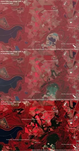
This exercise is not the first time the Disasters team has worked with North Carolina’s emergency response teams. In November 2020, North Carolina Emergency Management reached out to the Disasters program area to understand how NASA Earth observations could help determine floodwater extent in the face of sudden flooding. That year, Tropical Storm Eta brought heavy rainfall to areas of the state like Wayne County, causing extensive river flooding and road closures. The Disasters team generated several false-color maps of the region in the days leading up to the peak flood heights to help determine where buildings and roads may have been impacted by the most severe flooding.
Schultz says that the immense amount of data publicly available is exactly why coordination is needed – early and often. “The public safety agencies are the experts in emergency response, but they can’t be expected to be experts in all of our satellite data,” she noted.
NASA and the Japan Aerospace Exploration Agency’s (JAXA) Global Precipitation Measurement (GPM) satellite mission observes the structure of precipitation within tropical cyclones and hurricanes, and NASA’s Integrated Multi-Satellite Retrievals for GPM (IMERG) product maps their intense rainfall rates over time to provide situational awareness for potential flood events. Over the ocean, NASA’s Short-term Prediction Research and Transition Center (SPoRT) provides crucial data on the ocean environment surrounding a storm, which can provide insights into how strong a storm might get. And following landfall, optical data collected by NASA’s Terra and Aqua satellites can map the extent and severity of flooding. Should clouds obscure the view, NASA Airborne Science instruments can also be used to detect flooding.
“When we have a better understanding of their needs,” Shultz said, “we can make recommendations of what information is the most relevant to response efforts, and guide how that data is processed in a way that’s useful – for example, by turning it into easy-to-read maps.”
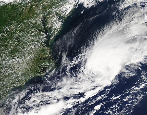
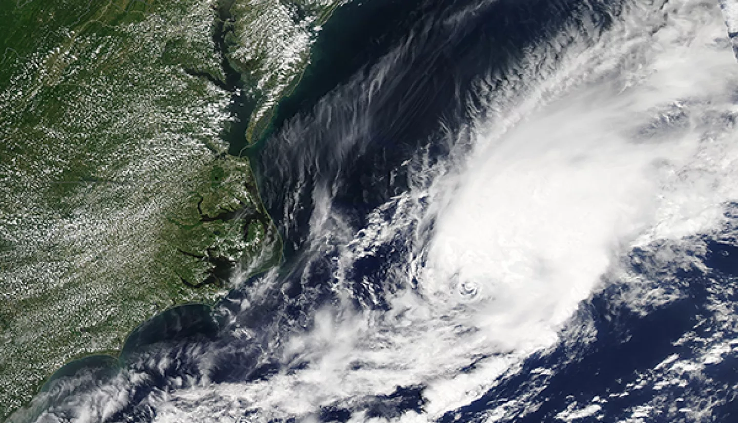
This pipeline of communication proved useful once again in July 2021, when Tropical Storm Elsa was churning toward the North Carolina coast. The Disasters program area worked with the North Carolina Emergency Management Agency to help identify pre- and post-event optical satellite imagery for flood monitoring and stood ready to assist other regional stakeholders and partners with Earth-observing data and analysis to aid response and recovery efforts, both in the U.S. and the Caribbean islands impacted by Elsa.
The Disasters program area plans to continue monthly coordination meetings with North Carolina stakeholders. These connections will not only provide rapid response data in the face of emergencies, but also demonstrate the benefits of using NASA data and science in their decision making, how to interpret data for their applications, and where they can access this information when time is of the essence. By carefully designing tools in response to their unique needs, the Disasters program area hopes to enhance their flood monitoring capabilities and inform decision-making to protect public safety.
This story is part of our Space for U.S. collection. To learn how communities are using NASA data in your state, please visit nasa.gov/spaceforus.