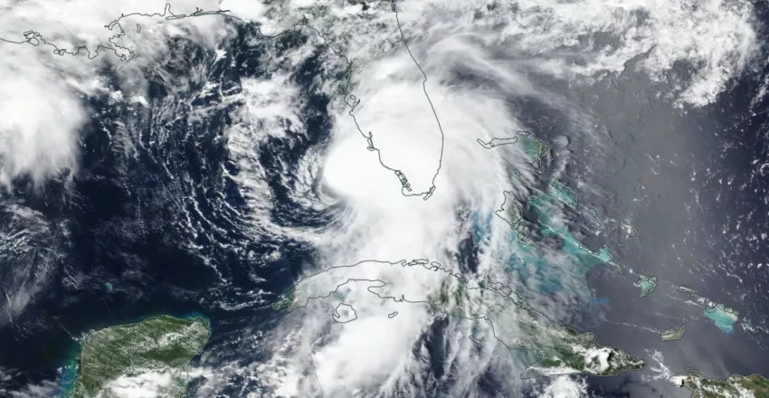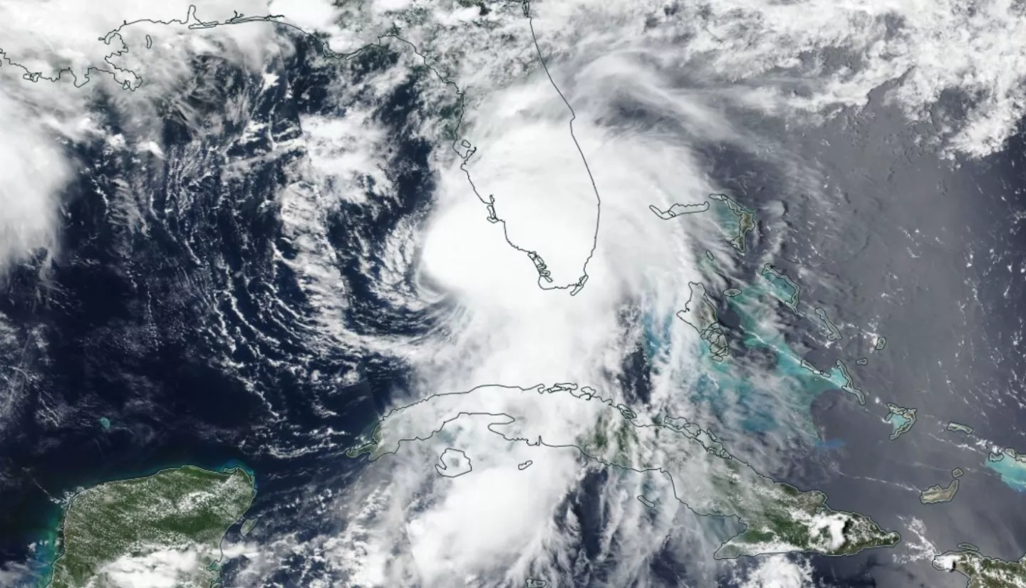
Tropical Storm Elsa is the third tropical storm system of the 2021 Atlantic hurricane season to make landfall in the continental United States, and the fifth named storm in what is expected to be another active hurricane season. Elsa made landfall near Steinhatchee, Florida, the morning of Wednesday, June 7, putting the region under a tropical storm warning and bringing heavy rainfall, intense gusts of wind, and storm surge to the Florida coast. Current forecasts indicate that Elsa will be heading northeast, rapidly traveling over land up the eastern United States, and many cities in its projected path are already under a tropical cyclone watch.
NASA Disasters Mapping Portal - Tropical Cyclone Dashboard
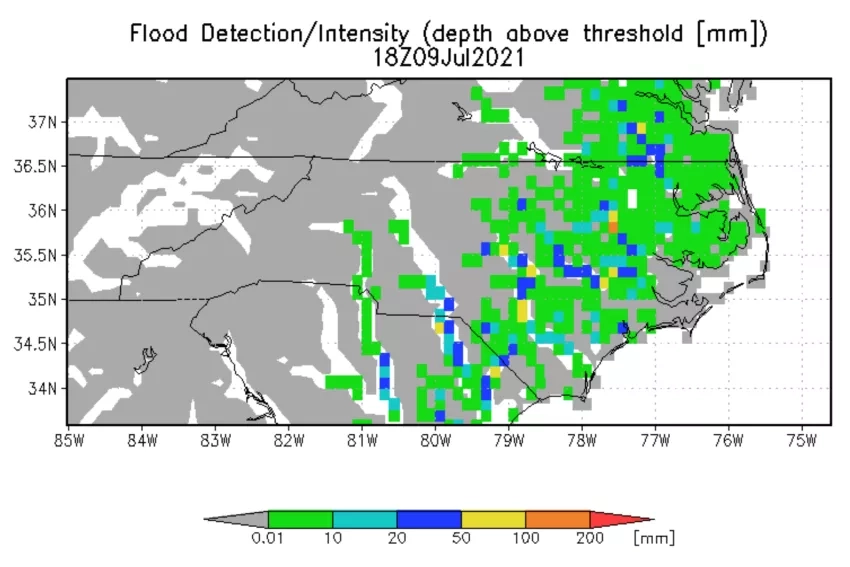
In its role to aid risk reduction, response, and recovery for hurricanes and other disasters, the NASA Earth Applied Sciences Disasters program area has activated efforts to monitor Tropical Storm Elsa. Researchers from the ROSES A.37 projects Integrating SAR Data for Improved Resilience and Response to Weather-Related Disasters and Advancing Access to Global Flood Modeling and Alerting using the PDC DisasterAWARE Platform are working to identify potential optical and Synthetic Aperture Radar (SAR) satellite overpasses that could be used to map the extent of floodwaters. NASA-affiliated researchers working with the UMD Global Flood Monitoring System (GFMS) are also generating flood forecast and flood detection maps using NASA IMERG data. The Disasters program area is working with the North Carolina Emergency Management Agency (EMA) to help identify pre- and post-event optical satellite imagery for flood monitoring, and stands ready to assist other regional stakeholders and partners with Earth-observing data and analysis to aid response and recovery efforts, both in the U.S. and the Caribbean islands impacted by Elsa.
Before, During, and After Disasters Strike
While NASA is best-known for its work involving rocket ships and outer space, the correlation between space-study and natural hazards on Earth is less commonly understood. From space, we can view the Earth as a system of interactions among complex and interconnected processes – processes such as atmospheric, hydrospheric, or geospheric cycles – and use this perspective to develop a greater understanding of how hazards form and what we can do to prevent hazards from becoming disasters. NASA’s Earth-observing satellites collect data on storms that scientists can then use to create near real-time products to support disaster response.
For example, NASA / JAXA’s GPM satellite frequently observes the structure of precipitation within tropical cyclones and hurricanes, and the Integrated Multi-Satellite Retrievals for GPM (IMERG) product maps their intense rainfall rates over time to provide situational awareness for potential flood events. Over the ocean, NASA’s Short-term Prediction Research and Transition Center (SPoRT) and NOAA’s NowCOAST composite Sea Surface Temperature (SST) inform people on the ocean environment surrounding a storm, which can provide insights into whether a storm will intensify. Following landfall, optical data collected by the Aqua, Terra, Landsat, or Suomi NPP satellites can map the extent and severity of flooding – and should clouds obscure the region, SAR data from ESA Sentinel satellites or NASA Airborne Science instruments can also be used to detect flooding. In addition to providing insights into how storms form and intensify, NASA satellites also provide key inputs to weather models to help generate life-saving forecasts.
Before, during, and after hurricanes strike, NASA provides valuable resources to monitor storms and mitigate their impacts to society.
Learn More about How NASA Monitors Hurricanes and Aids Response Efforts
- NASA and Hurricanes: Five Fast Facts
- NASA Helps the World Weather the 2020 Hurricane Season
- NASA Scientists Available for Interviews on Hurricanes, Tropical Storms
NASA Hurricanes Datasets and Tools
- NASA Disasters Program Hurricanes & Tropical Cyclones Support One-pager
- NASA Earthdata Products for Severe Storms
- View Hurricane Elsa satellite data in NASA Worldview