An ongoing collaboration between NASA and the Volcanic Ash Advisory Centers leads to safer and more efficient flight redirects around volcanic plumes.
The last golden rays of the evening sun kiss the tarmac as flight crews ready their planes for transcontinental journeys. Inside air traffic control centers worldwide, experts study their screens to ensure the path ahead is clear for each flight. In the airplanes, flight crews brief passengers on safety procedures with calm collected voices. But sometimes, somewhere along their planned flight path, that calm is being shattered by a different kind of voice: the explosive boom of an erupting volcano. Even if that menacing voice of nature is hundreds of miles away, and therefore silent to the pilots about to embark, it demands attention.
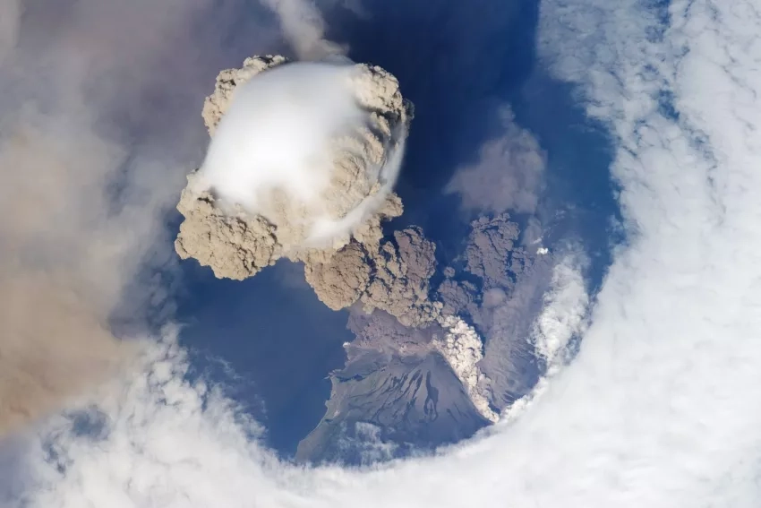
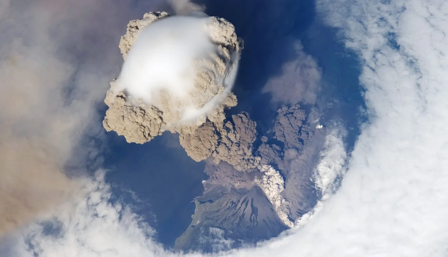
Such explosive eruptions release hazardous gasses and volcanic ash – a concoction of minuscule rock and volcanic glass fragments. When this ash rises high into the atmosphere, it can pelt aircraft like a giant sandblaster, obstructing visibility, eroding paint, or worse – causing engine failure.
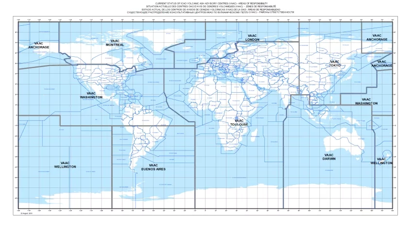
To counter this aerial threat, the World Meteorological Organization and the U.N’s International Civil Aviation Organization established nine Volcanic Ash Advisory Centers (VAACs) globally in the 1990s. These centers use computer models, satellite data, and ground and pilot reports to predict the movement and spread of volcanic ash, issuing vital advisories that aid global authorities in making educated decisions on flight re-routing and airspace closures.
Closing airspace when volcanic ash is detected is rare, but such closures have a ripple effect on thousands of passengers and multimillion-dollar cargoes. It’s another reason that being able to notify authorities where dangerous ash is – and where it isn’t – is indispensable.
To enhance the Volcanic Ash Advisory Centers’ capabilities, NASA provides real-time access to volcanic ash and sulfur dioxide (SO2) data using direct broadcast from polar-orbiting weather satellites. Suites of sensitive instruments, such as VIIRS and OMPS, offer a comprehensive overview of volcanic plumes from high above our planet’s atmosphere. These orbiting sensors gather information that helps track the movement and densities of volcanic ash and sulfur dioxide gas emitted from these eruptions.
But NASA's contributions don’t end at imaging. Decades of research to better understand our planet’s atmospheric composition deepens our understanding of volcanic ash and how the large amounts of SO2 gas that volcanoes loft high into our atmosphere behaves. It also helps equip analysts at the VAACs with the most advanced science products to enhance their predictive models. To optimize the application of NASA resources, NASA’s Disasters program arranges biannual virtual workshops, enabling direct interaction between VAAC teams and NASA experts for continuous knowledge exchange.
This summer marked the third such collaborative session. VAAC representatives were introduced to NASA's cutting-edge technology, including innovations from Dr. Nickolay Krotkov's team at NASA’s Goddard Space Flight Center and Dr. Vincent Realmuto’s team at NASA's Jet Propulsion Laboratory. Their joint research with partners like the U.S. Geological Survey’s Alaska Volcano Observatory and the Anchorage Volcanic Ash Advisory Center has been focused on improving direct-broadcast satellite products to monitor volcanic ash, SO2 clouds, and forest fire smoke plumes. The work led to a suite of direct-broadcast satellite products that allows analysts to monitor volcanic ash at night – a development that is especially useful in polar regions, such as Alaska, which endure long periods of darkness that make geostationary weather satellite observations challenging.
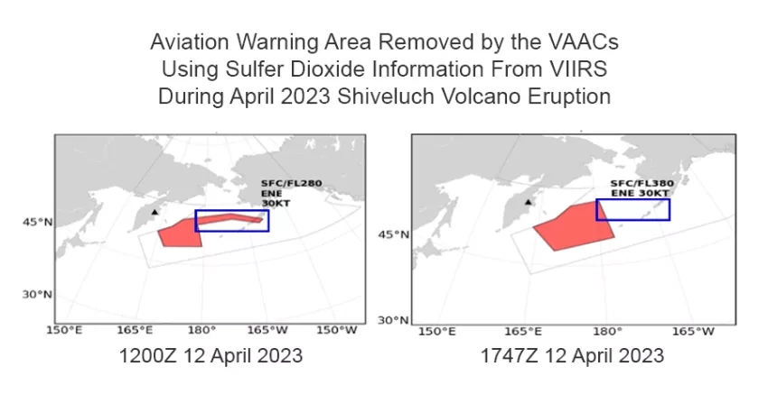
The April 2023 eruption of Shiveluch in Russia exemplified the advanced Earth science capabilities NASA offers to the VAACs. Shiveluch, one of the most active volcanoes in Russia’s Kamchatka Peninsula, projected ash over 12 miles up and 300 miles northwest, affecting numerous flights around Alaska. However, insights from NASA products allowed the Anchorage VAAC to rapidly modify ash forecasts and reopen airspace in an eastern section of the original warning, potentially saving time, money, and reducing unnecessary aircraft emissions.
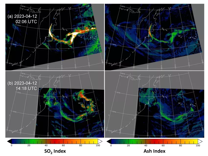
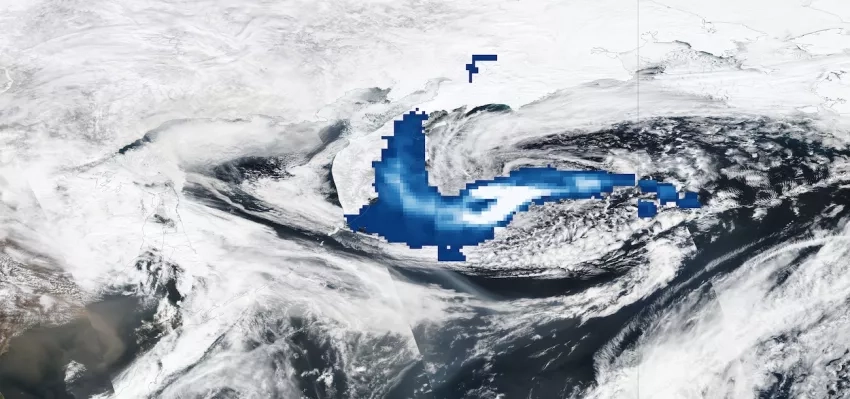
The multispectral thermal infrared measurements acquired by VIIRS are sensitive to volcanic SO2 and ash. Index maps of SO2 (upper left) and ash (upper right) depict the Shiveluch eruption plume at 02:06 UTC on April 12, 2023. Index maps of SO2 (bottom left) and ash (bottom right) derived from VIIRS night-time observations acquired at 14:18 UTC, highlight the dispersion of the eruption plumes in the 12 hours following initial observation. Credit: NASA
Krotkov was joined in the workshop by Nathan Eckstein from the Anchorage VAAC and Dov Bensimon from the Montreal VAAC to demonstrate to the wider group how collections of real-time satellite direct broadcast data allowed analysts to differentiate detections of SO2 emissions from volcanic ash during the Shiveluch eruption. While sulfur dioxide can be hazardous to breathe, it is unlikely to damage a modern aircraft compared to flying through a volcanic ash plume.
Differentiating SO2 gas from volcanic ash does more than satisfy scientific curiosity. Eckstein, a physical scientist at NOAA’s National Weather Service, noted how the VIIRS Ash and SO2 Index products afford near real-time insights, enhancing confidence in producing detailed forecasts. “The Anchorage VAAC was able to use these products to reduce a large area covered by a VAA (volcanic ash advisory) and VA SIGMET (volcanic ash severe weather advisory) over the Gulf of Alaska that was causing many disruptions to a much smaller impact area over the center of the gulf.”
The latest VAAC-NASA workshop saw contributions from other leading NASA scientists as well. Discussions included using the MISR sensor to predict volcanic ash cloud altitudes, as well as an overview of NASA’s recently launched TEMPO spectrometer presented by TEMPO’s deputy program applications lead, Aaron Naeger.
Together, the VAACs, NOAA, USGS, and NASA ensure that when our planet’s volcanoes speak, those charged with flight safety understand their message. And while volcanoes may occasionally rewrite flight routes, the continued collaboration between NASA scientists and experts at the Volcanic Ash Advisory Centers continues to light the way to safer and more efficient flights around the globe.