Displaying 131 - 140 of 305
![](/sites/default/files/styles/lis/public/iota-11-17-20.jpg.webp?itok=R71UctUC)
![Normalized Difference Moisture Index (NDMI) processed 2021 Landsat 8 OLI imagery over land and Sentinel-2 MSI over ocean, ranging from yellow (low) to blue (high), for Hilo, Hawaii. Overlayed with four-day rainfall accumulation cells in blue acquired during Hurricane Lane (Aug 22-25, 2018) from CHIRPS Daily. NDMI monitors water content of leaves and is useful for classifying land cover. Impervious surfaces and areas that have received excessive historical rainfall are susceptible to future flood events.](/sites/default/files/styles/lis/public/2022-03/2021Fall_AZ_HawaiiIslandDisasters_WebsiteImage_1440.png.webp?itok=UF3NMIoI)
Hawai‘i Island Disasters (Fall 2021) Team: Garren Kalter (Project Lead), Rose Eichelmann, Sanketa Kadam, Erin Azuma, and Anna Mikkelsen Summary: As the County of Hawai‘i...
![Normalized Difference Water Index (NDWI) to visualize drainage networks around the Unalakleet River in Alaska, calculated from an August 2021 Landsat 8 OLI image. Yellow represents standing or flowing water and potential flood zones, while the dark blue represents drier, upland regions. Unalakleet's climate resilience planning prioritizes relocation to upland regions while avoiding areas that have experienced significant permafrost degradation.](/sites/default/files/styles/lis/public/2023-10/2023Sum_GA_UnalakleetClimate_WebsiteImage.jpg.webp?itok=9m9RUwoB)
Unalakleet Climate (Summer 2023) Team: Ian Lee (Project Lead), Clara Maxwell, Daniel J. Marsden, M. Jaweed Nazary Summary: The coastal community of Unalakleet is currently...
![](/sites/default/files/styles/lis/public/images/develop-legacy/2020/fall/images/2020Fall_MA_CharlesRiverWatershedWater_WebsiteImage.jpg.webp?itok=DHzT_yqT)
Topic
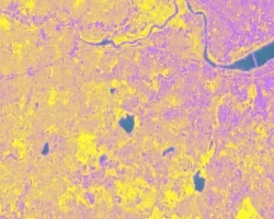
The Charles River watershed intersects 35 municipalities within the Boston Metropolitan Area and has a population of 1.2 million, making it one of the most...
![](/sites/default/files/styles/lis/public/images/develop-legacy/2020/fall/images/2020Fall_MSFC_Amazonia_Disasters_Website_Image.jpg.webp?itok=8SzNXrl9)
Topic
Artisanal and small-scale gold mining (ASGM) is responsible for a large fraction of deforestation and disturbance in Amazonia. These activities cause severe impacts on the...
![](/sites/default/files/styles/lis/public/images/develop-legacy/2021/summer/images/2021Sum_JPL_CoastalCaliforniaWaterII_WebsiteImage.jpg.webp?itok=vq31qia9)
Topic
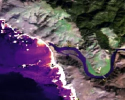
Estuaries are dynamic environments that provide a host of vital ecosystem services. California’s Marine Life Protection Act protects such ecosystems by creating Marine Protected Areas...
![Hurricane Isaias traveling northwest between Cuba and the Bahamas on Friday, July 31, 2020, as seen from the International Space Station. Credits: NASA/Astronaut Col. Doug Hurley](/sites/default/files/styles/lis/public/2020-08/isaias_astronaut.jpg.webp?itok=6vi0Xof4)