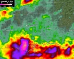
In August 2016 an extremely severe rainfall event hit Louisiana and southern Mississippi when a very slow moving, low pressure system continuously pulled tropical moisture from the Gulf of Mexico. Rainfall from the system exceeded 20 inches in some parishes which caused rivers and waterways, particularly the Amite and Comite rivers, to reach record levels.
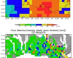
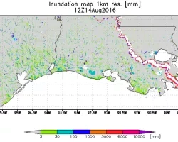
Coordination efforts expanded significantly throughout the incident and were truly a global effort. Support has been provided from international partners throughout the European Union, to include Germany, Italy, and Sweden; across the Federal Government to include but not limited to FEMA, USGS, NOAAand the State Department; Academia to include the University of Maryland, The University of Colorado, and the University of Texas; and state and local Emergency Management Agencies. NASA provided models, guidance and data products from Synthetic Aperture Radar (SAR), from the Global Flood Model (GFMS 1Km NOWCAST) as well as access to the once daily 12 km FORECAST and routine products from GPM and MODIS-flood.
Related Impact