Team:
• Jim Lee (Texas A&M University – Corpus Christi), co-I
• Yuxia Huang (Texas A&M University – Corpus Christi), co-I
• Lapone Techapinyawat (Texas A&M University – Corpus Christi), graduate student
• Wen Zhong (Texas A&M University – Corpus Christi), graduate student
• Ziba Abbasian (Texas A&M University – Corpus Christi), graduate student
• Hannah Garcia (Texas A&M University – Corpus Christi), undergraduate student
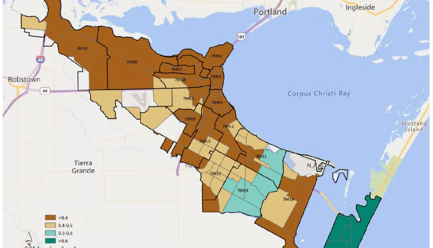
Executive Summary: Increasingly more communities in the United States have begun levying a separate utility fee to support local stormwater management services in the face of flooding woes under climate change. Most local stormwater fee programs rely on the determination of impervious area that causes the most surface runoff in urban areas. Instead of measuring impervious surfaces, the most popular method for residential properties is the application of a fixed runoff factor. Using Corpus Christi in Texas as the study area, this project aims to i) evaluate how well the official runoff factor represents the impervious area of individual land parcels and ii) explore the spatial patterns of the deviation of the runoff factor from the official benchmark across neighborhoods in the context of social equity.
This project begins with the estimation of impervious area for roughly 9,000 single-family residential land parcels in Corpus Christi. The impervious area measurements are the outcomes of applying a deep learning model to high-resolution HxGN aerial imagery coupled with satellite Earth observations. The estimates of impervious area on individual land parcels are compared to the 50% benchmark, which serves as a proxy for the runoff factor used to determine the City of Corpus Christi’s stormwater fee for single-family land properties. Deviations in the average runoff factor from the official benchmark are uneven across the city’s different neighborhoods defined by census tracts or ZIP codes. Statistical model regressions provide evidence that the gap between the official runoff factor and our measures is wider among census tracts with disproportionately more Hispanic residents and lower household income. At odds with the principle of social equity, this finding implies that residents in neighborhoods of lower socioeconomic status are overburdened by the new stormwater fee. This social dilemma is resolved through the way housing development unfolded historically. Neighborhoods with less surface runoff tend to be those occupied predominately by Hispanic and low-income households that are typically less able to afford more expensive homes in neighborhoods with more runoff.
The dataset in this project not only contributes to the design of a stormwater fee structure that better represents surface runoff, but it also helps city officials advance social equity for homeowners in historically underserved communities. More importantly, this project demonstrates the feasibility of applying a transdisciplinary methodology, which converges geospatial analysis with socioeconomic modeling, to a wide variety of environmental challenges that exacerbate social inequity within a community.
Related Impact