Displaying 151 - 160 of 313
Topic
Colombia contains a variety of endemic species, making it one of the most biodiverse regions in the world. Due to a recent peace treaty between...
Topic
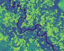
Cali Water Resources (2024 Spring) Team: Tallis Monteiro (Project Lead), Gabi Davidson-Gomez, Nathan Tesfayi, Raquel Trejo Summary: Recent research has documented the global decline of...
Topic
The gopher frog (Lithobates capito) is an endangered species facing extinction within the next century due to loss and alteration of its habitat. With limited...
Topic
Fisher’s Peak is a 77.5 km2 property southeast of Trinidad, Colorado that is planned to become Colorado’s newest state park. The area has experienced limited...
Topic
SPARROW is widely used throughout the United States for long term, steady state water quality analysis. However, users are increasingly asking for a dynamic version...
Topic
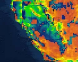
California’s Central Valley is one of the most productive agricultural areas in the world, producing approximately $20 billion in crops annually. The recent California droughts...