Displaying 31 - 40 of 53
Applied Sciences
Prizes & Challenges
![Present day Island of Hawai'i coastal flood risk, with higher risk indicated in dark blue, was modeled to aid the County of Hawai'i in their shoreline setback plan. Sea Surface Temperature Anomaly (SSTA) data from 2022 GHRSST MODIS indicate low temperatures in the East (red) to high in the West (orange). Inland, high probability locations of wetlands are shown in bright yellow and will aid in climate adaptation planning. ](/sites/default/files/styles/lis/public/2022-11/2022Sum_AZ_HawaiiClimate_WebsiteImage_0.jpg.webp?itok=k16qFZYS)
Topic
Hawai'i Island Climate (Summer 2022) Team: Lisa Tanh (Project Lead), Ian Lee, Connor Racette, Matilda Anokye Summary: Climate-induced sea level rise poses a risk to...
![2010 – 2021 NDWI-processed imagery of the greater Kansas City, Kansas region. This image combines Landsat 5, 7, and 8 highlighting dry areas in yellow through orange. Areas classified as water are identifiable in aqua blue. Areas of darker blue are considered wet but include cityscape. A major problem for urban flooding identification is the mixture of cityscape in wet areas, making it important for further investigation and data processing.](/sites/default/files/styles/lis/public/2022-11/2022Sum_MA_KansasCityDisasters_WebsiteImage.jpg.webp?itok=WCOEqekJ)
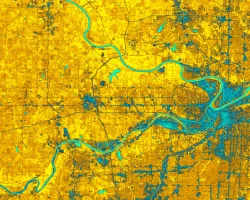
Kansas City Disasters (Summer 2022) Team: M. René Castillo, Hadwynne Gross, Eric Sjöstedt, Raychell Velez Summary: Pluvial flooding, over-saturated ground, and poor drainage systems disproportionately...
![NDVI-processed imagery from Landsat 8 OLI data. This composite image of Wichita, KS, was created using 2018–2022 summer imagery. Lighter shades of yellow indicate limited vegetation in built-up areas and bodies of water, while darker shades of purple indicate dense vegetation. Understanding the spatial distribution of vegetation, such as tree canopy, is essential to recognizing and mitigating heat risk, and prioritizing intervention.](/sites/default/files/styles/lis/public/2022-11/2022Sum_VEJ_WichitaClimate_WebsiteImage.jpg.webp?itok=1WmU74Wp)
Topic
Wichita Climate (Summer 2022) Team: Brooke Laird (Project Lead), Melissa Ashbaugh, Muskaan Khemani, Sadie Murray Summary: Wichita, Kansas is facing a host of climate threats...
![Fall 2022 Maldives Climate](/sites/default/files/styles/lis/public/2023-02/2022Fall_ARC_MaldivesClimate_WebsiteImage.jpg.webp?itok=6Go_gwk1)
Topic
Maldives Climate (Fall 2022) Team: Aidan Harvey (Project Lead), Daniel Lopez, Mitch Porter, Derek Chin Summary: Global sea level rise as a result of climate...
![NDWI-processed imagery from Landsat 8 Operational Land Imager data. This mosaicked image was taken from January to December 2021 of Jekyll Island, Georgia. NDWI contrasts the water features in a satellite image to its surroundings by measuring the moisture content. Low moisture content is shown in white, and high moisture content is shown in blue.](/sites/default/files/styles/lis/public/2023-02/2022Fall_GA_Disasters_WebsiteImage.png.webp?itok=_4Frkxe1)
Georgia Disasters (Fall 2022) Team: Isabella Chittumuri (Project Lead), Nancee Uniyal, Nathan Tesfayi, Shakirah Rogers Summary: In September 2017, Hurricane Irma made landfall in southern...