Topic
Wichita Climate II (Fall 2022) Team: Ritisha Ghosh (Project Lead), Richard Kirschner, Ria Mukherjee, Raina Monaghan Summary: Wichita, Kansas is experiencing a host of climate...
Topic
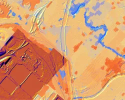
PI: Ashley Ballantyne, University of Montana Co-I: Marie Johnson, University of Montana Fire and other climate driven disturbances are shaping the future of our forests...
Topic
Mary Ellen Miller, Michigan Technological University Michael Billmire, Michigan Technological University Janice Coen, University Corporation For Atmospheric Research (UCAR) Wildfire is a known agent of...
Topic
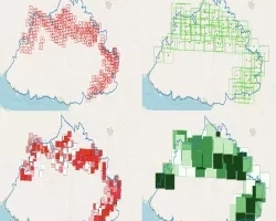
PI: Thomas Buchholz, Spatial Informatics Group Co-I: Max Moritz, Spatial Informatics Group Co-I: Graham Wesolowski, Spatial Informatics Group Natural Assets Laboratory Wildfire probability maps are...
Topic
PI: Pete Robichaud, U.S. Forest Service Co-I: Mariana Dobre. University of Idaho Co-I: Ian Floyd. U.S. Army Engineer Research and Development Center Co-I: Mary Miller...
Topic
PI: Shubharoop Ghosh, ImageCat Co-Is : Tirtha Banerjee, PhD, University of California Irvine and Ronald Eguchi, ImageCat Catastrophic wildfire economic losses in recent years underscore...
Topic
Joel T. Johnson, The Ohio State University Dustin Horton, The Ohio State University The incorporation of soil moisture information into wildfire prediction is becoming increasingly...
Topic
This Phase I study effort will begin the process of increasing exposure of NASA’s Wildland Fire Management Program and data with the Moraga-Orinda Fire District...