Start Date: Feb. 23, 2022
Type: Floods
Region: Oceania
Info & Resources:
- View Products on the NASA Disasters Mapping Portal
- NASA Disasters Program Resources for Floods
- NASA Earthdata Toolkits - Floods
- NASA Earth Observatory - Floods Swamp Eastern Australia
- NASA's Land, Atmosphere Near real-time Capability for EOS (LANCE)
- NASA Worldview
- Australian Bureau of Meteorology (BOM)
Australia declared a national emergency March 9, 2022 due to a series of floods from torrential rain in the eastern region of the country that began in late Feb., impacting South East Queensland, Wide Bay–Burnett and parts of coastal New South Wales. Media reports estimated at least 22 deaths and upwards of $2.5 billion damage related to the floods.
In its role to advance applied research for risk reduction, response and recovery for floods and other disasters, the NASA Earth Science Applied Sciences Disasters program area activated in support of the Australia floods. NASA Disasters coordinators and researchers supported a request from the Australia Bureau of Meteorology to NASA Disasters coordinators and researchers supported a request from the Australia Bureau of Meteorology to the LANCE and Worldview teams via NASA Earthdata for assistance in determining flood extent in New South Wales and information to enhance situational awareness.
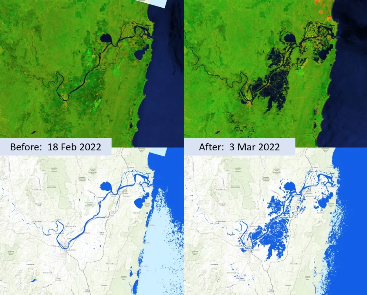
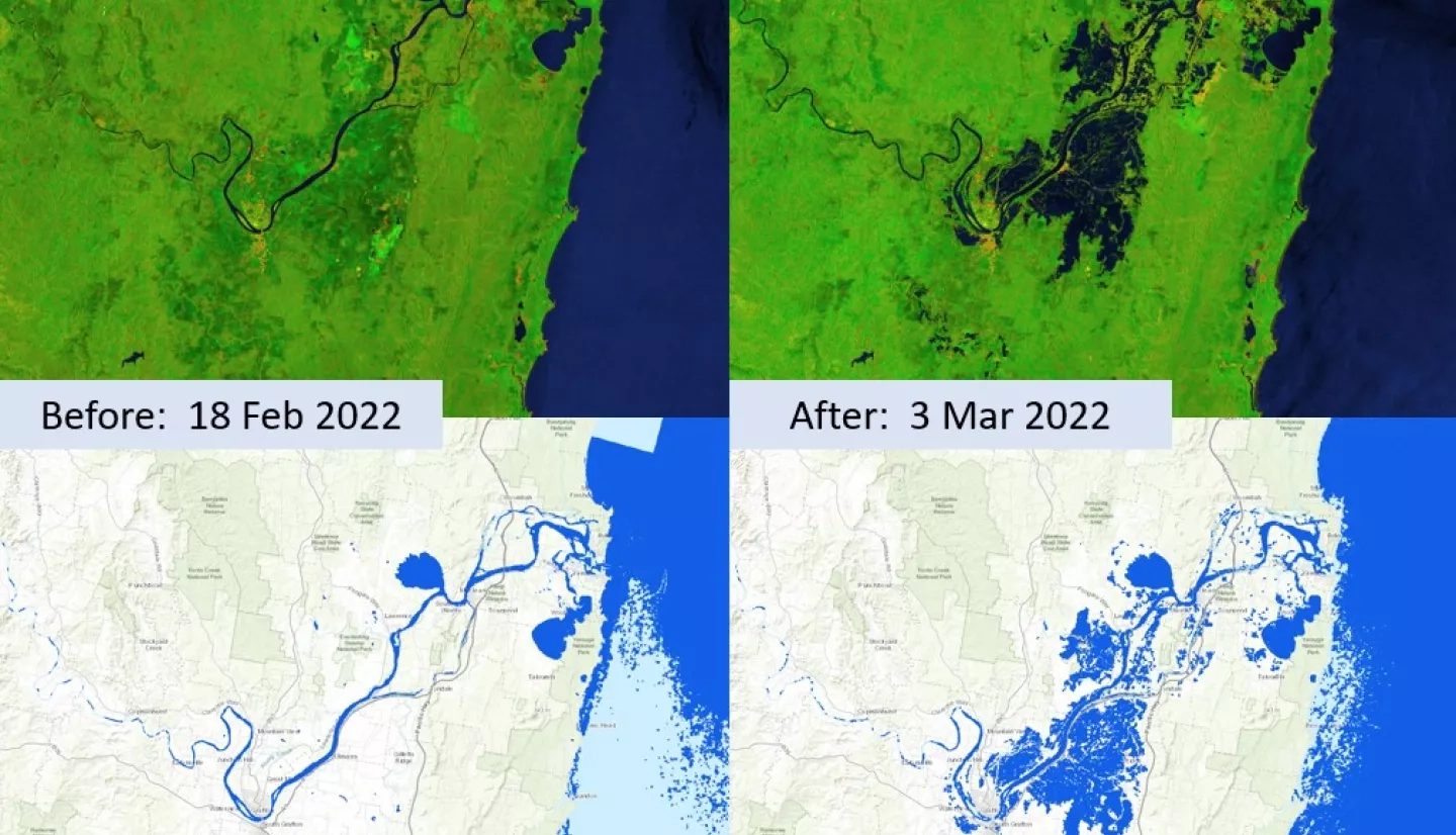
The imagery above, derived from ESA Sentinel-1 satellite observations from Feb. 18, 2022, at 1900 UTC (Local: Feb. 19 0600 AEDT) and March 2, 2022, at 1900 UTC (Local: March 3, 2022, at 0600 AEDT) in eastern Australia, provides two different methods to view before and after floodwater conditions. The top row shows a false-color composite product that offers a qualitative assessment of the region as the SAR satellite views it. In this image, greens indicate vegetated areas, shades of orange and brown tend to be built-up regions such as cities and towns, and blue indicates water. The lower row is a derived open water extent product designed to provide a quantitative product of open water viewable to the satellite. When combined with ancillary datasets such as known water layers, road networks, and building footprints, products such as this can be used to assess water location over a large area and identify potentially flooded regions.
Products for the 2022 Australian floods are available in the NASA Disasters Mapping Portal. The Sentinel-1 imagery on the portal is an output of the ROSES A.37 research project, “Integrating SAR Data for Improved Resilience and Response to Weather-Related Disasters,” led by University of Alaska Fairbanks professor Franz Meyer with researchers at NASA’s Marshall Space Flight Center (MSFC). PlanetScope imagery by Planet Labs Inc. is also provided on the portal as a use case from the Commercial Smallsat Data Acquisition (CSDA) Program.