On Aug. 14, a magnitude 7.2 earthquake struck southwestern Haiti approximately 75 miles west of the capital Port-au-Prince, according to the U.S. Geological Survey (USGS). The earthquake exposed more than 1 million people in the region to very strong to severe shaking, has triggered landslides in mountainous areas, and has resulted in a large number of deaths and extensive damage to buildings and infrastructure, according to preliminary estimates from the news media and Haiti’s civil protection agency. Heavy rainfall from Tropical Storm Grace on Aug. 16 and 17 has compounded the impacts of the disaster, causing flash flooding and additional landslides, and disrupting the earthquake rescue and recovery efforts. The International Disasters Charter has been activated in support of both the earthquake and floods in Haiti.
NASA has unique capabilities to monitor disasters from an integrated Earth systems perspective, and is leveraging these capabilities and expertise to provide support for the cascading disasters in Haiti. To that end, the NASA Earth Applied Sciences Disasters program area has activated to provide Earth-observing maps, data and analysis to support local response and recovery efforts. The Program is working to identify humanitarian, infrastructure, and economic impacts, as well as opportunities to advance scientific knowledge. Simultaneously, the Program is working with numerous stakeholders, including the Haiti Directorate for Civil Protection (DPC), the Committee on Earth Observations (CEOS) Recovery Observatory, the World Food Programme (WFP), the Pacific Disaster Center (PDC), the USAID Bureau of Humanitarian Assistance (BHA), U.S. Southern Command (SOUTHCOM), the U.S. Geological Survey (USGS), the Caribbean Disaster Emergency Management Agency (CDEMA), the Geotechnical Extreme Events Reconnaissance (GEER) Association, and the California Seismic Safety Commission. The team is participating in coordination calls hosted by the BHA and is providing maps and data on the NASA Disasters Mapping Portal, including experimental applied research products and near real-time satellite data.
NASA’s coordination efforts are greatly enhanced by relationships established during prior disaster activations, exercises, and working groups. Examples include the Tradewinds exercises with US SOUTHCOM, contributing to the Caribbean Geoportal, participating in AmeriGEO, and the CEOS Disasters Working Group (WGDisasters), which recently published a report on Earth observations used for recovery from 2016’s Hurricane Matthew in Haiti.
A Damage Proxy Map (DPM) depicting areas likely damaged by the M7.2 earthquake derived from analysis of Copernicus Sentinel-1 radar images acquired on 8/15 and two earlier dates. This interactive map initially focuses on the city of Les Cayes on the south coast. Credits: NASA JPL ARIA, Earth Observatory of Singapore. Contains modified Copernicus 2021 data, processed by ESA and NASA JPL.
View fullscreen
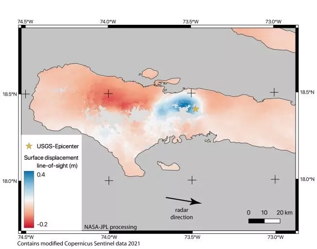
The NASA JPL Advanced Rapid Imaging and Analysis project (ARIA) and the Earth Observatory of Singapore have generated preliminary Damage Proxy Maps (DPM’s) of the region using Copernicus Sentinel-1 synthetic aperture radar (SAR) data acquired on Aug. 15 and two earlier dates. They have provided these maps to multiple stakeholders, including the WFP, USGS, and CDEMA, to assist in tracking damage to buildings and infrastructure from the earthquake.
Shown above is an interactive map showing an Aug. 15 DPM of the city of Les Cayes and surrounding regions. Buildings that are likely damaged are shown in yellow points (less severe damage) and red points (more severe damage). These maps allow local responders to gain a better awareness of the extent of the disaster and its impacts on local communities and can inform them on how to best allocate emergency management resources. In a separate map, the DPM is overlaid with population data from the NASA/Columbia University Socioeconomic Data and Applications Center (SEDAC) to provide additional insights into the impacts on local populations. These ARIA DPM’s are developed with support from the NASA ROSES A.37 research project “Global Rapid Damage Mapping System with Spaceborne SAR Data.” SAR data was also used to generate the surface displacement map shown at the top of the article, providing additional insights into the most affected regions.
While medium-resolution satellite observations from Sentinel-1 SAR can provide preliminary guidance on the areas impacted by a disaster, they must often be verified by other methods to determine their accuracy. Recent in-person observations of the Les Cayes region by local emergency management teams have indicated that the extent of the damage within Les Cayes is actually less than what is indicated by the above DPM’s, while there is elevated damage in the more rural areas to the North of Les Cayes itself. It is also important to note that, due to the limitations of available SAR data and the experimental nature of DPM’s, there are likely significant numbers of false positives in mountainous and vegetated areas and over water. DPM’s are most useful in urban areas as they are sensitive to building damage, but small-scale change or partial structural damage may not be detected. Some strong ground surface changes due to landslides, liquefaction, or flooding can also show as positive areas on the DPM.
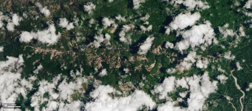
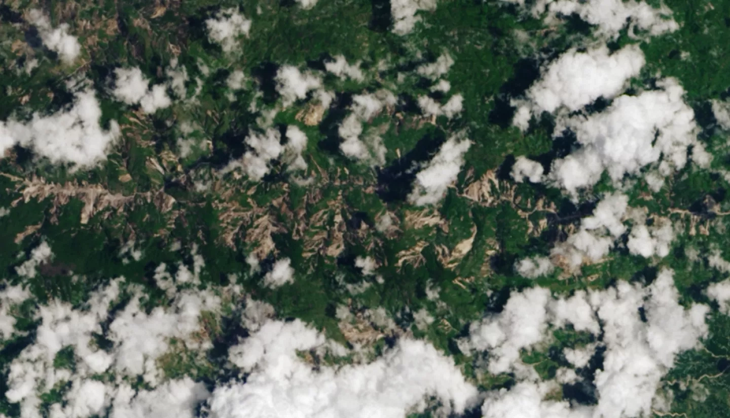
Credits: NASA GSFC Landslides Team. Contains modified Copernicus 2021 data, processed by ESA and NASA.
View fullscreen
The NASA Goddard Space Flight Center landslides team, with support from the A.37 ROSES research project “Enabling Landslide Disaster Risk Reduction and Response Throughout the Disaster Life Cycle With a Multi-scale Toolbox,” has mapped landslides in the region using the Semi-Automatic Landslide Detection (SALaD) system. SALaD uses optical satellite imagery and machine learning to identify areas potentially affected by landslides. In conjunction with the other data available, these provide additional awareness for responders on the ground, and the landslide inventories have been provided to the WFP, USGS, and PAHO. The interactive map above shows potential landslides in red while the ESA Sentinel-2 natural color imagery used to generate the landslide inventory is shown in the background. It is important to note that much of the epicentral area has been consistently covered by clouds, precluding any mapping of landslides in this area. As such, the overall number and extent of landsliding is likely to be larger than the area mapped so far. The Disasters team will continue to provide updates in conjunction with USGS partners.
The ROSES A.37 research project “Integrating SAR Data for Improved Resilience and Response to Weather-Related Disasters” is also providing support for the event, providing interferograms of the region on the SARVIEWS data portal.
NASA continues to monitor the region as the situation unfolds and is working to equip stakeholders with the tools they need to make informed decisions for response and recovery.