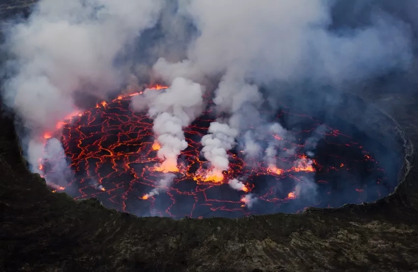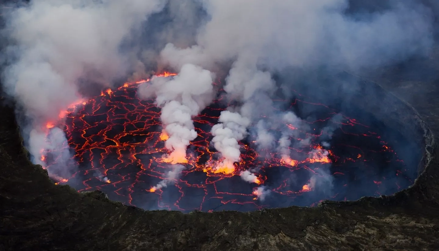
The Mt. Nyiragongo volcano in the Democratic Republic of Congo began erupting the morning of Saturday, May 22, 2021, with fissures in the southern side of the volcano sending lava pouring into nearby towns. The eruption resulted in the deaths of at least 31 people as of May 26 according to media reports, and official reports from the Ministry of Communications of the Democratic Republic of Congo indicate that 232,433 people were evacuated from the region. This is the first major eruption of Mt. Nyiragongo since 2002, which resulted in the deaths of 245 people and left over 120,000 homeless.
Mt. Nyiragongo is unique in being one of the few volcanoes in the world that hosts a near-persistent lava lake, with large volumes of molten lava contained within its volcanic crater. Mt. Nyiragongo is in a chain of volcanoes that is part of the GEO GSNL Virunga supersite, an international partnership that promotes open access to geophysical satellite data and analysis to support disaster risk reduction.
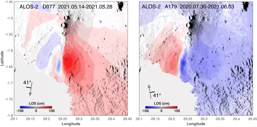
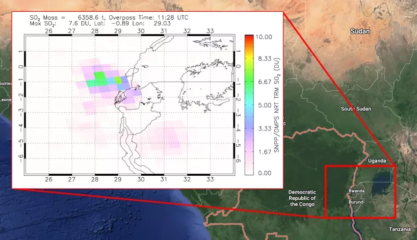
NASA’s Earth Applied Sciences Disasters program area has activated efforts to monitor the eruption with Earth-observing data and assist risk reduction, response and recovery efforts. The program is responding to a request for assistance from Geoscience Australia on behalf of Rwanda, to aid in interferometric analysis of ESA Sentinel-1 satellite data, and monitoring methane emissions that have been reported at Lake Kivu.
Regional stakeholders are also monitoring for any signs that may indicate a potential limnic eruption in Lake Kivu. Also known as “lake overturn,” a limnic eruption is a rare type of disaster in which dissolved gasses such as carbon dioxide or methane rapidly erupt from deep lake waters, forming a gas cloud capable of suffocating wildlife, livestock, and humans. Limnic eruptions can be caused by differences in temperature and gas concentration in the upper and lower layers of a lake, and it has been speculated that ground movement or temperature changes caused by volcanic activity may trigger such an event. However, the phenomenon is poorly understood and difficult to monitor via satellite remote sensing.
The program is also in contact with stakeholders and subject matter experts from the Goma Volcano Observatory, the USGS Volcano Disaster Assistance Program (VDAP), the Rwanda Space Agency, the British Geologic Survey, the Italian National Institute of Geophysics and Volcanology (INGV), as well as partners at the U.S. Department of State and the U.S. Agency for International Development (USAID). The program is also coordinating with members of NASA’s Health and Air Quality Applied Sciences Team (HAQAST).
Several NASA ROSES A.37 research projects are providing support for the eruption, including “Day-Night Monitoring of Volcanic SO2 and Ash for Aviation Avoidance,” “Integrating SAR Data for Improved Resilience and Response to Weather-Related Disasters,” and “Global Rapid Damage Mapping System with Spaceborne SAR Data,”