Displaying 151 - 160 of 305
![](/sites/default/files/styles/lis/public/images/develop-legacy/2019/summer/images/2019Sum_MSFC_CentralAmericaTI_WebsiteImage.jpg.webp?itok=DWQOzdqL)
Topic
Central America is one of the world’s most vulnerable regions to natural disasters, including landslides and precipitation-driven flooding. In an effort to support disaster management...
![NDWI-processed composite image from Landsat 8 OLI data of the Lower Illinois River Valley and surrounding landscapes from summer 2021. Shades of pale yellow indicate dry vegetation and dark teal represents open water, while brighter turquois values depict wet vegetation. Areas of high NDWI values are demonstrative of high presence of wet vegetation and are of interest to the Great Rivers Land Trust in identifying areas of interest for wetland conservation.](/sites/default/files/styles/lis/public/2022-12/2022Sum_JPL_LowerIllinoisEco_WebsiteImage.png.webp?itok=eCvz2h8C)
Lower Illinois River Valley Ecological Forecasting (Summer 2022) Team: Vanessa Machuca (Project Lead), Dana Myers, Hannah Rigdon, Christiana Saldana Summary: The Lower Illinois River Valley...
![The image was collected by Landsat 9 on January 26 of 2023 showing Skidaway Island and waterways on the Georgia coast. The data shows areas of healthy vegetation and urban areas using a Normalized Difference Vegetation Index (NDVI). The darker orange represents grass and urban areas. Yellow and purple represents forested and densely vegetated areas. The black represents open water.](/sites/default/files/styles/lis/public/2023-05/2023Spring_GA_GeorgiaDisastersII_WebsiteImage.jpg.webp?itok=zhMhpiSz)
Georgia Disasters II (2023 Spring) Team: Shakirah Rogers (Project Lead), Nathan Tesfayi, Matthew Murray, Clarence Jackson Summary: Heirs property owners are especially vulnerable to natural...
![](/sites/default/files/styles/lis/public/images/develop-legacy/2020/fall/images/2020Fall_MA_CharlesRiverWatershedWater_WebsiteImage.jpg.webp?itok=DHzT_yqT)
Topic
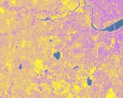
The Charles River watershed intersects 35 municipalities within the Boston Metropolitan Area and has a population of 1.2 million, making it one of the most...
![Normalized Difference Water Index (NDWI) to visualize drainage networks around the Unalakleet River in Alaska, calculated from an August 2021 Landsat 8 OLI image. Yellow represents standing or flowing water and potential flood zones, while the dark blue represents drier, upland regions. Unalakleet's climate resilience planning prioritizes relocation to upland regions while avoiding areas that have experienced significant permafrost degradation.](/sites/default/files/styles/lis/public/2023-10/2023Sum_GA_UnalakleetClimate_WebsiteImage.jpg.webp?itok=9m9RUwoB)
Unalakleet Climate (Summer 2023) Team: Ian Lee (Project Lead), Clara Maxwell, Daniel J. Marsden, M. Jaweed Nazary Summary: The coastal community of Unalakleet is currently...
Topic
When an earthquake occurs, seismic data provides an initial estimate of magnitude and location. However, for large earthquakes, we can improve our situational awareness once...
![This map produced from JAXA ALOS-2 satellite data shows surface displacement caused by the 7.4 magnitude earthquake in Mexico. Credit: NASA, JAXA Sang-Wan Kim, Batu Osmanoglu, and Min-Jeong Jo](/sites/default/files/styles/lis/public/2020-06/ALOS-2-deformation-map-mexico-earthquake-2020.jpg.webp?itok=3Pmvha3y)
![](/sites/default/files/styles/lis/public/images/develop-legacy/2020/fall/images/2020Fall_MSFC_Amazonia_Disasters_Website_Image.jpg.webp?itok=8SzNXrl9)
Topic
Artisanal and small-scale gold mining (ASGM) is responsible for a large fraction of deforestation and disturbance in Amazonia. These activities cause severe impacts on the...
![](/sites/default/files/styles/lis/public/images/develop-legacy/2021/summer/images/2021Sum_JPL_CoastalCaliforniaWaterII_WebsiteImage.jpg.webp?itok=vq31qia9)
Topic
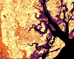
Estuaries are dynamic environments that provide a host of vital ecosystem services. California’s Marine Life Protection Act protects such ecosystems by creating Marine Protected Areas...
Topic
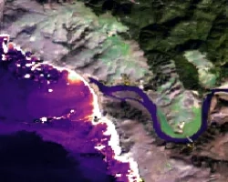
Nearly a quarter of California's fresh water supply flows through the Sacramento-San Joaquin Delta, an area comprised of tidal marshland and reclaimed land in the...